
-
Federal
OMPS-NPP L2 LP Ozone (O3) Vertical Profile swath daily Center slit V2.6 (OMPS_NPP_LP_L2_O3_DAILY) at GES DISC
National Aeronautics and Space Administration —
Version 2.6 is the current version of this data product, and supersedes all previous versions.The OMPS-NPP L2 LP Ozone (O3) Vertical Profile swath daily Center slit... -
Federal
OMPS-NPP L2 NP Ozone (O3) Vertical Profile swath orbital
National Aeronautics and Space Administration —
The OMPS-NPP L2 NP Ozone (O3) Total Column swath orbital product provides ozone profile retrievals from the Ozone Mapping and Profiling Suite (OMPS) Nadir-Profiler... -
Federal
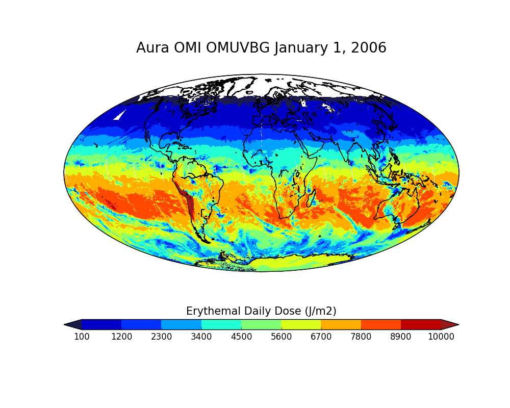
OMI/Aura Surface UVB Irradiance and Erythemal Dose Daily L2 Global Gridded 0.25 degree x 0.25 degree V3 (OMUVBG) at GES DISC
National Aeronautics and Space Administration —
This is Level-2G daily global gridded Aura-OMI Spectral Surface UVB Irradiance and Erythemal Dose product (OMUVBG). The OMUVBG is a special Level-2 Global Gridded... -
Federal
OMI/Aura Ozone (O3) Total Column Daily L2 Global Gridded 0.25 degree x 0.25 degree V3 (OMTO3G) at GES DISC
National Aeronautics and Space Administration —
This Level-2G daily global gridded product OMTO3G is based on the pixel level OMI Level-2 Total Ozone Product OMTO3. The OMTO3 product is from the enhanced TOMS... -
Federal
OCO-2 Gridded bias-corrected XCO2 and other select fields aggregated as Level 3 daily files V4 (OCO2GriddedXCO2)
National Aeronautics and Space Administration —
Gridded carbon dioxide mole fraction (XCO2) and other select variables created by applying local kriging (also known as optimal interpolation) to daily aggregates of... -
Federal
ATMOS L2 Trace Gases on Altitude Grid, Fixed Field Format V3 (ATMOSL2AF) at GES DISC
National Aeronautics and Space Administration —
This is the version 3 Atmospheric Trace Molecule Spectroscopy (ATMOS) Level 2 product containing trace gases on a vertical altitude (km) grid with data stored in an... -
Federal
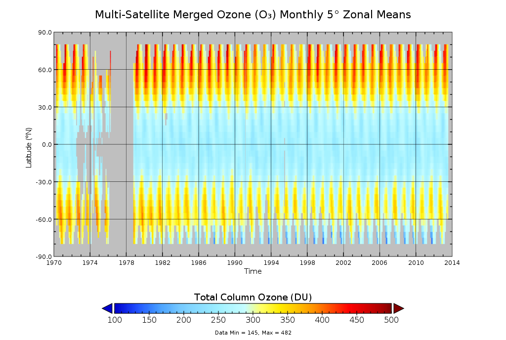
Multi-Satellite Merged Ozone (O3) Profile and Total Column 1 Month Zonal Mean L3 Global 5.0 degree Latitude Zones V1 (MSO3L3zm5) at GES DISC
National Aeronautics and Space Administration —
The merged-satellite Solar Backscattered Ultraviolet (SBUV) Level-3 monthly zonal mean (MZM) product (MSO3L3zm5) contains 1 month zonal means for profile layer and... -
Federal
ATMOS L2 Trace Gases on Altitude Grid, Tab Delimited Format V3 (ATMOSL2AT) at GES DISC
National Aeronautics and Space Administration —
This is the version 3 Atmospheric Trace Molecule Spectroscopy (ATMOS) Level 2 product containing trace gases on a vertical altitude (km) grid with data stored in an... -
Federal
ATMOS L2 Trace Gases on Pressure Grid, Fixed Field Format V3 (ATMOSL2PF) at GES DISC
National Aeronautics and Space Administration —
This is the version 3 Atmospheric Trace Molecule Spectroscopy (ATMOS) Level 2 product containing trace gases on a vertical pressure (atm) grid with data stored in an... -
Federal
MLS/Aura (pre-average radiances) Level 3 Bromine Monoxide (BrO) Daily 10deg Lat Zonal Mean V005 (ML3DZMBRO) at GES DISC
National Aeronautics and Space Administration —
ML3DZMBRO is the EOS Aura Microwave Limb Sounder (MLS) daily zonal mean product for bromine monoxide derived from radiances measured by the 640 GHz radiometer. The... -
Federal
Sounder SIPS: Suomi NPP CrIMSS Level 2 SiFSAP Standard: Atmosphere cloud and surface geophysical state per footprint V2 (at GESDISC)
National Aeronautics and Space Administration —
This level 2 standard product is generated by the SiFSAP (Single Field-of-View Sounder Atmospheric Products) algorithm. The SIFSAP algorithm provides retrieval for... -
Federal
Sounder SIPS: Suomi-NPP ATMS Level 1 Daily Polygon Granule Map at GES DISC
National Aeronautics and Space Administration —
The Advanced Technology Microwave Sounder (ATMS) Level 1B data files contain brightness temperature measurements along with ancillary spacecraft, instrument, and... -
Federal
TOMS Earth-Probe Total Ozone (O3) Aerosol Index UV-Reflectivity UV-B Erythemal Irradiances Daily L3 Global 1 deg x 1.25 deg V008 (TOMSEPL3) at GES DISC
National Aeronautics and Space Administration —
The Earth Probe (EP) Total Ozone Mapping Spectrometer (TOMS) version 8 daily global gridded data product contains total column ozone, UV aerosol index, Lambertian... -
Federal
Sounder SIPS: AQUA AIRS IR + MW Level 3 CLIMCAPS : Comprehensive Quality Control Gridded Daily V2 (SNDRAQIML3CDCCP) at GES DISC
National Aeronautics and Space Administration —
WARNING: To users of the derived product “co_mmr_midtrop” (carbon monoxide mass mixing ratio to dry air [kg/kg] at ~500 hPa). This variable has a significant bias due... -
Federal
OCO-3 Level 2 spatially ordered geolocated retrievals screened using the IMAP-DOAS Preprocessor (IDP), Retrospective Processing V11r (OCO3_L2_IMAPDOAS) at GES DISC
National Aeronautics and Space Administration —
Version 11r is the current version of the data set. Older versions will no longer be available and are superseded by Version 11r.The Orbiting Carbon Observatory -3... -
Federal
OCO-3 Level 2 spatially ordered geolocated retrievals screened using the IMAP-DOAS Preprocessor (IDP), Retrospective Processing V10r (OCO3_L2_IMAPDOAS) at GES DISC
National Aeronautics and Space Administration —
Version 10r is the current version of the data set. Older versions will no longer be available and are superseded by Version 10r.The Orbiting Carbon Observatory -3... -
Federal
OCO-2 Level 2 bias-corrected solar-induced fluorescence and other select fields from the IMAP-DOAS algorithm aggregated as daily files, Retrospective processing V10r (OCO2_L2_Lite_SIF) at GES DISC
National Aeronautics and Space Administration —
Version 10r is the current version of the data set. Older versions will no longer be available and are superseded by Version 10r. The OCO-2 SIF Lite files contain... -
Federal
OCO-2 Level 2 geolocated XCO2 retrieval results and algorithm diagnostic information Retrospective Processing V11.2r (OCO2_L2_Diagnostic) at GES DISC
National Aeronautics and Space Administration —
Version 11.2r is the current version of the data set. Older versions will no longer be available and are superseded by Version 11.2r.The Orbiting Carbon Observatory... -
Federal
OCO-2 Level 2 meteorological parameters interpolated from global assimilation model for each sounding, Retrospective Processing V11r (OCO2_L2_Met) at GES DISC
National Aeronautics and Space Administration —
Version 11r is the current version of the data set. Older versions will no longer be available and are superseded by Version 11r.The Orbiting Carbon Observatory is... -
Federal
OCO-2 Level 2 spatially ordered geolocated retrievals screened using the A-band Preprocessor, Retrospective Processing V11r (OCO2_L2_ABand) at GES DISC
National Aeronautics and Space Administration —
Version 11r is the current version of the data set. Older versions will no longer be available and are superseded by Version 11r.The Orbiting Carbon Observatory is...

Official websites use .gov
A
.gov website belongs to an official government
organization in the United States.
Secure .gov websites use HTTPS
A
lock (
) or https:// means you’ve safely connected to
the .gov website. Share sensitive information only on official,
secure websites.