

7,180 datasets found for "84p직장인디비문의l(텔레darknessDB§"
-
Federal
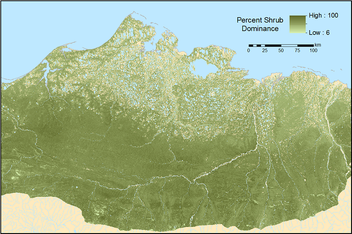
ABoVE: Gridded 30-m Aboveground Biomass, Shrub Dominance, North Slope, AK, 2007-2016
National Aeronautics and Space Administration —
This dataset includes 30-m gridded estimates of total plant aboveground biomass (AGB), the shrub AGB, and the shrub dominance (shrub/plant AGB) for non-water portions... -
Federal
ABoVE: CO2 and CH4 Fluxes and Meteorology at Flux Tower Sites, Alaska, 2015-2017
National Aeronautics and Space Administration —
This dataset provides CO2 and CH4 fluxes and meteorological parameters from five eddy covariance (EC) tower sites located at Barrow (three sites), Atqasuk (ATQ) and... -
Occupancy Permits in 2018
District of Columbia —
The dataset contains locations and attributes for above ground permits applied for and approved by the District Department of Transportation. They are existing... -
Occupancy Permits in 2019
District of Columbia —
The dataset contains locations and attributes for above ground permits applied for and approved by the District Department of Transportation. They are existing... -
Parking Violations Issued in June 2017
District of Columbia —
Parking citation locations in the District of Columbia. The data contained in this layer pertain to parking violations issued by the District of Columbia's... -
State
i06 Bathy NOAA 1992 SacramentoRiverNearRioVista and CentralDelta
State of California —
This service, (i06_SingleBeam_Bathymetry) is a service containing point feature layers with single beam bathymetric data collected by California Department of Water... -
State
i06 Bathy NCRO 20080708 GeorgianaSlough
State of California —
This service, (i06_SingleBeam_Bathymetry) is a service containing point feature layers with single beam bathymetric data collected by California Department of Water... -
State
i06 Bathy CVFED DWR 2010 SanJoaquinRiver and Tributaries
State of California —
This service, (i06_SingleBeam_Bathymetry) is a service containing point feature layers with single beam bathymetric data collected by California Department of Water... -
State
i06 Bathy NCRO 20170807 FeatherRiver
State of California —
This service, (i06_SingleBeam_Bathymetry) is a service containing point feature layers with single beam bathymetric data collected by California Department of Water... -
State
i06 Bathy NCRO 20080710 SutterSlough
State of California —
This service, (i06_SingleBeam_Bathymetry) is a service containing point feature layers with single beam bathymetric data collected by California Department of Water... -
State
SUD Recovery Treatment Facilities
State of California —
This is an alphabetical list by county of all non-medical alcoholism and drug abuse recovery or treatment facilities licensed and/or certified by the Department of... -
State
Chart 3.8 MCP Utilization Rates for Community Supports in the Last 12 Months of the Reporting Period
State of California —
ECM Community Support Services tables for a Quarterly Implementation Report. Including the County and Plan Details for both ECM and Community Support.This Medi-Cal... -
State
Chart 4.3.1 Total Number of Community Supports Provider Contracts by Service in Each Quarter
State of California —
ECM Community Support Services tables for a Quarterly Implementation Report. Including the County and Plan Details for both ECM and Community Support.This Medi-Cal... -
State
SB 535 Disadvantaged Communities 2022 (Federal Tribal Areas)
State of California —
This map shows the 2022 disadvantaged communities designated by CalEPA for the purpose of SB 535. These areas represent:Highest scoring 25% of census tracts from... -
State
DWR Telemetered Wells
State of California —
The Department of Water Resources Telemetered Wells dataset contains information regarding wells within the DWR monitoring network that have telemetry equipment... -
State
Chart 4.5.2 Total Number of Community Supports Provider Contracts in Each MCP and County in the Most Recent Reporting Quarter by Service
State of California —
ECM Community Support Services tables for a Quarterly Implementation Report. Including the County and Plan Details for both ECM and Community Support.This Medi-Cal... -
State
Herp Searches - Spears and Didion Ranches [ds323]
State of California —
These data are detections of reptiles in 2005 from visual encounter searches of an area constrained to a 100-m radius circle around each of 15 fixed sample points at... -
Federal
SAFARI 2000 Modeled Tropospheric Air Mass Trajectories, Dry Season 2000
National Aeronautics and Space Administration —
The ETA Forecast Trajectory Model was used to produce forecasts of air-parcel trajectories twice a day at three pressure levels over seven sites in Southern Africa... -
Federal
Remote Sensing Systems Radiometer Rain Collocations with JPL RapidScat L2B Swath Grid
National Aeronautics and Space Administration —
This dataset contains the multi-sourced microwave radiometer wind speed, rain and cloud liquid water data collocated to RapidScat Level 2B wind vector cell (WVC)...
7,180 datasets found for "84p직장인디비문의l(텔레darknessDB§"