

7,178 datasets found for "84p직장인디비문의l(텔레darknessDB§"
-
State
San Simeon Slender Salamander Range - CWHR A059 [ds1175]
State of California —
Vector datasets of CWHR range maps are one component of California Wildlife Habitat Relationships (CWHR), a comprehensive information system and predictive model for... -
State
Newly Eligible Individuals by Insurance Affordability Program (IAP)
State of California —
This dataset includes the total number of newly eligible individuals by Insurance Affordability Program (IAP), by reporting period. IAPs include Medi-Cal, Covered... -
State
Tehachapi Slender Salamander Range - CWHR A018 [ds1147]
State of California —
Vector datasets of CWHR range maps are one component of California Wildlife Habitat Relationships (CWHR), a comprehensive information system and predictive model for... -
State
Black Salamander Range - CWHR A020 [ds1149]
State of California —
Vector datasets of CWHR range maps are one component of California Wildlife Habitat Relationships (CWHR), a comprehensive information system and predictive model for... -
State
Aquatic Rare Amphibian Richness - ACE [ds2750]
State of California —
For more information, see the Aquatic Rare Species Richness Factsheet at https://nrm.dfg.ca.gov/FileHandler.ashx?DocumentID=150853. The California Department of Fish... -
State
Vegetation - Suisun Marsh - 2012 [ds1029]
State of California —
Vegetation delineations based on photo interpretation and formal vegetation classification plus change detection. -
State
Cordilleran Flycatcher Range - CWHR B550 [ds1686]
State of California —
Vector datasets of CWHR range maps are one component of California Wildlife Habitat Relationships (CWHR), a comprehensive information system and predictive model for... -
State
i07 Water Shortage Vulnerability Sections
State of California —
This dataset represents a water shortage vulnerability analysis performed by DWR using modified PLSS sections pulled from the Well Completion Report PLSS Section... -
State
Vegetation - Suisun Marsh - Change 1999 to 2003 [ds164]
State of California —
This vegetation mapping project of Suisun Marsh blends ground-based classification, aerial photo interpretation, and GIS editing and processing. The method is based... -
State
Yellow-Rumped Warbler Range - CWHR B435 [ds1630]
State of California —
Vector datasets of CWHR range maps are one component of California Wildlife Habitat Relationships (CWHR), a comprehensive information system and predictive model for... -
State
Interstate Connections - California Essential Habitat Connectivity (CEHC) [ds619]
State of California —
The California Department of Transportation (Caltrans) and California Department of Fish and Game (CDFG) commissioned the California Essential Habitat Connectivity... -
Federal
Western North American FLEXPART Back Trajectory 2003 Data
National Aeronautics and Space Administration —
WNA-FLEXPART-BackTraj-2003 is the 2003 Western North America Back Trajectory data using the FLEXible PARTicle (FLEXPART) dispersion model. Data collection for this... -
Federal
Soil Organic Carbon Stock Estimates with Uncertainty across Latin America
National Aeronautics and Space Administration —
This dataset provides 5 x 5 km gridded estimates of soil organic carbon (SOC) across Latin America that were derived from existing point soil characterization data... -
Federal
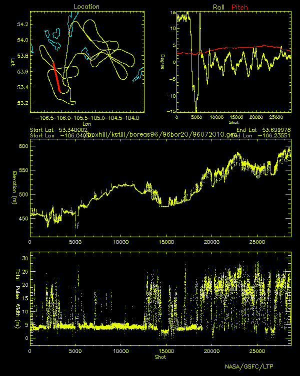
BOREAS Scanning Lidar Imager of Canopies by Echo Recovery (SLICER): Level-3 Data
National Aeronautics and Space Administration —
Scanning Lidar Imager of Canopies by Echo Recovery (SLICER) data were acquired in support of BOReal Ecosystem-Atmosphere Study (BOREAS) at all of the Tower Flux (TF)... -
Federal
ATom: CAM-chem/CESM2 Model Outputs Along Flight Tracks, 2016-2018
National Aeronautics and Space Administration —
This dataset contains CAM-chem (Community Atmosphere Model with Chemistry) model outputs along ATom flight tracks. CAM-chem is a component of the Community Earth... -
Federal
A Compilation of Global Soil Microbial Biomass Carbon, Nitrogen, and Phosphorus Data
National Aeronautics and Space Administration —
This data set provides the concentrations of soil microbial biomass carbon (C), nitrogen (N) and phosphorus (P), soil organic carbon, total nitrogen, and total... -
Federal
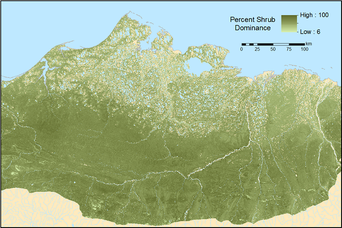
ABoVE: Gridded 30-m Aboveground Biomass, Shrub Dominance, North Slope, AK, 2007-2016
National Aeronautics and Space Administration —
This dataset includes 30-m gridded estimates of total plant aboveground biomass (AGB), the shrub AGB, and the shrub dominance (shrub/plant AGB) for non-water portions... -
Federal
ABoVE: CO2 and CH4 Fluxes and Meteorology at Flux Tower Sites, Alaska, 2015-2017
National Aeronautics and Space Administration —
This dataset provides CO2 and CH4 fluxes and meteorological parameters from five eddy covariance (EC) tower sites located at Barrow (three sites), Atqasuk (ATQ) and...
7,178 datasets found for "84p직장인디비문의l(텔레darknessDB§"