
-
Federal
VIIRS/NPP BRDF/Albedo Parameter 2 Band M7 Daily L3 Global 30 ArcSec CMG V001
National Aeronautics and Space Administration —
The VNP43D17 Version 1 data product was decommissioned on July 31, 2025. Users are encouraged to use theFederalVIIRS/NPP Land Surface Temperature/Emissivity Monthly L3 Global 0.05Deg CMG V002
National Aeronautics and Space Administration —
The NASA/NOAA Suomi National Polar-orbiting Partnership (Suomi NPP) Visible Infrared Imaging Radiometer Suite (VIIRS) Land Surface Temperature and Emissivity...FederalVIIRS/NPP Land Surface Temperature/Emissivity Daily L3 Global 0.05Deg CMG V002
National Aeronautics and Space Administration —
The NASA/NOAA Suomi National Polar-orbiting Partnership (Suomi NPP) Visible Infrared Imaging Radiometer Suite (VIIRS) Land Surface Temperature and Emissivity...FederalVIIRS/NOAA20 Cloud Mask and Spectral Test Results 6-Min L2 Swath 750m
National Aeronautics and Space Administration —
The VIIRS/NOAA20 Cloud Mask and Spectral Test Results 6-Min L2 Swath 750m product Mask is one of three continuity products designed to sustain the long-term records...FederalVIIRS/JPSS1 Moderate Resolution Terrain Corrected Geolocation L1 6-Min Swath 750m
National Aeronautics and Space Administration —
The VIIRS/JPSS1 Moderate Resolution Terrain Corrected Geolocation 6-Min L1 Swath 750m product, short-name VJ103MOD contains the derived line-of-sight (LOS) vectors...FederalVIIRS/NPP Moderate Resolution Bands L1B 6-Min Swath 750 m NRT
National Aeronautics and Space Administration —
The VIIRS/NPP Moderate Resolution Bands L1B 6-Min Swath 750m Near Real Time (NRT) product, short-name VNP02MOD_NRT is among the VIIRS Level 1 and Level 2 swath...FederalVIIRS/JPSS1 FILDA-2 Fire Modified Combustion Efficiency Product 6-min L2 Swath 750m V002
National Aeronautics and Space Administration —
The Visible Infrared Imaging Radiometer Suite (VIIRS) FIre Light Detection Algorithm-2 (FILDA-2) Modified Combustion Efficiency (MCE) Version 2 swath product...FederalVIIRS/JPSS1 FILDA-2 Fire Modified Combustion Efficiency Product 6-min L2 Swath 375 V002
National Aeronautics and Space Administration —
The Visible Infrared Imaging Radiometer Suite (VIIRS) FIre Light Detection Algorithm-2 (FILDA-2) Modified Combustion Efficiency (MCE) Version 2 swath product...FederalVIIRS/JPSS1 Gap-Filled Lunar BRDF-Adjusted Nighttime Lights Daily L3 Global 500m Linear Lat Lon Grid
National Aeronautics and Space Administration —
The NOAA-20 VIIRS Gap-Filled Lunar BRDF-Adjusted Nighttime Lights Daily L3 Global 500m Linear Lat Lon Grid product, short-name VJ146A2 is a daily moonlight- and...FederalVEMAP 1: Georeferencing
National Aeronautics and Space Administration —
The Vegetation/Ecosystem Modeling and Analysis Project (VEMAP) is an ongoing multiinstitutional, international effort addressing the response of biogeography and...FederalTROPICS01 Pathfinder L2B Instantaneous Surface Rain Rate (ISRR) V1.0
National Aeronautics and Space Administration —
The "Time-Resolved Observations of Precipitation structure and storm Intensity with a Constellation of Smallsats" (TROPICS) mission has a goal of providing nearly...FederalSAFARI 2000 Leaf Area Index and Canopy Structure, Kalahari Transect, 1999-2000
National Aeronautics and Space Administration —
Data from the Tracing Radiation and Architecture of Canopies (TRAC) instrument were collected at five sites along the International Geosphere-Biosphere Programme...FederalPARABOLA Data (FIFE)
National Aeronautics and Space Administration —
The Surface Reflectances Measured by the PARABOLA Data Set contains measurements from the Portable Apparatus or Rapid Acquisitions of Bi-directional Observations of...FederalSASS (Subsonics Assessment) Ozone and NOx Experiment (SONEX) Merge Data Files
National Aeronautics and Space Administration —
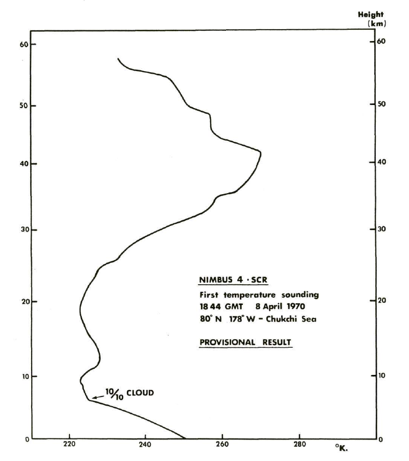
SONEX_Merge_DC8_Data_1 is all of the project generated merge files for the SONEX suborbital campaign. Types of merges include 1- and 5-minute, aerosol composition-...FederalSCR/Nimbus-4 Level 1 Radiance Data from CD-ROM V001 (SCRN4L1RAD_CDROM) at GES DISC
National Aeronautics and Space Administration —
SCRN4L1RAD_CDROM is the gridded Nimbus-4 Selective Chopper Radiometer (SCR) Level 1 Radiance Data Product. The radiances are measured by 16 channels at 2.3 to 15...FederalSBUV2/NOAA-9 Ozone (O3) Nadir Profile and Total Column 1 Day L2 V1 (SBUV2N09L2) at GES DISC
National Aeronautics and Space Administration —
The Solar Backscattered Ultraviolet (SBUV) from NOAA-9 Level-2 daily product (SBUV2N09L2) contains ozone nadir profile and total column data from retrievals generated...FederalRapidScat Level 2B Climate Ocean Wind Vectors in 12.5km Footprints Version 2.0
National Aeronautics and Space Administration —
This dataset contains the RapidScat Level 2B 12.5km Version 2.0 Climate quality ocean surface wind vectors. The Level 2B wind vectors are binned on a 12.5 km Wind...FederalPre-ABoVE: Particle Trajectories for WRF-STILT Model, Barrow, AK, 1982-2011
National Aeronautics and Space Administration —
This dataset provides Stochastic Time-Inverted Lagrangian Transport model outputs for receptors located at the NOAA Barrow Alaska Observatory for 12 selected years...FederalPEM Tropics B DC-8 Remotely Sensed Differential Absorption Lidar (DIAL) Data
National Aeronautics and Space Administration —
PEM-Tropics-B_AircraftRemoteSensing_DC8_DIAL_Data is the remotely sensed Differential Absorption Lidar (DIAL) data collected onboard the DC-8 aircraft during the...FederalOMPS-NPP L2 NM Formaldehyde (HCHO) Total Column swath orbital
National Aeronautics and Space Administration —
The OMPS-NPP L2 NM Formaldehyde (HCHO) Total Column swath orbital product provides formaldehyde measurements from the Ozone Mapping and Profiling Suite (OMPS) Nadir-...9,607 datasets found

Official websites use .gov
A
.gov website belongs to an official government
organization in the United States.
Secure .gov websites use HTTPS
A
lock (
) or https:// means you’ve safely connected to
the .gov website. Share sensitive information only on official,
secure websites.