

593 datasets found
-
Federal
HURRICANE AND SEVERE STORM SENTINEL (HS3) HIGH-ALTITUDE IMAGING WIND AND RAIN AIRBORNE PROFILER (HIWRAP) V1 recent views
National Aeronautics and Space Administration —
The Hurricane and Severe Storm Sentinel (HS3) High-Altitude Imaging Wind and Rain dataset was collected from the High-altitude Imaging Wind and Rain Airborne Profiler... -
Federal
GOES-R PLT Kennedy Space Center Lightning Mapping Array (LMA) V1 recent views
National Aeronautics and Space Administration —
The GOES-R PLT Kennedy Space Center Lightning Mapping Array (LMA) dataset consists of total lightning data measured from the Kennedy Space Center LMA (KSCLMA) network... -
Federal
GPM GROUND VALIDATION VAISALA CEILOMETER IPHEx V1 recent views
National Aeronautics and Space Administration —
The GPM Ground Validation Vaisala Ceilometer IPHEx dataset consists of vertical profiles of attenuated backscatter and cloud base and boundary layer height data... -
Federal
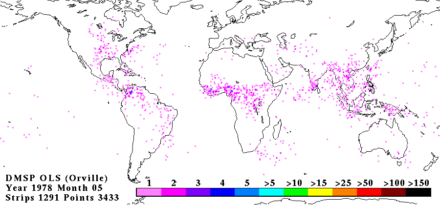
OLS ANALOG DERIVED LIGHTNING V1 recent views
National Aeronautics and Space Administration —
The OLS Analog Derived Lightning dataset consists of global lightning signatures from the Defense Meteorological Satellite Program (DMSP) Operational Linescan System... -
Federal
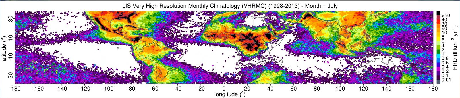
LIS 0.1 DEGREE VERY HIGH RESOLUTION GRIDDED LIGHTNING MONTHLY CLIMATOLOGY (VHRMC) V1 recent views
National Aeronautics and Space Administration —
The LIS 0.1 Degree Very High Resolution Gridded Lightning Monthly Climatology (VHRMC) dataset consists of gridded monthly climatologies of total lightning flash rates... -
Federal
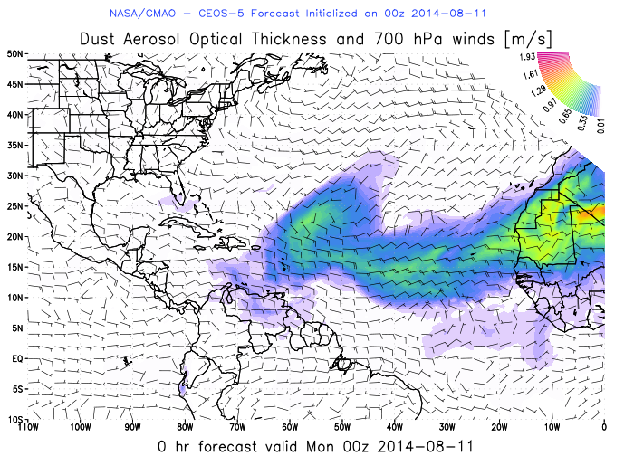
Hurricane and Severe Storm Sentinel (HS3) Global Modeling and Assimilation Office (GMAO) Dust Aerosol Optical Thickness Imagery V1 recent views
National Aeronautics and Space Administration —
The Hurricane and Severe Storm Sentinel (HS3) Global Modeling and Assimilation Office (GMAO) Dust Aerosol Optical Thickness Imagery dataset consists of browse only... -
Federal
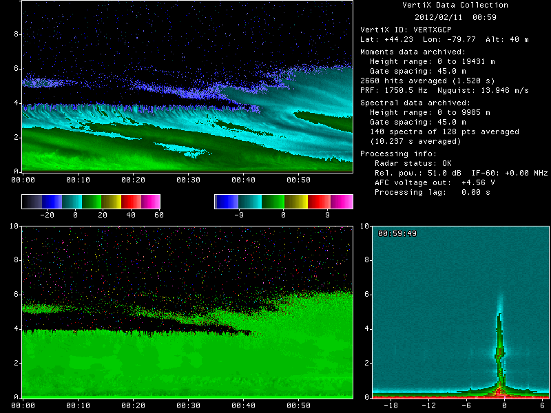
GPM GROUND VALIDATION MCGILL VERTICAL POINTING X-BAND (VERTIX) RADAR GCPEX V1 recent views
National Aeronautics and Space Administration —
The GPM Ground Validation McGill Vertical Pointing X-Band (VertiX) Radar GCPEx dataset consists of radar reflectivity and Doppler velocity data collected by the... -
Federal
GPM Ground Validation Multi-Radar/Multi-Sensor (MRMS) Precipitation Reanalysis for Satellite Validation Product V1 recent views
National Aeronautics and Space Administration —
The GPM Ground Validation Multi-Radar/Multi-Sensor (MRMS) Precipitation Reanalysis for Satellite Validation Product dataset contains precipitation rate and type... -
Federal
GOES-R PLT Airborne Visible/Infrared Imaging Spectrometer (AVIRIS) V1 recent views
National Aeronautics and Space Administration —
The GOES-R PLT Airborne Visible/Infrared Imaging Spectrometer (AVIRIS) dataset consists of radiance, reflectance, water phase, and navigation data delivered by the... -
Federal
KDIX NEXRAD IMPACTS V1 recent views
National Aeronautics and Space Administration —
The KDIX NEXRAD IMPACTS dataset consists of Next Generation Weather Radar (NEXRAD) Level II surveillance data that were collected at 31 NEXRAD sites from January 1 to... -
Federal
GPM GROUND VALIDATION ACHIEVE W-BAND CLOUD RADAR IPHEX V1 recent views
National Aeronautics and Space Administration —
The GPM Ground Validation ACHIEVE W-band Cloud Radar IPHEx dataset consists of cloud and light precipitation radar observations gathered during the Global... -
Federal
TRMM-LBA LIGHTNING INSTRUMENT PACKAGE (LIP) V1 recent views
National Aeronautics and Space Administration —
The TRMM-LBA Lightning Instrument Package (LIP) dataset consists of electrical field measurements of lightning from eight field mills, conductivity probe temperatures...
593 datasets found