

LIS 0.1 DEGREE VERY HIGH RESOLUTION GRIDDED LIGHTNING MONTHLY CLIMATOLOGY (VHRMC) V1
Access & Use Information
Downloads & Resources
-
Google Scholar search resultsHTML
Search results for publications that cite this dataset by its DOI.
-
Download this datasetHTML
Files may be downloaded directly to your workstation from this link
-
Get a related visualizationJPEG
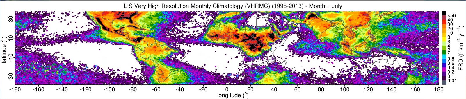
Sample browse image
-
View information related to this datasetHTML
Collection DOI for set of related datasets
-
View documentation related to this datasetPDF
The guide document contains detailed information about the dataset
-
View the primary investigator's documentation...HTML
Where are the lightning hotspots on Earth?
-
Downloadable software applicationsHTML
LIS Very High Resolution Climatology Data Reader Code
-
The dataset's project home pageHTML
The home page for the project or program which sponsored the dataset
-
Use this dataset in a web based toolHTML
Google Earth Tool
-
View a micro article on this datasetHTML
Highlights from Albrecht et. al's 'Where Are the Lightning Hotspots on...
-
Get a related visualizationHTML
N/A
-
View documentation related to this datasetHTML
Instructions for citing GHRC data
-
Landing PageLanding Page
Dates
| Metadata Created Date | December 1, 2022 |
|---|---|
| Metadata Updated Date | December 6, 2023 |
Metadata Source
- Data.json Data.json Metadata
Harvested from NASA Data.json
Graphic Preview
Additional Metadata
| Resource Type | Dataset |
|---|---|
| Metadata Created Date | December 1, 2022 |
| Metadata Updated Date | December 6, 2023 |
| Publisher | NASA/MSFC/GHRC |
| Maintainer | |
| Identifier | C1979883359-GHRC_DAAC |
| Data First Published | 2016-03-02 |
| Language | en-US |
| Data Last Modified | 2022-04-28 |
| Category | LIS, geospatial |
| Public Access Level | public |
| Bureau Code | 026:00 |
| Metadata Context | https://project-open-data.cio.gov/v1.1/schema/catalog.jsonld |
| Metadata Catalog ID | https://data.nasa.gov/data.json |
| Schema Version | https://project-open-data.cio.gov/v1.1/schema |
| Catalog Describedby | https://project-open-data.cio.gov/v1.1/schema/catalog.json |
| Citation | Albrecht, Rachel I, Steve Goodman, Dennis Buechler, Richard J. Blakeslee and Hugh Christian.2016. LIS 0.1 DEGREE VERY HIGH RESOLUTION GRIDDED LIGHTNING MONTHLY CLIMATOLOGY (VHRMC) indicate subset used. Dataset available online from the NASA Global Hydrometeorology Resource Center DAAC, Huntsville, Alabama, U.S.A. DOI: http://dx.doi.org/10.5067/LIS/LIS/DATA302 |
| Graphic Preview Description | N/A |
| Graphic Preview File | https://ghrc.nsstc.nasa.gov/pub/lis/climatology/LIS/VHRMC/animations/ |
| Harvest Object Id | 12e50c39-7d22-42e2-a400-eca628296e8b |
| Harvest Source Id | 58f92550-7a01-4f00-b1b2-8dc953bd598f |
| Harvest Source Title | NASA Data.json |
| Homepage URL | https://doi.org/10.5067/LIS/LIS/DATA302 |
| Metadata Type | geospatial |
| Old Spatial | -180.0 -38.0 180.0 38.0 |
| Program Code | 026:001 |
| Source Datajson Identifier | True |
| Source Hash | 7bf4c6b86e235c8f242e2d631126ea35b6ca63ed4b08cc8ab0557d9a5a95c384 |
| Source Schema Version | 1.1 |
| Spatial | |
| Temporal | 1998-01-01T00:00:00Z/2013-12-31T23:59:59Z |
Didn't find what you're looking for? Suggest a dataset here.