
-
Federal
Compendium of Environmental Sustainability Indicator Collections: Complete Collection, Version 1.1
National Aeronautics and Space Administration —
The Compendium of Environmental Sustainability Indicator Collections, Version 1.1 contains 426 indicators for 239 countries from five major environmental... -
Federal
2005 Environmental Sustainability Index (ESI)
National Aeronautics and Space Administration —
The 2005 Environmental Sustainability Index (ESI) is a measure of overall progress towards environmental sustainability, developed for 146 countries. The index... -
Federal
SDG Indicator 11.2.1: Urban Access to Public Transport, 2023 Release
National Aeronautics and Space Administration —
The SDG Indicator 11.2.1: Urban Access to Public Transport, 2023 Release, part of the SDGI collection, measures the proportion of the population in a city that has... -
Federal
Flight Crew Physiological Data for Crew State Monitoring
National Aeronautics and Space Administration —
This physiological data was collected from pilot/copilot pairs in and out of a flight simulator. It was collected to train machine-learning models to aid in the... -
Federal
Dar es Salaam Land Use and Informal Settlement Data Set
National Aeronautics and Space Administration —
The Dar es Salaam Land Use and Informal Settlement Data Set represents urban land use and consolidation of informal settlements for the years 1982, 1992, 1998, and... -
Federal
Global Landslide Mortality Risks and Distribution
National Aeronautics and Space Administration —
The Global Landslide Mortality Risks and Distribution is a 2.5 minute grid of global landslide mortality risks. Gridded Population of the World, Version 3 (GPWv3)... -
Federal
Global One-Eighth Degree Population Base Year and Projection Grids Based on the Shared Socioeconomic Pathways, Revision 01
National Aeronautics and Space Administration —
The Global One-Eighth Degree Population Base Year and Projection Grids Based on the Shared Socioeconomic Pathways, Revision 01, data set consists of global urban,... -
Federal
Global Drought Proportional Economic Loss Risk Deciles
National Aeronautics and Space Administration —
The Global Drought Proportional Economic Loss Risk Deciles is a 2.5 minute grid of drought hazard economic loss as proportions of Gross Domestic Product (GDP) per... -
Federal
Archive of Census Related Products (ACRP): 1992 Boundary Files
National Aeronautics and Space Administration —
The 1992 Boundary Files portion of the Archive of Census Related Products (ACRP) consists of 1992 boundary data from the U.S. Census Bureau's Topologically Integrated... -
Federal
USGS Global Forest Observations Initiative (GFOI) Colombia
National Aeronautics and Space Administration —
The Global Forest Observations Initiative (GFOI) is an initiative of the inter-governmental Group on Earth Observations (GEO) that aims to: foster the sustained... -
Federal
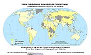
Synthetic Assessment of Global Distribution of Vulnerability to Climate Change: Maps and Data, 2005, 2050, and 2100
National Aeronautics and Space Administration —
The Synthetic Assessment of Global Distribution of Vulnerability to Climate Change: Maps and Data, 2005, 2050, and 2100 data set consist of maps and vulnerability... -
Federal
Global 15 x 15 Minute Grids of the Downscaled Population Based on the SRES B2 Scenario, 1990 and 2025
National Aeronautics and Space Administration —
The Global 15x15 Minute Grids of the Downscaled Population Based on the Special Report on Emissions Scenarios (SRES) B2 Scenario, 1990 and 2025, are geospatial... -
Federal
Poverty Mapping Project: Global Subnational Prevalence of Child Malnutrition
National Aeronautics and Space Administration —
The Poverty Mapping Project: Global Subnational Prevalence of Child Malnutrition data set consists of estimates of the percentage of children with weight-for-age... -
Federal
Low Elevation Coastal Zone (LECZ) Urban-Rural Population and Land Area Estimates, Version 3
National Aeronautics and Space Administration —
The Low Elevation Coastal Zone (LECZ) Urban-Rural Population and Land Area Estimates, Version 3 data set contains land areas with urban, quasi-urban, rural, and total... -
Federal
Population Exposure Estimates in Proximity to Nuclear Power Plants, Locations
National Aeronautics and Space Administration —
The Population Exposure Estimates in Proximity to Nuclear Power Plants, Locations data set combines information from a global data set developed by Declan Butler of... -
Federal
Gridded Population of the World, Version 4 (GPWv4): Population Density Adjusted to Match 2015 Revision UN WPP Country Totals, Revision 11
National Aeronautics and Space Administration —
The Gridded Population of the World, Version 4 (GPWv4): Population Density Adjusted to Match 2015 Revision of UN WPP Country Totals, Revision 11 consists of estimates... -
Federal
Global Earthquake Hazard Distribution - Peak Ground Acceleration
National Aeronautics and Space Administration —
The Global Earthquake Hazard Distribution - Peak Ground Acceleration is a 2.5 minute grid of global earthquake hazards developed using Global Seismic Hazard Program... -
Federal
SDG Indicator 9.1.1: Rural Access Index (RAI), 2023 Release
National Aeronautics and Space Administration —
The SDG Indicator 9.1.1: The Rural Access Index (RAI), 2023 Release data set, part of the SDGI collection, measures the proportion of the rural population who live... -
Federal
Food Insecurity Hotspots Data Set
National Aeronautics and Space Administration —
The Food Insecurity Hotspots Data Set consists of grids at 250 meter (~7.2 arc-seconds) resolution that identify the level of intensity and frequency of food...

Official websites use .gov
A
.gov website belongs to an official government
organization in the United States.
Secure .gov websites use HTTPS
A
lock (
) or https:// means you’ve safely connected to
the .gov website. Share sensitive information only on official,
secure websites.