
-
Federal
Terrestrial Condition Assessment (TCA) Fire Deficit
Department of Agriculture —
Direct Download (Raster Data Gateway)Objective: Identify ecosystems that have a significant proportion of their area burning less frequently than what occurred under... -
Federal
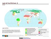
Last of the Wild Project, Version 2, 2005 (LWP-2): Global Human Footprint Dataset (Geographic)
National Aeronautics and Space Administration —
The Global Human Footprint Dataset of the Last of the Wild Project, Version 2, 2005 (LWP-2) is the Human Influence Index (HII) normalized by biome and realm. The HII... -
Federal
Savannah CTD, SAV1803, SAV1803_SAV1803_33, 2018-03-11, 25.9122N 81.7992W
National Oceanic and Atmospheric Administration, Department of Commerce —
Savannah Conductivity, Temperature, Depth (CTD) - SAV1803 - SAV1803_SAV1803_33 - 2018-03-11 - 25.9122N 81.7992W. Hydrographic Measurements in the Gulf of Mexico.... -
Federal
EM122 Water Column Sonar Data Collected During AT26-04
National Oceanic and Atmospheric Administration, Department of Commerce —
Thermal Structure of the Cascadia Subduction Zone on the Washington Margin (AT26-04, EM122). We propose to conduct a comprehensive study of the thermal environment of... -
Federal
Probabilistic Wildfire Risk (Map Service)
Department of Agriculture —
National burn probability (BP) and conditional fire intensity level (FIL) data were generated for the conterminous United States (US) using a geospatial Fire... -
Federal
Traits and Factors Catalog (TRAFAC): Non-native insects of North American forests
Department of the Interior —
These data were compiled in support of the "Predicting the next high-impact insect invasion: Elucidating traits and factors determining the risk of introduced... -
Federal
Last of the Wild Project, Version 2, 2005 (LWP-2): Last of the Wild Dataset (Geographic)
National Aeronautics and Space Administration —
The Last of the Wild Dataset of the Last of the Wild Project, Version 2, 2005 (LWP-2) is derived from the LWP-2 Human Footprint Dataset. The gridded data are... -
Federal
National Estuarine Research Reserve System - NERRS - Meteorological Data
National Oceanic and Atmospheric Administration, Department of Commerce —
Meteorological data provide information on atmospheric conditions that can affect water quality and biological and physical processes. Core elements currently... -
Federal
Walton-Smith CTD, WS18285, WS18285_WS18285_Stn.RP3, 2018-10-15, 26.5502N 82.3313W
National Oceanic and Atmospheric Administration, Department of Commerce —
Walton-Smith Conductivity, Temperature, Depth (CTD) - WS18285 - WS18285_WS18285_Stn.RP3 - 2018-10-15 - 26.5502N 82.3313W. Hydrographic Measurements in the Gulf of... -
Federal
Walton-Smith CTD, WS16004, WS16004_Sta64, 2016-01-06, 25.1663N 81.1563W
National Oceanic and Atmospheric Administration, Department of Commerce —
Walton-Smith Conductivity, Temperature, Depth (CTD) - WS16004 - WS16004_Sta64 - 2016-01-06 - 25.1663N 81.1563W. Hydrographic Measurements in the Gulf of Mexico.... -
Federal
World Terrestrial Ecosystems (WTE) 2020 NGDA
Department of the Interior —
The World Terrestrial Ecosystems datalayer is a global raster dataset at a 250 m spatial resolution where 431 ecosystem types are identified and mapped. Each... -
Federal
Coastal Bend Texas Benthic Habitat Mapping Patchy Shapefile Map - San Antonio Bay and Espiritu Santo Bay
National Oceanic and Atmospheric Administration, Department of Commerce —
The NOAA Office for Coastal Management (OCM) requested the creation of benthic habitat data along the southern Texas coast to support the Texas Seagrass Monitoring... -
Federal
National Coral Reef Monitoring Program: Shallow Water and Offshore Conductivity-Temperature-Depth (CTD) Profiles for select coral reef locations across the Hawaiian Archipelago since 2013
National Oceanic and Atmospheric Administration, Department of Commerce —
Nearshore and offshore Conductivity-Temperature-Depth (CTD) casts were collected at sites in the Hawaiian Archipelago as part of the National Coral Reef Monitoring... -
Federal
National Coral Reef Monitoring Program: Assessment of coral reef fish communities in Puerto Rico from 2021-04-29 to 2021-12-24 (NCEI Accession 0276281)
National Oceanic and Atmospheric Administration, Department of Commerce —
The National Coral Reef Monitoring Program (NCRMP) assessed coral reef fish communities around Puerto Rico using the stationary point count method (7.5m radius... -
Federal
EK60 Water Column Sonar Data Collected During AL0409
National Oceanic and Atmospheric Administration, Department of Commerce —
NEFSC 2004 Fall Bottom Trawl Survey (AL0409, EK500). The NEFSC bottom trawl survey is a fisheries independent, multi-species survey that provides the primary... -
Federal
Walton-Smith CTD, WS1106, WS1106_WS1106_068, 2011-04-05, 24.928N 81.1658W
National Oceanic and Atmospheric Administration, Department of Commerce —
Walton-Smith Conductivity, Temperature, Depth (CTD) - WS1106 - WS1106_WS1106_068 - 2011-04-05 - 24.928N 81.1658W. Hydrographic Measurements in the Gulf of Mexico.... -
Federal
Walton-Smith CTD, WS22281, WS22281_Stn031, 2022-10-10, 25.7403N 81.9447W
National Oceanic and Atmospheric Administration, Department of Commerce —
Walton-Smith Conductivity, Temperature, Depth (CTD) - WS22281 - WS22281_Stn031 - 2022-10-10 - 25.7403N 81.9447W. Hydrographic Measurements in the Gulf of Mexico.... -
Federal
Sediment grab data from October 1995 in the inland bays of New York/New Jersey Harbor
National Oceanic and Atmospheric Administration, Department of Commerce —
Sediment grab samples were collected using a Shipek grab at pre-determined locations in the harbor. Grain size distributions and organic content were measured and... -
Federal
2004 Benthic Grab Data for Catlett and Goodwin Islands on the York River in Chesapeake Bay, Virginia (Ches_2004benthos)
National Oceanic and Atmospheric Administration, Department of Commerce —
This data set represents the benthic community information gathered from grab sampling in 2004 (12 stations). In Fall/Winter 2002, researchers from the Virginia...

Official websites use .gov
A
.gov website belongs to an official government
organization in the United States.
Secure .gov websites use HTTPS
A
lock (
) or https:// means you’ve safely connected to
the .gov website. Share sensitive information only on official,
secure websites.