
-
Federal
HURRICANE AND SEVERE STORM SENTINEL (HS3) HIGH-ALTITUDE IMAGING WIND AND RAIN AIRBORNE PROFILER (HIWRAP) V1 recent views
National Aeronautics and Space Administration —
The Hurricane and Severe Storm Sentinel (HS3) High-Altitude Imaging Wind and Rain dataset was collected from the High-altitude Imaging Wind and Rain Airborne Profiler... -
Federal
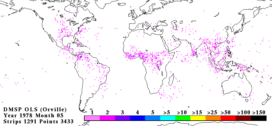
OLS ANALOG DERIVED LIGHTNING V1 recent views
National Aeronautics and Space Administration —
The OLS Analog Derived Lightning dataset consists of global lightning signatures from the Defense Meteorological Satellite Program (DMSP) Operational Linescan System... -
Federal
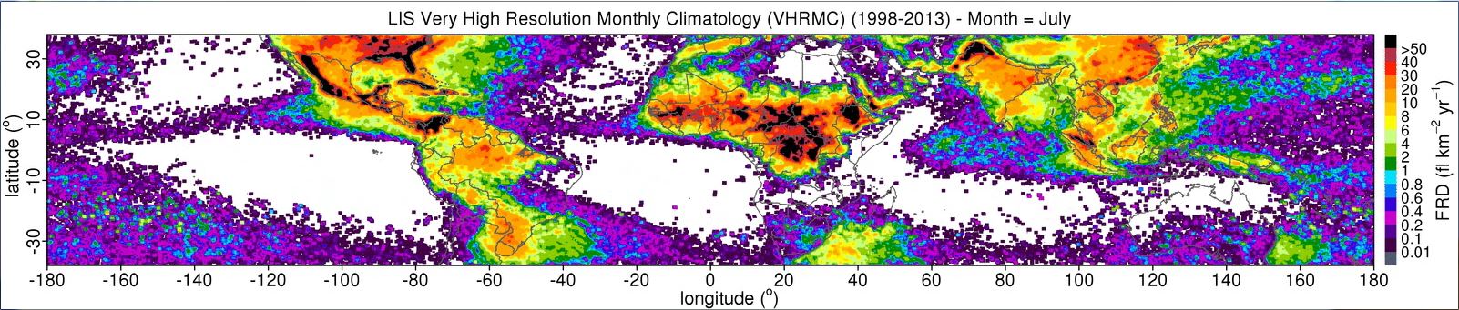
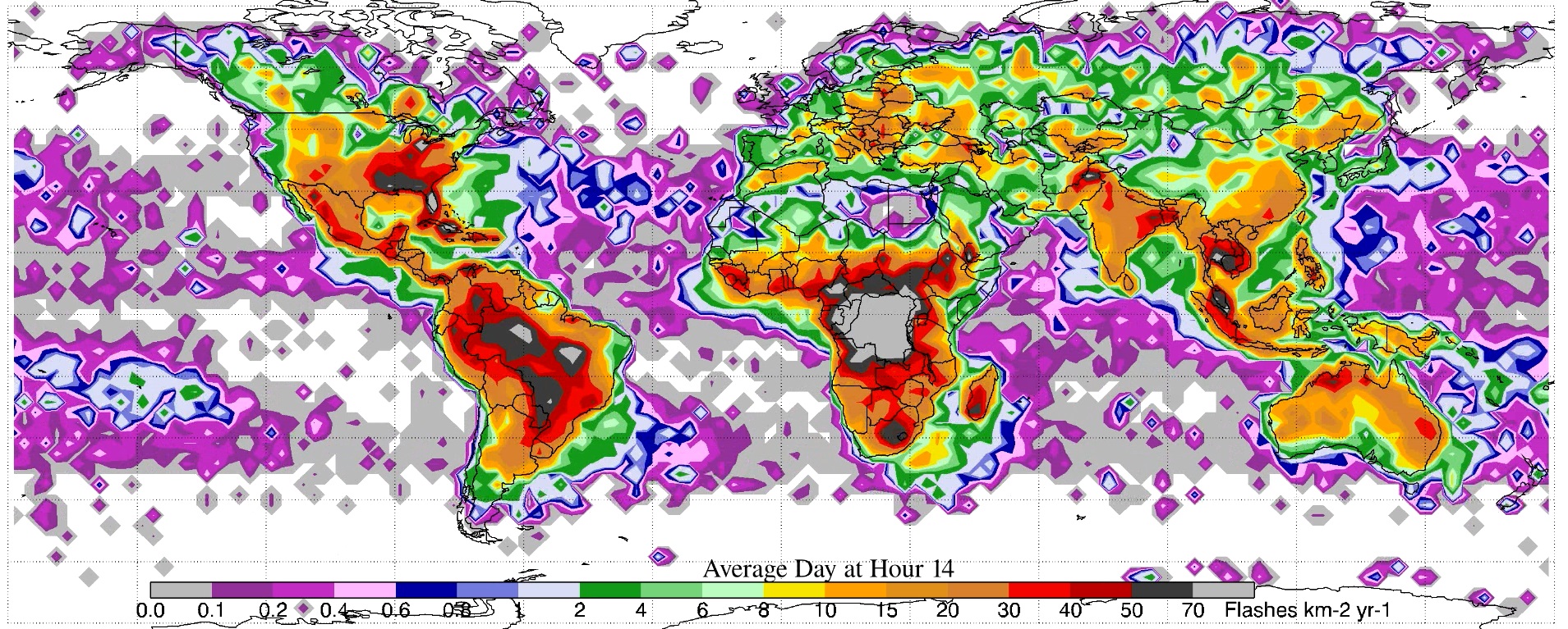
LIS 0.1 DEGREE VERY HIGH RESOLUTION GRIDDED LIGHTNING MONTHLY CLIMATOLOGY (VHRMC) V1 recent views
National Aeronautics and Space Administration —
The LIS 0.1 Degree Very High Resolution Gridded Lightning Monthly Climatology (VHRMC) dataset consists of gridded monthly climatologies of total lightning flash rates... -
Federal
GOES-R PLT Mission Reports V1 recent views
National Aeronautics and Space Administration —
The GOES-R PLT Mission Reports dataset consists of various reports filed by the scientists during the GOES-R Post Launch Test (PLT) field campaign including flight... -
Federal
LBA-ECO CD-05 Forest Understory Fuel Loads, Paragominas, Para, Brazil: 2001 recent views
National Aeronautics and Space Administration —
This data set contains estimates of understory fuel loads (forest litter) at six locations near Paragominas in Northeastern Amazonia. Samples were collected from... -
Federal
SEAC4RS Analysis and Ancillary Data recent views
National Aeronautics and Space Administration —
SEAC4RS_Analysis_Data are ancillary analysis data utilized as part of the Studies of Emissions and Atmospheric Composition, Clouds and Climate Coupling by Regional... -
Federal
SASS (Subsonics Assessment) Ozone and NOx Experiment (SONEX) Supplementary Data recent views
National Aeronautics and Space Administration —
SONEX_Other_Data_1 is the supplementary datasets for the SONEx suborbital campaign. Included in this product are images from the National Lightning Data Network... -
Federal
SASS (Subsonics Assessment) Ozone and NOx Experiment (SONEX) Ancillary Data recent views
National Aeronautics and Space Administration —
SONEX_Miscellaneous_Data_1 is the ancillary datasets from the SASS (Subsonics Assessment) Ozone and NOx Experiment (SONEX). This dataset contains gif and postscript... -
Federal
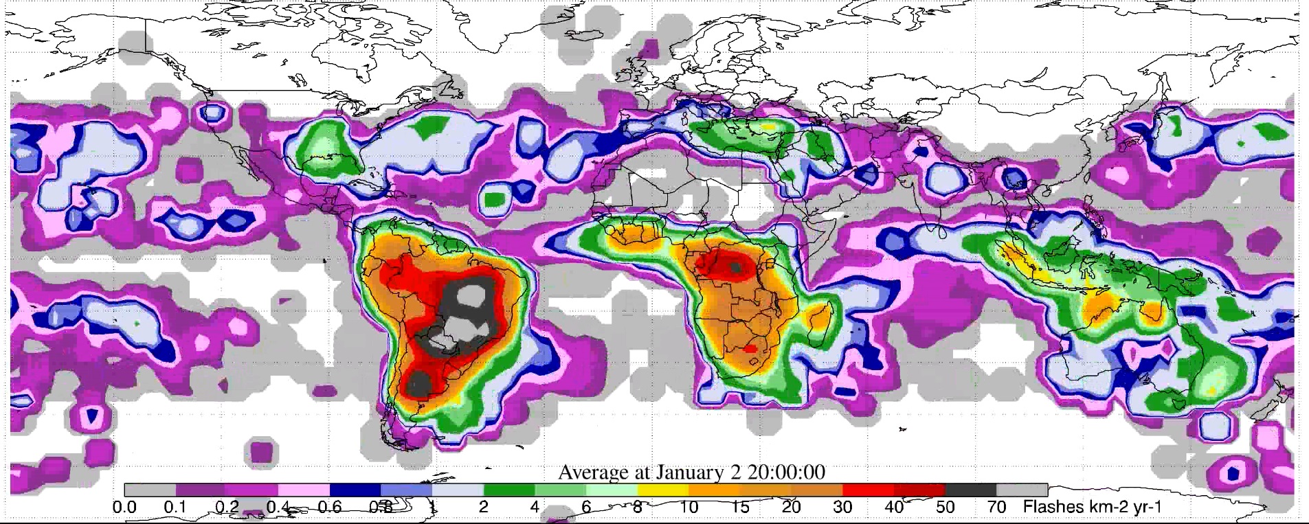
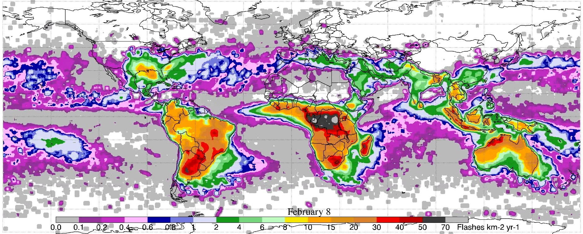
LIS/OTD 2.5 Degree Low Resolution Annual Diurnal Climatology (LRADC) V2.3.2015 recent views
National Aeronautics and Space Administration —
The LIS/OTD 2.5 Degree Low Resolution Annual Dirunal Climatology (LRADC) contains a variety of gridded climatologies of total lightning flash rates obtained from two... -
Federal
Co-Registered AMSR-E, QuikSCAT, and WMO Data, Version 1 recent views
National Aeronautics and Space Administration —
Notice to Data Users: The documentation for this data set was provided solely by the Principal Investigator(s) and was not further developed, thoroughly reviewed, or... -
Federal
Global 10-Year Mean Monthly Climatology, 1901-1990 (New et al.) recent views
National Aeronautics and Space Administration —
A data set of decade-mean monthly surface climate over global land areas, excluding Antarctica. Interpolated from station data to 0.5 degree lat/lon for a range of... -
Federal
CALIPSO Lidar Level 2 Blowing Snow - Antarctica, V2-00 recent views
National Aeronautics and Space Administration —
CAL_LID_L2_BlowingSnow_Antarctica-Standard-V2-00 is the Cloud-Aerosol Lidar and Infrared Pathfinder Satellite Observations (CALIPSO) Lidar Level 2 Blowing Snow -... -
Federal
CALIPSO Lidar Level 2 Blowing Snow - Greenland, V1-00 recent views
National Aeronautics and Space Administration —
CAL_LID_L2_BlowingSnow_Greenland-Standard-V1-00 is the Cloud-Aerosol Lidar and Infrared Pathfinder Satellite Observations (CALIPSO) Lidar Level 2 Blowing Snow -... -
Federal
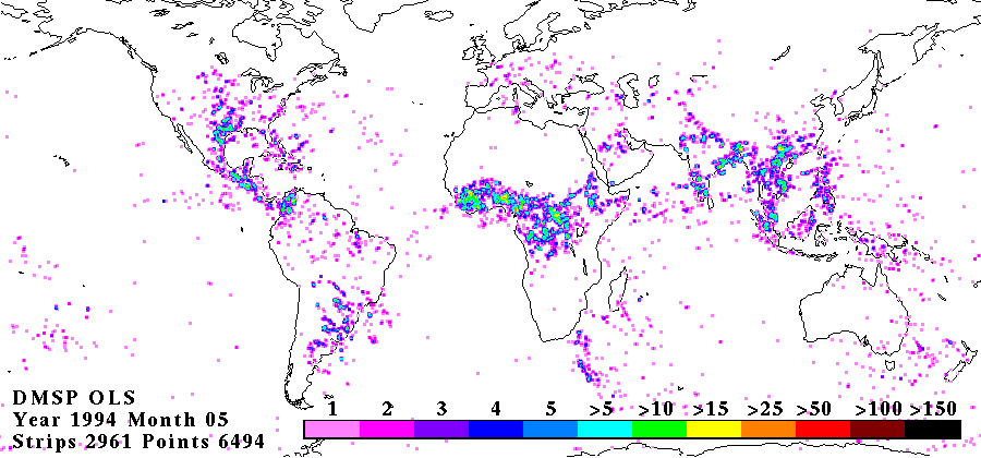
OLS DIGITAL DERIVED LIGHTNING FROM DMSP F10 V1 recent views
National Aeronautics and Space Administration —
The OLS Digital Derived Lightning from DMSP F10 dataset consists of global lightning signatures from the Defense Meteorological Satellite Program (DMSP) Operational... -
Federal
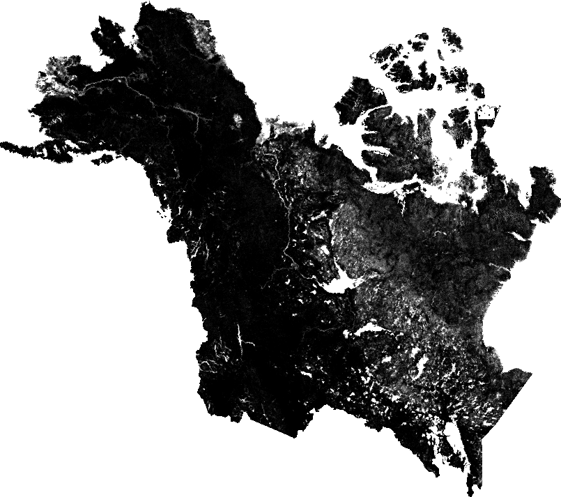
ABoVE: Fractional Open Water Cover for Pan-Arctic and ABoVE-Domain Regions, 2002-2015 NGDA recent views
National Aeronautics and Space Administration —
This data set provides land surface fractional open water cover maps for two overlapping regions: the entire pan-Arctic region (latitude > 45 degrees) and the... -
Federal
LIS/OTD 2.5 Degree Low Resolution Diurnal Climatology (LRDC) V2.3.2015 recent views
National Aeronautics and Space Administration —
The LIS/OTD 2.5 Degree Low Resolution Diurnal Climatology (LRDC) contains a variety of gridded climatologies of total lightning flash rates obtained from two... -
Federal
LIS/OTD 0.5 Degree High Resolution Annual Climatology (HRAC) V2.3.2015 recent views
National Aeronautics and Space Administration —
The LIS/OTD 0.5 Degree High Resolution Annual Climatology (HRAC) contains a variety of gridded climatologies of total lightning flash rates obtained from two...

Official websites use .gov
A
.gov website belongs to an official government
organization in the United States.
Secure .gov websites use HTTPS
A
lock (
) or https:// means you’ve safely connected to
the .gov website. Share sensitive information only on official,
secure websites.