
-
Federal
Latin America and the Caribbean Population Time Series
National Aeronautics and Space Administration —
The Latin America and the Caribbean Population Time Series data set provides total population estimates using spatially consistent and comparable Units for Latin... -
Federal
MODIS/Terra+Aqua Direct Broadcast Burned Area Monthly L3 Global 500m SIN Grid V061 NGDA
National Aeronautics and Space Administration —
The Terra and Aqua combined MCD64A1 Version 6.1 Burned Area data product is a monthly, global gridded 500 meter (m) product containing per-pixel burned-area and... -
Federal
Archive of Census Related Products (ACRP): 1990 ZIP Equivalency Files
National Aeronautics and Space Administration —
The 1990 Zip Equivalency Files portion of the Archive of Census Related Products (ACRP) contains population and housing data derived from the U.S. Census Bureau's... -
Federal
Sentinel-3A OLCI Global Mapped CyAN Project, True Color (TC) - Near Real-Time (NRT) Data, version 5.0
National Aeronautics and Space Administration —
The Ocean Biology DAAC produces near real-time (quicklook) products using the best-available combination of ancillary data from meteorological and ozone data. As... -
Federal
Sentinel-3B OLCI Global Mapped CyAN Project, True Color (TC) - Near Real-Time (NRT) Data, version 5.0
National Aeronautics and Space Administration —
The Ocean Biology DAAC produces near real-time (quicklook) products using the best-available combination of ancillary data from meteorological and ozone data. As... -
Federal
NAFD-ATT Forest Canopy Cover Loss from Landsat, CONUS, 1986-2010
National Aeronautics and Space Administration —
Characterizing the cause of forest canopy changes through time is fundamental to understanding current and future forest functions. A better understanding of forest... -
Federal
ABoVE: Environmental Conditions and Subsistence Resource Access, Alaska, 2016-2017
National Aeronautics and Space Administration —
This dataset provides descriptions and photos of environmental conditions that impacted availability to subsistence resources by residents in nine rural communities... -
Federal
China Dimensions Data Collection: Chinese County-Level Data on Hospitals and Epidemiology Stations, 1950-1985
National Aeronautics and Space Administration —
The China Dimensions Data Collection: Chinese County-Level Data on Hospitals and Epidemiology Stations, 1950-1985 consists of hospital and epidemiological station... -
Federal
Net Radiation and Albedo from MODIS for Xingu River Basin, Brazil, 2000-2012 NGDA
National Aeronautics and Space Administration —
This dataset provides daily average land surface net radiation (Rnet) as an 8-day time series at approximately 0.5 km resolution for the upper Xingu River Basin in... -
Federal
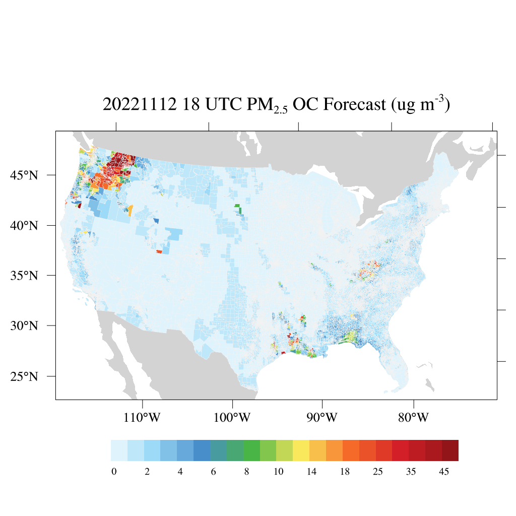
HAQES 3-Hourly Ensemble mean surface PM2.5 Organic Carbon concentration at census level, North America V1 (HAQES_NA_PM25_OC_CENSUS) at GES DISC
National Aeronautics and Space Administration —
This product provides HAQES 3-hourly ensemble mean surface PM2.5 Organic Carbon concentration at the census level over the continental United States (CONUS). The... -
Federal
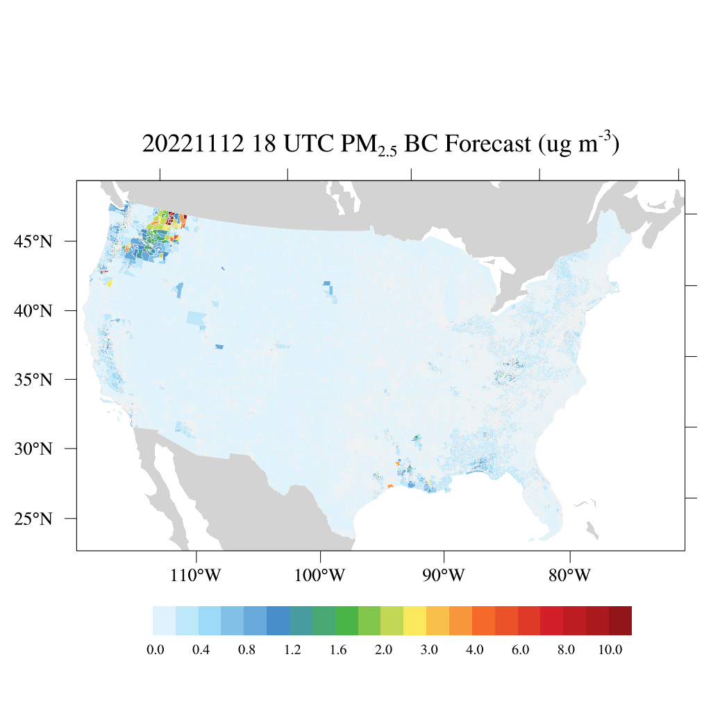
HAQES 3-Hourly Ensemble mean surface PM2.5 Black Carbon concentration at census level, North America V1 (HAQES_NA_PM25_BC_CENSUS) at GES DISC
National Aeronautics and Space Administration —
This product provides HAQES 3-hourly ensemble mean surface PM2.5 Black Carbon concentration at the census level over the continental United States (CONUS). The... -
Federal
2001 Environmental Sustainability Index (ESI)
National Aeronautics and Space Administration —
The 2001 Environmental Sustainability Index (ESI) utilizes a refined methodology based on the 2000 Pilot ESI effort, to construct an index covering 122 countries that... -
Federal
2015 Urban Extents from VIIRS and MODIS for the Continental U.S. Using Machine Learning Methods NGDA
National Aeronautics and Space Administration —
The 2015 Urban Extents from VIIRS and MODIS for the Continental U.S. Using Machine Learning Methods data set models urban settlements in the Continental United States... -
Federal
USGS Global Forest Observations Initiative (GFOI) Guatemala
National Aeronautics and Space Administration —
The Global Forest Observations Initiative (GFOI) is an initiative of the inter-governmental Group on Earth Observations (GEO) that aims to: foster the sustained... -
Federal
China Dimensions Data Collection: China County-Level Data on Population (Census) and Agriculture, Keyed to 1:1M GIS Map
National Aeronautics and Space Administration —
The China County-Level Data on Population (Census) and Agriculture, Keyed To 1:1M GIS Map consists of census, agricultural economic, and boundary data for the... -
Federal
China Dimensions Data Collection: GuoBiao (GB) Codes for the Administrative Divisions of the Peoples Republic of China
National Aeronautics and Space Administration —
The GuoBiao (GB) Codes for the Administrative Divisions of the People's Republic of China consists of geographic codes for the administrative divisions of China. The... -
Federal
1:100,000-scale Digital Line Graphs (DLG) from the U.S. Geological Survey
National Aeronautics and Space Administration —
Digital line graph (DLG) data are digital representations of cartographic information. DLG's of map features are converted to digital form from maps and related... -
Federal
Global Landslide Nowcast from LHASA L4 1 day 1 km x 1 km version 1.1 (Global_Landslide_Nowcast) at GES DISC
National Aeronautics and Space Administration —
The Landslide Hazard Analysis for Situational Awareness (LHASA) model identifies locations with high potential for landslide occurrence at a daily temporal...

Official websites use .gov
A
.gov website belongs to an official government
organization in the United States.
Secure .gov websites use HTTPS
A
lock (
) or https:// means you’ve safely connected to
the .gov website. Share sensitive information only on official,
secure websites.