
-
Federal
GLDAS Catchment Land Surface Model L4 daily 0.25 x 0.25 degree GRACE-DA1 V2.2 (GLDAS_CLSM025_DA1_D_EP) at GES DISC recent views
National Aeronautics and Space Administration —
NASA Global Land Data Assimilation System Version 2 (GLDAS-2) has three components: GLDAS-2.0, GLDAS-2.1, and GLDAS-2.2. GLDAS-2.0 is forced entirely with the... -
Federal
MERRA-2 tavg1_2d_lnd_Nx: 2d,1-Hourly,Time-Averaged,Single-Level,Assimilation,Land Surface Diagnostics 0.625 x 0.5 degree V5.12.4 (M2T1NXLND) at GES DISC recent views
National Aeronautics and Space Administration —
M2T1NXLND (or tavg1_2d_lnd_Nx) is an hourly time-averaged 2-dimensional data collection in Modern-Era Retrospective analysis for Research and Applications version 2... -
Federal
MODIS/Terra Clear Sky Radiance 8-Day Composite Daily L3 Global 25km Equal Area NGDA recent views
National Aeronautics and Space Administration —
The MODIS/Terra Clear Sky Radiance 8-Day Composite Daily L3 Global 25km Equal Area (MODCSR_8) product is created from composited MODCSR_D files. Nine clear-sky... -
Federal
CERES Energy Balanced and Filled (EBAF) TOA Monthly means data in netCDF Edition4.2 recent views
National Aeronautics and Space Administration —
CERES_EBAF-TOA_Edition4.2 is the Clouds and the Earth's Radiant Energy System (CERES) Energy Balanced and Filled (EBAF) Top-of-Atmosphere (TOA) Monthly means data in... -
Federal
FLASHFlux Daily Gridded Single Satellite TOA and Surfaces/Clouds data in HDF Version 4A recent views
National Aeronautics and Space Administration —
FLASH_TISA_Terra-Aqua_Version4a is the Fast Longwave And SHortwave Fluxes (FLASHFlux) Daily Gridded Single Satellite Top-of-Atmosphere (TOA) and Surfaces/Clouds data... -
Federal
CERES ERBE-like Monthly Regional Averages NPP FM5 Edition1-CV recent views
National Aeronautics and Space Administration —
CER_ES9_NPP-FM5_Edition1-CV is the Clouds and the Earth's Radiant Energy System (CERES) Earth Radiation Budget Experiment (ERBE)-like Monthly Regional Averages from... -
Federal
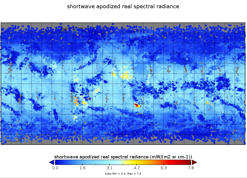
Sounder SIPS: Suomi NPP CrIS Level-1B NSR Calibration Subset: Random full spectra V2 (SNDRSNIL1BCALSUBRNDN) at GES DISC recent views
National Aeronautics and Space Administration —
The CrIS/ATMS instruments used for this product are on board the Suomi National Polar-orbiting Partnership (SNPP) platform and use the Normal Spectral Resolution... -
Federal
GLDAS CLM Land Surface Model L4 3 hourly 1.0 x 1.0 degree Subsetted V001 (GLDAS_CLM10SUBP_3H) at GES DISC recent views
National Aeronautics and Space Administration —
With the upgraded Land Surface Models (LSMs) and updated forcing data sets, the GLDAS version 2.1 (GLDAS-2.1) production stream serves as a replacement for GLDAS-001.... -
Federal
MODIS/Terra Aerosol 5-Min L2 Swath 3km NGDA recent views
National Aeronautics and Space Administration —
The new Collection 6.1 (C61) MODIS/Terra Aerosol 5 Min L2 Swath 3km (MOD04_3K) product is an improved version based on algorithm changes in Dark Target (DT) Aerosol... -
Federal
NACP Site: Tower Meteorology, Flux Observations with Uncertainty, and Ancillary Data recent views
National Aeronautics and Space Administration —
This data set contains meteorological, carbon cycle flux, phenology, and ancillary data measured at 47 eddy covariance flux tower sites across North America. The data... -
Federal
Multi-Radar/Multi-Sensor (MRMS) Precipitation Reanalysis for Satellite Validation Product IMPACTS V1 recent views
National Aeronautics and Space Administration —
The Multi-Radar/Multi-Sensor (MRMS) Precipitation Reanalysis for Satellite Validation Product IMPACTS dataset contains reflectivity products using the MRMS system... -
Federal
MERRA-2 tavg3_3d_rad_Np: 3d,3-Hourly,Time-Averaged,Pressure-Level,Assimilation,Radiation Diagnostics 0.625 x 0.5 degree V5.12.4 (M2T3NPRAD) at GES DISC recent views
National Aeronautics and Space Administration —
M2T3NPRAD (or tavg3_3d_rad_Np) is a 3-dimensional 3-hourly time averaged data collection in Modern-Era Retrospective analysis for Research and Applications version 2... -
Federal
Global Forest Ecosystem Structure and Function Data For Carbon Balance Research recent views
National Aeronautics and Space Administration —
A comprehensive global database has been assembled to quantify CO2 fluxes and pathways across different levels of integration (from photosynthesis up to net ecosystem... -
Federal
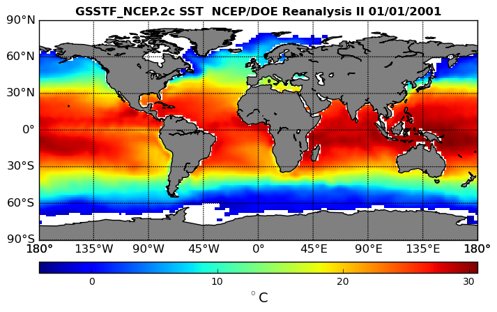
NCEP/DOE Reanalysis II, for GSSTF, 0.25 x 0.25 deg, Daily Grid V3 (GSSTF_NCEP) at GES DISC recent views
National Aeronautics and Space Administration —
These data are the Goddard Satellite-based Surface Turbulent Fluxes Version 3 Dataset recently produced through a MEaSURES funded project led by Dr. Chung-Lin Shie... -
Federal
MODIS/Terra Clouds 5-Min L2 Swath 1km and 5km - NRT NGDA recent views
National Aeronautics and Space Administration —
The level-2 MODIS cloud product consists of cloud optical and physical parameters. These parameters are derived using remotely sensed infrared, visible and near... -
Federal
MODIS/Aqua Clouds 5-Min L2 Swath 1km and 5km NGDA recent views
National Aeronautics and Space Administration —
The MODIS/Aqua Clouds 5-Min L2 Swath 1km and 5km product consists of cloud optical and physical parameters. The cloud optical parameters are generated at 1km and... -
Federal
BOREAS AFM-08 ECMWF Hourly Surface and Upper Air Data for the SSA and NSA recent views
National Aeronautics and Space Administration —
Hourly data from the ECMWF operational model from below the surface to the top of the atmosphere, including the model fluxes at the surface, at Candle Lake,... -
Federal
GLDAS Noah Land Surface Model L4 monthly 1.0 x 1.0 degree V2.0 (GLDAS_NOAH10_M) at GES DISC recent views
National Aeronautics and Space Administration —
NASA Global Land Data Assimilation System Version 2 (GLDAS-2) has three components: GLDAS-2.0, GLDAS-2.1, and GLDAS-2.2. GLDAS-2.0 is forced entirely with the... -
Federal
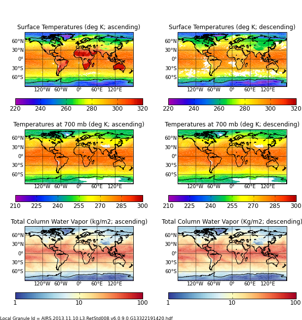
AIRS/Aqua L3 8-day Standard Physical Retrieval (AIRS-only) 1 degree X 1 degree V006 (AIRS3ST8) at GES DISC recent views
National Aeronautics and Space Administration —
The Atmospheric Infrared Sounder (AIRS) is a grating spectrometer (R = 1200) aboard the second Earth Observing System (EOS) polar-orbiting platform, EOS Aqua. In... -
Federal
CERES and GEO-Enhanced TOA, Within-Atmosphere and Surface Fluxes, Clouds and Aerosols Monthly-Averaged 1-Hourly Terra Edition4A NGDA recent views
National Aeronautics and Space Administration —
CER_SYN1deg-MHour_Terra-MODIS_Edition4A is the Clouds and the Earth's Radiant Energy System (CERES) and geostationary (GEO)-Enhanced Top-of-Atmosphere (TOA), Within-...

Official websites use .gov
A
.gov website belongs to an official government
organization in the United States.
Secure .gov websites use HTTPS
A
lock (
) or https:// means you’ve safely connected to
the .gov website. Share sensitive information only on official,
secure websites.