
-
Federal
Shoreline Data Rescue Project of Chesapeake Bay, MD, EC9E05 NGDA
National Oceanic and Atmospheric Administration, Department of Commerce —
These data were automated to provide an accurate high-resolution historical shoreline of Chesapeake Bay, MD suitable as a geographic information system (GIS) data... -
Federal
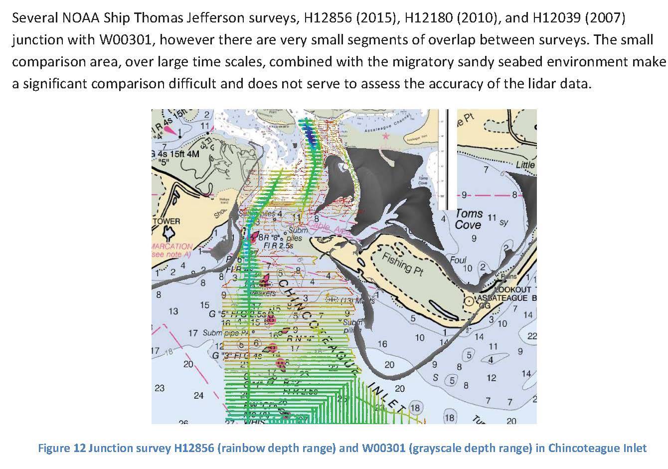
W00327: NOS Hydrographic Survey , 2014-07-01
National Oceanic and Atmospheric Administration, Department of Commerce —
The National Oceanic and Atmospheric Administration (NOAA) has the statutory mandate to collect hydrographic data in support of nautical chart compilation for safe... -
Federal
2017 NOAA NGS Ortho-rectified Near Infrared Mosaic of St. Jeromes Creek, MD
National Oceanic and Atmospheric Administration, Department of Commerce —
This data set contains ortho-rectified mosaic tiles, created as a product from the NOAA Integrated Ocean and Coastal Mapping (IOCM) initiative. The source imagery was... -
Federal
H09321: NOS Hydrographic Survey , Aquila Creek to Liverpool Point, Maryland, 1972-09-08
National Oceanic and Atmospheric Administration, Department of Commerce —
The National Oceanic and Atmospheric Administration (NOAA) has the statutory mandate to collect hydrographic data in support of nautical chart compilation for safe... -
State
MD iMAP: Maryland Watersheds - Chesapeake Bay Watershed
State of Maryland —
This is a MD iMAP hosted service layer. Find more information at http://imap.maryland.gov. Chesapeake Bay Watershed Outline. Defines extent of the Chesapeake Bay... -
Capital Area Food Bank Hunger Estimates
District of Columbia —
Polygons in this layer represent Census Tracts in the DMV (DC, Maryland, and Virginia). Data are included for each tract which estimate hunger and food insecurity.... -
Federal
Shoreline Data Rescue Project of Chesapeake Bay, MD, MD1941A1 NGDA
National Oceanic and Atmospheric Administration, Department of Commerce —
These data were automated to provide an accurate high-resolution historical shoreline of Chesapeake Bay, MD suitable as a geographic information system (GIS) data... -
Federal
H11873: NOS Hydrographic Survey , Mid-Atlantic Corridor, Maryland, 2008-12-18
National Oceanic and Atmospheric Administration, Department of Commerce —
The National Oceanic and Atmospheric Administration (NOAA) has the statutory mandate to collect hydrographic data in support of nautical chart compilation for safe... -
Federal
Medical Expenditure Panel Survey (MEPS) Restricted Data Files
U.S. Department of Health & Human Services —
Restricted Data Files Available at the Data Centers Researchers and users with approved research projects can access restricted data files that have not been publicly... -
Federal
US EPA Nonattainment Areas and Designations-SO2 (2010 NAAQS)
U.S. Environmental Protection Agency —
This web service contains the following layer: SO2 2010 NAAQS State Level. Full FGDC metadata records for each layer may be found by clicking the layer name at the... -
Federal
US EPA Nonattainment Areas and Designations - Download Package
U.S. Environmental Protection Agency —
This downloadable data package contains the following state level layers: Ozone 8-hr (1997 standard), Ozone 8-hr (2008 standard), Lead (2008 standard), SO2 1-hr (2010... -
Federal
Water mass ages based on GLODAPv2 data product (NCEI Accession 0226793)
National Oceanic and Atmospheric Administration, Department of Commerce —
This dataset contain ventilation ages calculated using the transit time distribution (TTD) method (e.g., Waugh et al., 2004) on the GLODAPv2 data synthesis product... -
University
New Mexico County Boundaries (2010 Census)
Earth Data Analysis Center, University of New Mexico —
The TIGER/Line Files are shapefiles and related database files (.dbf) that are an extract of selected geographic and cartographic information from the U.S. Census... -
Federal
MODIS/Terra+Aqua Land Cover Type Yearly L3 Global 500m SIN Grid V061
National Aeronautics and Space Administration —
The Terra and Aqua combined Moderate Resolution Imaging Spectroradiometer (MODIS) Land Cover Type (MCD12Q1) Version 6.1 data product provides global land cover types... -
Federal
Global Ocean Data Analysis Project, Version 2 (GLODAPv2) (NCEI Accession 0162565)
National Oceanic and Atmospheric Administration, Department of Commerce —
This data product is composed of data from 724 scientific cruises covering the global ocean. It includes data assembled during the previous interior ocean data... -
Federal
John H. Chafee Foster Care Program for Successful Transition to Adulthood
U.S. Department of Health & Human Services —
The John H. Chafee Foster Care Program for Successful Transition to Adulthood (the Chafee program) provides funding to support youth/ young adults in or formerly in... -
Federal
Dissolved inorganic carbon (DIC) and total alkalinity (TA) and other hydrographic and chemical data collected from discrete sample and profile observations during the R/V Sikuliaq cruise SKQ202412s (EXPOCODE 33BI20240807) in the Bering and Chukchi Sea along transect lines in the Distributed Biological Observatory (DBO) from 2024-08-07 to 2024-08-26 (NCEI Accession 0304116)
National Oceanic and Atmospheric Administration, Department of Commerce —
This dataset includes hydrographic and chemical data collected from discrete sample and profile observations during the R/V Sikuliaq cruise SKQ202412s (EXPOCODE... -
Federal
US EPA Nonattainment Areas and Designations-8 Hour Ozone (1997 NAAQS)
U.S. Environmental Protection Agency —
This web service contains the following layers: Ozone 1997 NAAQS NAA State Level and Ozone 1997 NAAQS NAA National Level. Full FGDC metadata records for each layer... -
Federal
US EPA Nonattainment Areas and Designations-Annual PM2.5 (2012 NAAQS)
U.S. Environmental Protection Agency —
This web service contains the following layer: PM2.5 Annual 2012 NAAQS State Level. Full FGDC metadata records for each layer may be found by clicking the layer name... -
Federal
BLM Natl MLRS Oil and Gas Participating Areas
Department of the Interior —
This dataset contains oil and gas participating area cases derived from Legal Land Descriptions (LLD) contained in the US Bureau of Land Management's, BLM, Mineral...

Official websites use .gov
A
.gov website belongs to an official government
organization in the United States.
Secure .gov websites use HTTPS
A
lock (
) or https:// means you’ve safely connected to
the .gov website. Share sensitive information only on official,
secure websites.