
-
Federal
NACP Site: Terrestrial Biosphere Model and Aggregated Flux Data in Standard Format
National Aeronautics and Space Administration —
This data set provides standardized output variables for gross primary productivity (GPP), net ecosystem exchange (NEE), leaf area index (LAI), ecosystem respiration... -
Federal
ABoVE: Climate Drivers of Pan-Arctic Tundra Vegetation Productivity, 1982-2015
National Aeronautics and Space Administration —
This dataset provides a summary of potential climate drivers of Arctic tundra vegetation productivity that have been compiled for growing seasons from 1982 to 2015.... -
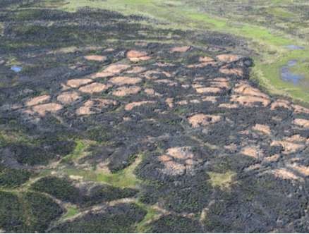
Federal
ABoVE: Post-Fire and Unburned Field Site Data, Anaktuvuk River Fire Area, 2008-2017
National Aeronautics and Space Administration —
This dataset includes field measurements from 26 burned and unburned transects established in 2008 in the region of the Anaktuvuk River tundra fire on the Arctic... -
Federal
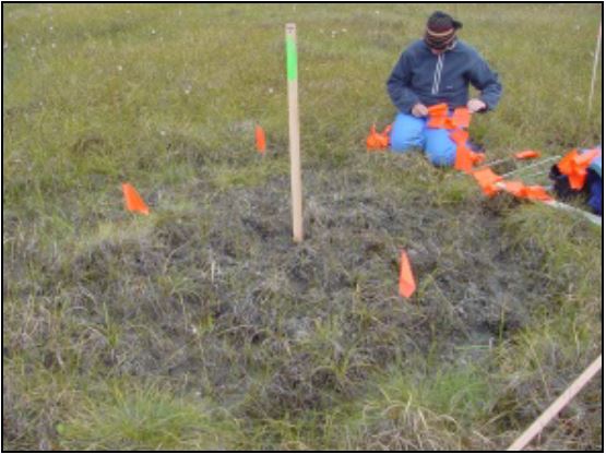
ABoVE: Year-Round Soil CO2 Efflux in Alaskan Ecosystems, Version 2.1
National Aeronautics and Space Administration —
This dataset provides soil-surface carbon dioxide (CO2) efflux derived from measurements of soil respiration with forced diffusion (FD) chambers. Soil Respiration... -
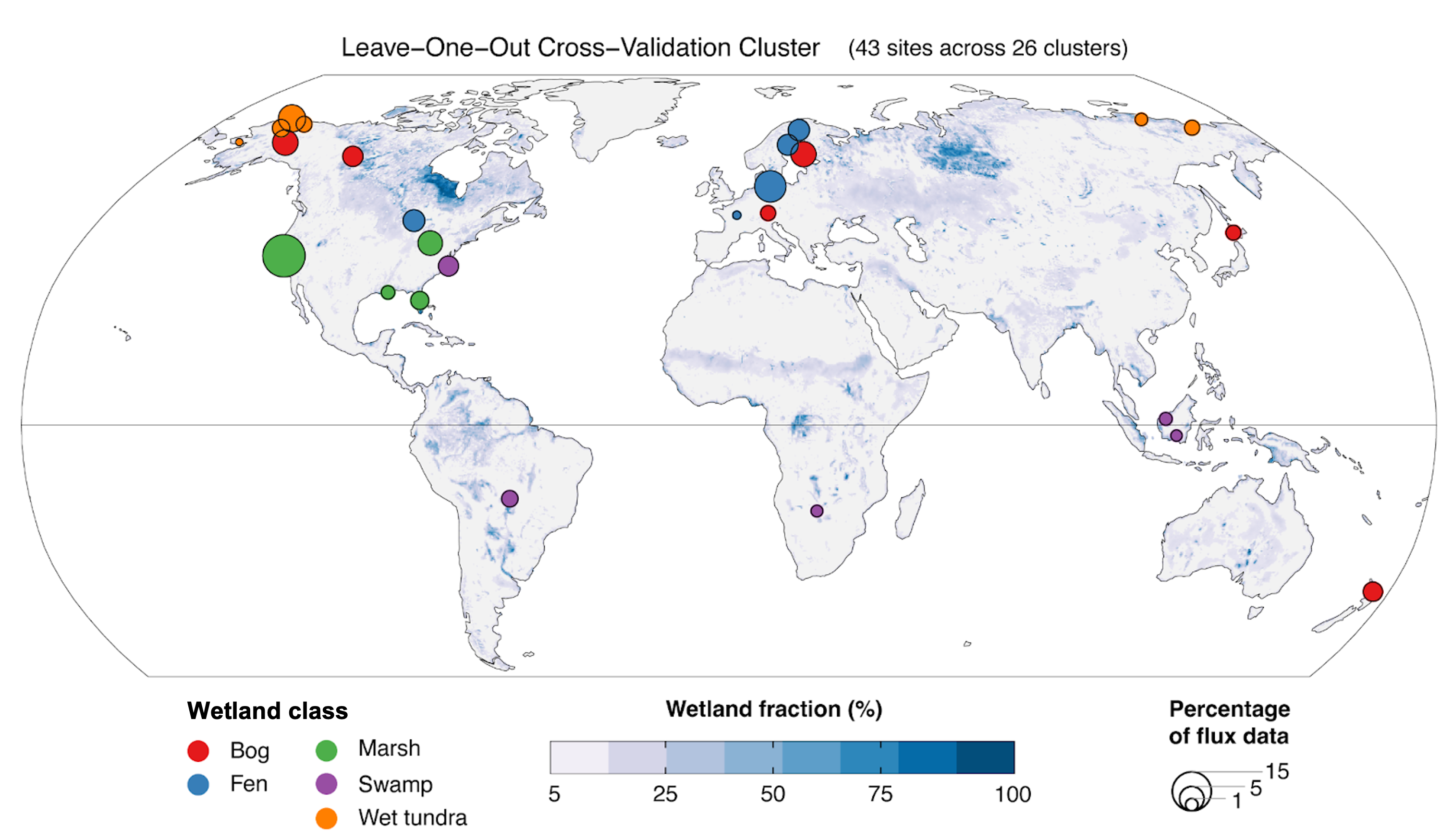
Federal
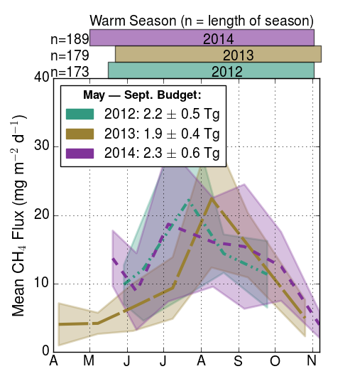
Global Wetland Methane Emissions derived from FLUXNET and the UpCH4 Model, 2001-2018
National Aeronautics and Space Administration —
This dataset provides monthly globally gridded freshwater wetland methane emissions from 2001-2018 in nmol CH4 m-2 s-1, g C-CH4 m-2 d-1, and TgCH4 grid cell-1... -
Federal
ABoVE: Vegetation Composition across Fire History Gradients on the Y-K Delta, Alaska
National Aeronautics and Space Administration —
This dataset provides ecological field data that were collected during July 2017 and July 2018 from 43 plots spanning gradients of fire history in the upland tundra... -
Federal
NPP Boreal Forest: Siberian Scots Pine Forests, Russia, 1968-1974, R1
National Aeronautics and Space Administration —
This data set contains two files (comma-separated-value format). One file provides components of net primary productivity, standing biomass, age and stand structure,... -
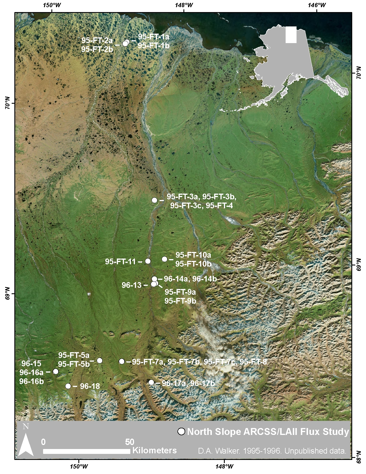
Federal
Arctic Vegetation Plots at ARCSS/LAII Flux Sites, North Slope, Alaska, 1995-1996
National Aeronautics and Space Administration —
This dataset provides vegetation cover and environmental plot and soil data collected at flux tower sites of the North Slope Arctic System Science/Land-Atmosphere-Ice... -
Federal
CARVE: Ecosystem Scale CH4 Emission Derived from Aircraft Observations 2012-2014
National Aeronautics and Space Administration —
This dataset provides methane flux estimates derived from airborne measurements collected over Alaska and the western Yukon Territory during the Carbon in Arctic... -
Federal
Arctic Vegetation Plots at Frost Boil Sites, North Slope, Alaska, 2000-2006
National Aeronautics and Space Administration —
This data set describes the environment, soil, and vegetation on nonsorted circles and earth hummocks at seven study sites along a N-S-transect from the Arctic Ocean... -
Federal
SAFARI 2000 Land Cover from AVHRR, 1-Deg, 1987 (Defries and Townshend)
National Aeronautics and Space Administration —
This data set consists of a southern African subset of the University of Maryland (UMD) 1-degree Global Land Cover product in ASCII GRID and binary image formats. The... -
Federal
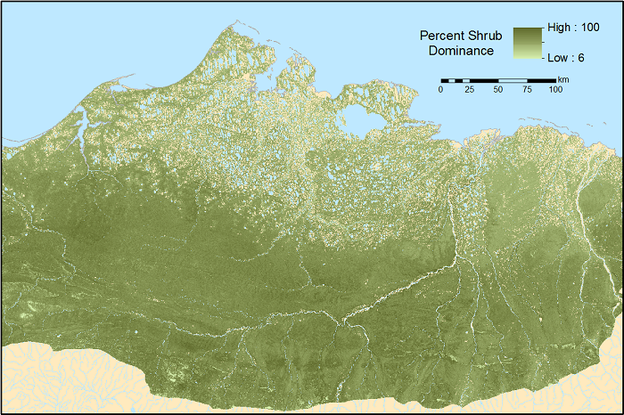
ABoVE: Gridded 30-m Aboveground Biomass, Shrub Dominance, North Slope, AK, 2007-2016
National Aeronautics and Space Administration —
This dataset includes 30-m gridded estimates of total plant aboveground biomass (AGB), the shrub AGB, and the shrub dominance (shrub/plant AGB) for non-water portions... -
Federal
Arctic Vegetation Plots for IBP Tundra Biome, Barrow, Alaska, 1972-2010
National Aeronautics and Space Administration —
This data set provides vegetation cover and environmental plot data collected as part of the International Biological Program (IBP), U. S. Tundra Biome Program, in... -
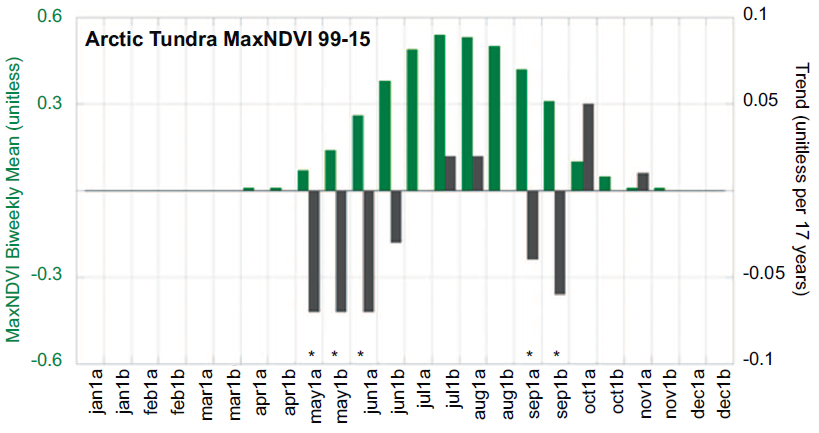
Federal
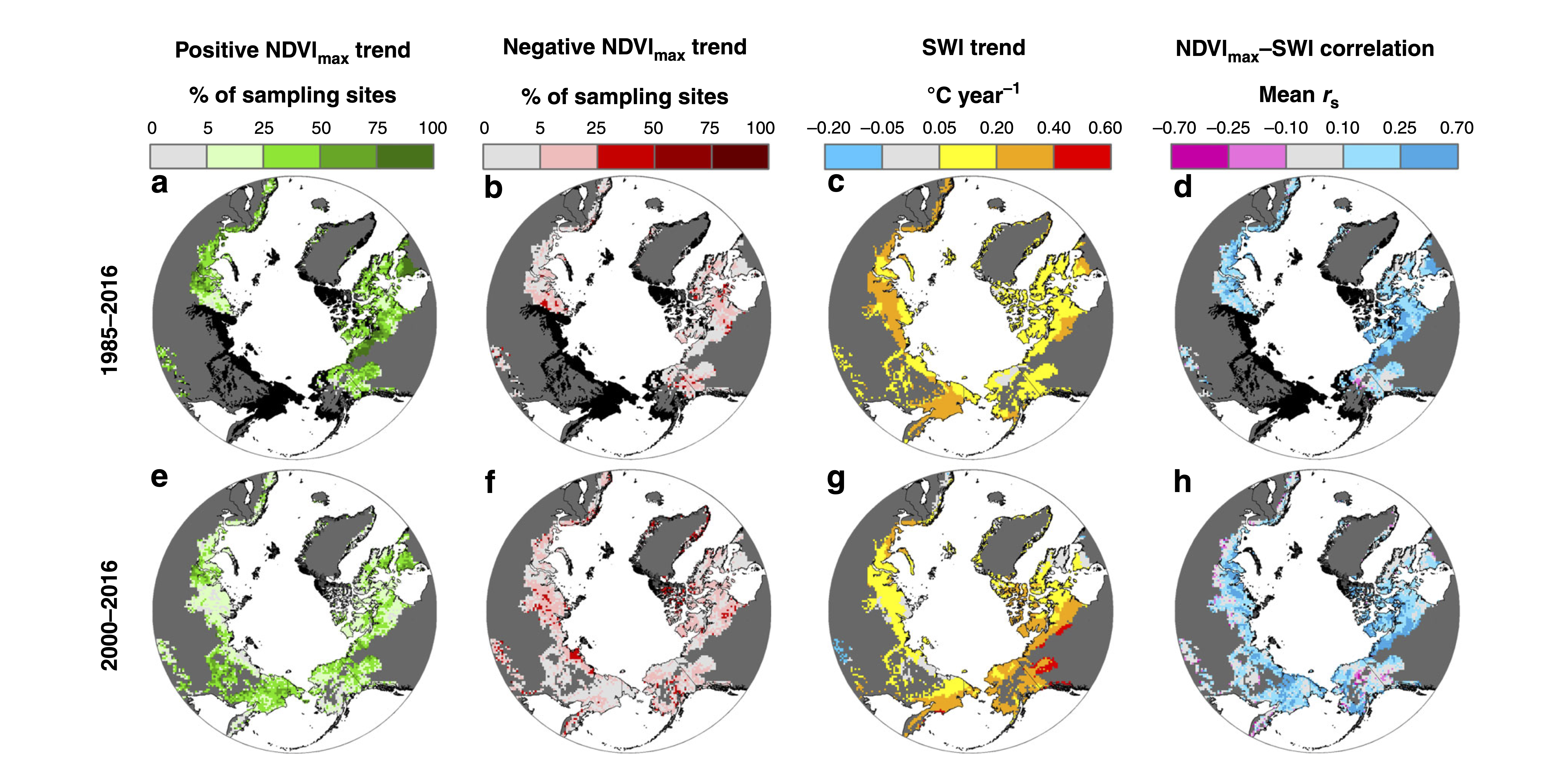
ABoVE: Landsat Tundra Greenness and Summer Air Temperatures, Arctic Tundra, 1985-2016
National Aeronautics and Space Administration —
This dataset provides annual tundra greenness and summer air temperatures at a resolution of 50 km over the pan-Arctic tundra biome above 31.5 degrees over the time... -
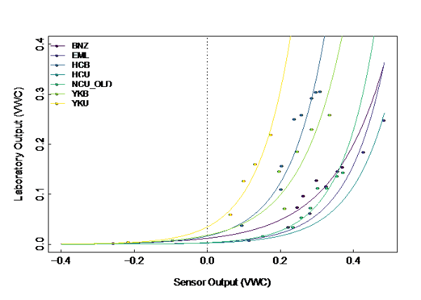
Federal
ABoVE: Soil Temperature and VWC at Unburned and Burned Sites Across Alaska, 2016-2023
National Aeronautics and Space Administration —
This dataset provides soil temperature and volumetric water content (VWC) measurements at 15 cm depth collected at 12 selected boreal and tundra sites located across... -
Federal
NPP Grassland: Consistent Worldwide Site Estimates, 1954-1990, R1
National Aeronautics and Space Administration —
The NPP Database contains documented field measurements of NPP for global terrestrial sites compiled from published literature and other extant data sources. The NPP... -
Federal
Segmentation geospatial data - Land Cover Mapping, North Slope of the Arctic National Wildlife Refuge, Alaska, 2019
Department of the Interior —
"We applied Simple Non-Iterative Clustering (SNIC) (Achanta and Susstrunk 2017) to develop image segments or super-pixels from the WorldView mosaic (Figure 4). Input... -
Federal
Tribal Colleges and Universities (TCU)
Department of the Interior —
Tribal Colleges and Universities (TCUs) are chartered by their respective tribal governments, including the ten tribes within the largest reservations in the United... -
Federal
ABoVE: Distribution Maps of Wildland Fire Fuel Components across Alaskan Tundra, 2015
National Aeronautics and Space Administration —
This dataset provides maps of the distribution of three major wildland fire fuel types at 30 m spatial resolution covering the Alaskan arctic tundra, circa 2015. The... -
Federal
ABoVE: Alder Shrub Cover and Soil Properties, Alaska, 2019, V2
National Aeronautics and Space Administration —
This dataset holds measures of vegetative cover and soil characteristics for sites in interior Alaska, U.S., along the James W. Dalton Highway (Alaska Route 11). The...

Official websites use .gov
A
.gov website belongs to an official government
organization in the United States.
Secure .gov websites use HTTPS
A
lock (
) or https:// means you’ve safely connected to
the .gov website. Share sensitive information only on official,
secure websites.