
-
Federal
Sounder SIPS: Suomi NPP CrIMSS Level 3 Comprehensive Quality Control Gridded Daily CLIMCAPS Full Spectral Resolution V2 (SNDRSNIML3CDCCP) at GES DISC
National Aeronautics and Space Administration —
WARNING: To users of the derived product “co_mmr_midtrop” (carbon monoxide mass mixing ratio to dry air [kg/kg] at ~500 hPa). This variable has a significant bias due... -
Federal
MODIS/Aqua Temperature and Water Vapor Profiles 5-Min L2 Swath 5km
National Aeronautics and Space Administration —
The MODIS/Aqua Temperature and Water Vapor Profiles 5-Min L2 Swath 5km (MYD07_L2) product consists of a numbers of parameters related to atmospheric stability,... -
Federal
CERES and GEO-Enhanced TOA, Within-Atmosphere and Surface Fluxes, Clouds and Aerosols Monthly-Averaged 1-Hourly Terra-Aqua-NOAA20 Edition4B
National Aeronautics and Space Administration —
CER_SYN1deg-MHour_Terra-Aqua-NOAA20_Edition4B is the Clouds and the Earth's Radiant Energy System (CERES) and geostationary (GEO)-Enhanced Top-of-Atmosphere (TOA),... -
Federal
Behavior Data - The effect of dietary taurine on feed attraction and physiology of carnivorous marine fish
National Oceanic and Atmospheric Administration, Department of Commerce —
As the global population continues to rise, so does the demand for sustainable sources of protein. The worldwide harvest of wild fish has remained flat for three... -
Federal
TES/Aura L3 Deuterium Oxide Daily Gridded V006
National Aeronautics and Space Administration —
TL3HDOD_6 is the Tropospheric Emission Spectrometer (TES)/Aura Level 3 (L3) 3 Deuterium Oxide Daily Gridded Version 6 data product. It consists of daily atmospheric... -
Federal
First ISCCP Regional Experiment (FIRE) Marine Stratocumulus National Oceanic and Atmospheric Administration (NOAA) Wind Profiler Data
National Aeronautics and Space Administration —
The First ISCCP Regional Experiments have been designed to improve data products and cloud/radiation parameterizations used in general circulation models (GCMs).... -
Federal
AFSC/NMML/CCEP: Diet of Pacific harbor seals at Umpqua River, Oregon and Columbia River, Oregon/Washington during 1994 through 2005
National Oceanic and Atmospheric Administration, Department of Commerce —
From 1994 to 2005, The National Marine Mammal Laboratories' California Current Ecosystem Program (AFSC/NOAA) collected fecal samples at the Umpqua River, Oregon and... -
Federal
GHRSST Level 2P Atlantic Regional Skin Sea Surface Temperature from the Spinning Enhanced Visible and InfraRed Imager (SEVIRI) on the Meteosat Second Generation (MSG-1) satellite (GDS version 1)
National Oceanic and Atmospheric Administration, Department of Commerce —
The Meteosat Second Generation (MSG) satellites are spin stabilized geostationary satellites operated by the European Organization for the Exploitation of... -
Federal
Bathythermograph (XBT) data from COLUMBUS CANADA, NOAA Ship Chapman, and others in the Bering Sea, Coastal Waters of Southeast Alaska and British Columbia, and others from 1987-02-25 to 1987-08-28 (NCEI Accession 8700353)
National Oceanic and Atmospheric Administration, Department of Commerce —
This dataset includes bathythermograph (XBT) data from COLUMBUS CANADA, NOAA Ship Chapman, NOAA Ship John N. Cobb, NOAA Ship McArthur, NOAA Ship Oceanographer, and... -
Federal
NOAA Office for Coastal Management Coastal Inundation Digital Elevation Model: Maryland, West
National Oceanic and Atmospheric Administration, Department of Commerce —
These data were created as part of the National Oceanic and Atmospheric Administration Office for Coastal Management's efforts to create an online mapping viewer... -
Federal
Near-real-time surface ocean velocities derived from HF-radar stations located along coastal waters of North Slope Alaska, Gulf of Alaska, Puerto Rico/Virgin Islands, eastern U.S./Gulf of America, Hawaii, Great Lakes, and western U.S.
National Oceanic and Atmospheric Administration, Department of Commerce —
This dataset contains near-real-time ocean surface velocities, also known as total vector velocities, derived from high-frequency (HF) radar stations. The velocities... -
Federal
Trajectory profile data from glider ru30, including pH, total alkalinity, and aragonite saturation state, deployed by Rutgers, the State University of New Jersey, in the Mid-Atlantic Bight from 2021-02-26 to 2021-03-21 (NCEI Accession 0278635)
National Oceanic and Atmospheric Administration, Department of Commerce —
This dataset contains the trajectory profile data from glider ru30 from one seasonal deployment (2021-02-26 to 2021-03-21) to investigate carbonate chemistry and... -
Federal
First ISCCP Regional Experiment (FIRE) Atlantic Stratocumulus Transition Experiment (ASTEX) SOFIA ARAT Fokker F27 Aircraft Flight Data
National Aeronautics and Space Administration —
The First ISCCP Regional Experiments have been designed to improve data products and cloud/radiation parameterizations used in general circulation models (GCMs).... -
Federal
Coastal Relief Models (CRMs)
National Oceanic and Atmospheric Administration, Department of Commerce —
Coastal Relief Models CRMs provide seamless topographic and bathymetric bare-earth elevation profiles of coastal regions for US states and territories. Extents span... -
Federal
Integrated Global Radiosonde Archive (IGRA), Version 1 (Superseded)
National Oceanic and Atmospheric Administration, Department of Commerce —
Please note, this dataset has been superseded by a newer version (see below). Users should not use this version except in rare cases (e.g., when reproducing... -
Federal
TROPICS03 L2B Tropical Cyclone Intensity Estimate (TCIE) Algorithm V1.0
National Aeronautics and Space Administration —
The "Time-Resolved Observations of Precipitation structure and storm Intensity with a Constellation of Smallsats" (TROPICS) mission has a goal of providing nearly... -
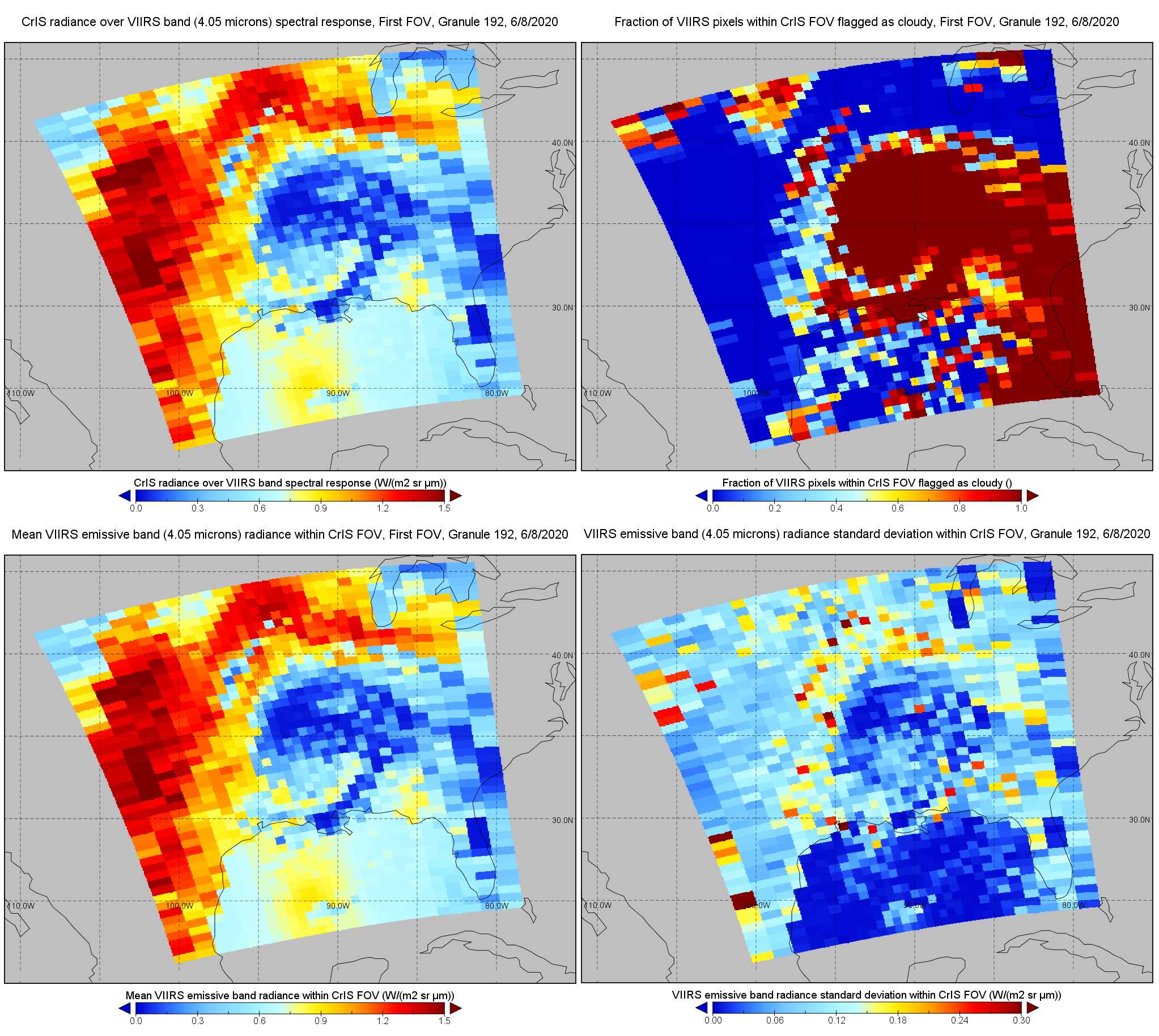
Federal
S-NPP CrIS IMG: Collocated VIIRS level 1 / cloud mask statistical summary V2 (SNDRSNCrISL1BIMG) at GES DISC
National Aeronautics and Space Administration —
The Cross-track Infrared Sounder (CrIS) Level 1B Normal Spectral Resolution (NSR) data files contain radiance measurements along with ancillary spacecraft,... -
Federal
Ocean Surface Current Analyses Real-time (OSCAR) Surface Currents - Near Real Time 0.25 Degree (Version 2.0)
National Aeronautics and Space Administration —
Ocean Surface Current Analyses Real-time (OSCAR) is a global surface current database and NASA funded research project. OSCAR ocean mixed layer velocities are... -
Federal
High Tide Flooding Products from NOAA CO-OPS
National Oceanic and Atmospheric Administration, Department of Commerce —
High tide flooding is the overflow or excess accumulation of water that covers typically dry coastal land and occurs during high tides. As relative sea levels rise,... -
Federal
Dynamics and Chemistry of the Summer Stratosphere Airborne Data Products
National Aeronautics and Space Administration —
DCOTSS-Aircraft-Data features the aircraft data collected during the Dynamics and Chemistry of the Summer Stratosphere sub-orbital campaign. These data products were...

Official websites use .gov
A
.gov website belongs to an official government
organization in the United States.
Secure .gov websites use HTTPS
A
lock (
) or https:// means you’ve safely connected to
the .gov website. Share sensitive information only on official,
secure websites.