
-
Federal
H07800: NOS Hydrographic Survey , 1950-12-31
National Oceanic and Atmospheric Administration, Department of Commerce —
The National Oceanic and Atmospheric Administration (NOAA) has the statutory mandate to collect hydrographic data in support of nautical chart compilation for safe... -
Federal
NOAA/WDS Paleoclimatology - Brown fire data from Cherry Canyon - IMPD USCHR001
National Oceanic and Atmospheric Administration, Department of Commerce —
This archived Paleoclimatology Study is available from the NOAA National Centers for Environmental Information (NCEI), under the World Data Service (WDS) for... -
Federal
NOAA/WDS Paleoclimatology - Brown fire data from O'Neill Pass - IMPD USONP001
National Oceanic and Atmospheric Administration, Department of Commerce —
This archived Paleoclimatology Study is available from the NOAA National Centers for Environmental Information (NCEI), under the World Data Service (WDS) for... -
Federal
First ISCCP Regional Experiment (FIRE) Atlantic Stratocumulus Transition Experiment (ASTEX) University of Washington C-131A Discrete Data
National Aeronautics and Space Administration —
The First ISCCP Regional Experiments have been designed to improve data products and cloud/radiation parameterizations used in general circulation models (GCMs).... -
Federal
NOAA/WDS Paleoclimatology - Skinner fire data from Cedar Lake - IMPD USCDR001
National Oceanic and Atmospheric Administration, Department of Commerce —
This archived Paleoclimatology Study is available from the NOAA National Centers for Environmental Information (NCEI), under the World Data Service (WDS) for... -
Federal
BLM Natl FIAT Northern Great Basin Greater Sage-Grouse Wildfire Invasive Annual Grasses and Conifer Expansion Assessment (NGB) Document
Department of the Interior —
Northern Great Basin - Greater Sage-Grouse Wildfire, Invasive Annual Grasses, and Conifer Expansion Assessment Document, March 2015 The FIAT assessments were... -
Federal
NOAA/WDS Paleoclimatology - Bigio fire data from Klyuchi village, Siberia - IMPD RUKLU001
National Oceanic and Atmospheric Administration, Department of Commerce —
This archived Paleoclimatology Study is available from the NOAA National Centers for Environmental Information (NCEI), under the World Data Service (WDS) for... -
City
Standard of Coverage (SOC) 2022
City of Austin —
Austin Fire's Standard of Coverage (SOC) is goal is to reach 90% of our emergency incidents within 8 mins from call-receipt to on-scene. -
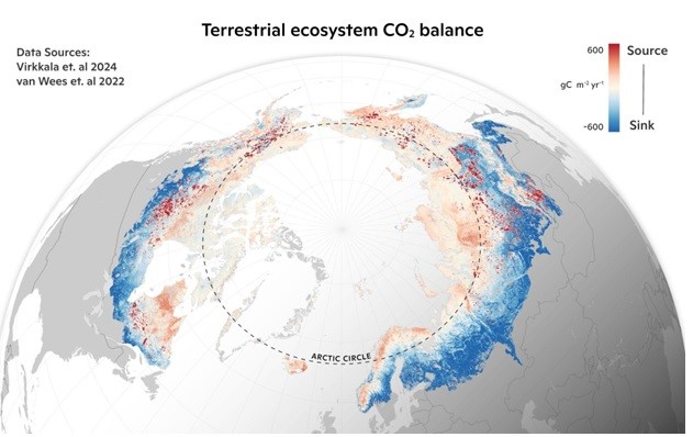
Federal
Machine learning-based Arctic-boreal terrestrial ecosystem CO2 fluxes, 2001-2020
National Aeronautics and Space Administration —
This dataset provides gridded estimates of gross primary productivity (GPP), ecosystem respiration (Reco), and net ecosystem CO2 exchange (NEE) across the circumpolar... -
Federal
Distribution of Estimated Stand Age Across Siberian Larch Forests, 1989-2012
National Aeronautics and Space Administration —
This data set provides mapped estimates of the stand age of young (less than 25 years old) larch forests across Siberia from 1989-2012 at 30-m resolution. The age... -
Federal
MASTER: FireSense, California and Southern US, Spring 2025
National Aeronautics and Space Administration —
This dataset includes Level 1B (L1B) and Level 2 (L2) data products from the MODIS/ASTER Airborne Simulator (MASTER) instrument. The spectral data were collected as... -
Federal
MODIS/Terra+Aqua Direct Broadcast Burned Area Monthly L3 Global 500m SIN Grid V006
National Aeronautics and Space Administration —
The MCD64A1 Version 6 data product was decommissioned on July 31, 2023. Users are encouraged to use the MCD64A1 Version 6.1 data product.The Terra and Aqua combined... -
Federal
LBA-ECO LC-08 Ecosystem Demography Model Estimated C, NPP, and Biomass For Amazonia
National Aeronautics and Space Administration —
This data set provides Ecosystem Demography Model (ED) estimates of potential above-ground net primary production (NPP) (kg C/m2/y), potential average live biomass... -
Federal
VIIRS/NPP Active Fires 6-Min L2 Swath 375m V002
National Aeronautics and Space Administration —
The Visible Infrared Imaging Radiometer Suite (VIIRS) Active Fires (VNP14IMG) Version 2 product is produced in 6-minute temporal satellite increments (swaths) at 375... -
Federal
NOAA/WDS Paleoclimatology - Heinlein fire data from San Francisco Peaks (East) - IMPD USSPE001
National Oceanic and Atmospheric Administration, Department of Commerce —
This archived Paleoclimatology Study is available from the NOAA National Centers for Environmental Information (NCEI), under the World Data Service (WDS) for... -
Federal
NACP Integrated Wildland and Cropland 30-m Fuel Characteristics Map, U.S.A., 2010
National Aeronautics and Space Administration —
The data set provides a 30-m comprehensive fuelbed characteristics map for both the wildland and cropland areas of the conterminous United States (CONUS) for 2010.... -
Federal
Alien Plant Survey Protocol Design
Department of the Interior —
Following a survey effort to describe alien plant invasion of anthropogenically disturbed areas, this project set the stage for inventorying areas of natural... -
Federal
NOAA/WDS Paleoclimatology - Heyerdahl fire data from Cove Mountain - IMPD USCOV001
National Oceanic and Atmospheric Administration, Department of Commerce —
This archived Paleoclimatology Study is available from the NOAA National Centers for Environmental Information (NCEI), under the World Data Service (WDS) for... -
Federal
LBA-ECO TG-10 Fire Emission Factors in Mato Grosso, Para, and Amazonas, Brazil: 2004
National Aeronautics and Space Administration —
This data set provides derived emission factors (EFs), reported in grams of compound emitted per kilogram of dry fuel (g/kg), for PM10 (particulate matter up to 10... -
Federal
NOAA/WDS Paleoclimatology - Heyerdahl fire data from Abajo Mountain - IMPD USABM001
National Oceanic and Atmospheric Administration, Department of Commerce —
This archived Paleoclimatology Study is available from the NOAA National Centers for Environmental Information (NCEI), under the World Data Service (WDS) for...

Official websites use .gov
A
.gov website belongs to an official government
organization in the United States.
Secure .gov websites use HTTPS
A
lock (
) or https:// means you’ve safely connected to
the .gov website. Share sensitive information only on official,
secure websites.