

56 datasets found for "9 Digit ZIP Codes"
-
Federal
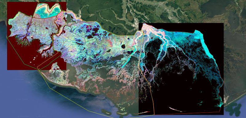
Delta-X: Ecogeomorphic Cell Products across the MRD, LA, USA, 2021
National Aeronautics and Space Administration —
This product delineates the Mississippi River Delta (MRD) landscape into distinct ecogeomorphic cells, which are small contiguous areas of land with similar... -
Federal
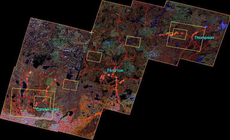
BOREAS Follow-On DSP-01 Landsat TM Land Cover Mosaic of the BOREAS Transect
National Aeronautics and Space Administration —
The objective of this land cover mosaic is to provide a data product that characterises the detailed land cover of a significant portion of the BOREAS Region. Seven... -
Federal
HLS Sentinel-2 Multi-spectral Instrument Surface Reflectance Daily Global 30m v2.0
National Aeronautics and Space Administration —
The Harmonized Landsat Sentinel-2 (HLS) project provides consistent surface reflectance data from the Operational Land Imager (OLI) aboard the joint NASA/USGS Landsat... -
Federal
Imagery data for the Vegetation Mapping Inventory Project of Lava Beds National Monument
Department of the Interior —
This reference contains the imagery data used in the completion of the baseline vegetation inventory project for the NPS park unit. Orthophotos, raw imagery, and... -
Federal
Global Food Security-support Analysis Data (GFSAD) Cropland Extent 2015 Africa 30 m V001
National Aeronautics and Space Administration —
The NASA Making Earth System Data Records for Use in Research Environments (MEaSUREs) Global Food Security-support Analysis Data (GFSAD) data product provides... -
Federal
BDSNP Module for Improved Soil NO Emission Estimates for CMAQ Model, Conterminous USA
National Aeronautics and Space Administration —
This model product provides: (1) the source code for the updated Berkeley-Dalhousie Soil Nitric Oxide (NO) Parameterization module (BDSNP, Version 1.0) as implemented... -
Federal
Global Food Security-support Analysis Data (GFSAD) Cropland Extent 2015 Southeast and Northeast Asia product 30 m V001
National Aeronautics and Space Administration —
The NASA Making Earth System Data Records for Use in Research Environments (MEaSUREs) Global Food Security-support Analysis Data (GFSAD) data product provides... -
Federal
Automobile Campgrounds in the North Cascades National Park Service Complex, nautocampl1.shp
Department of the Interior —
ArcGIS shapefile line features depicting drive-in sites and access roads within automobile campgrounds in the Ross Lake National Recreation Area of the North Cascades... -
Federal
Skagit Rivermiles within the North Cascades National Park Service Complex, nskagmilep1.shp
Department of the Interior —
The points in this ArcGIS shapefile mark river miles for the Skagit River, from river mile 50 (roughly 30 miles west of Park boundary) to river mile 127 (northern... -
Federal
Automobile Campgrounds (walk-ins and other site features) in the North Cascades National Park Service Complex, nautocampp1.shp
Department of the Interior —
ArcGIS shapefile depicting point locations of automobile campgrounds in the Ross Lake National Recreation Area of the North Cascades National Park Service Complex.... -
Federal
Campgrounds (frontcountry and backcountry) in the North Cascades National Park Service Complex, Washington, ncampsp1.shp
Department of the Interior —
ArcGIS shapefile point features depicting backcountry camps and frontcountry campgrounds within the North Cascades National Park Service Complex, Washington.... -
Federal
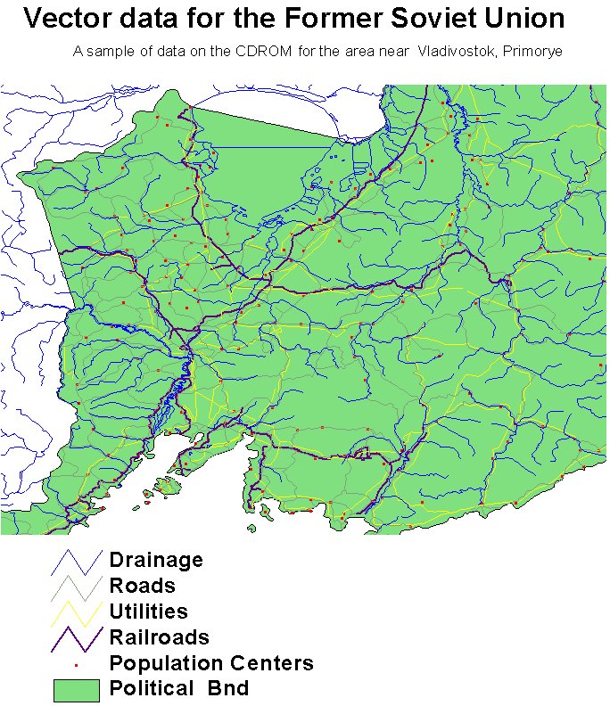
RLC Selected Infrastructure Data for the Former Soviet Union, 1993
National Aeronautics and Space Administration —
This data set consists of roads, drainage, railroads, utilities, and population center information in readily usable vector format for the land area of the Former... -
Federal
RLC Forest Stand Carbon Map of Russia
National Aeronautics and Space Administration —
This dataset is a 1:15 million scale map of forest stand carbon for the land area of Russia (Stone et al., 2000). The objective was to create a first approximation of... -
Federal
Global Food Security-support Analysis Data (GFSAD) Cropland Extent 2010 North America product 30 m V001
National Aeronautics and Space Administration —
The NASA Making Earth System Data Records for Use in Research Environments (MEaSUREs) Global Food Security-support Analysis Data (GFSAD) data product provides... -
Federal
ABoVE/ASCENDS: Atmospheric Backscattering Coefficient Profiles from CO2 Sounder, 2017
National Aeronautics and Space Administration —
This dataset provides atmospheric backscattering coefficient profiles collected during Active Sensing of CO2 Emissions over Nights, Days, and Seasons (ASCENDS)... -
Federal
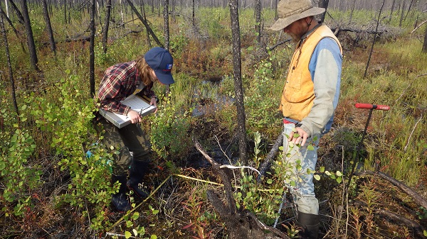
ABoVE: Post-Fire and Unburned Vegetation Community and Field Data, NWT, Canada, 2017
National Aeronautics and Space Administration —
This dataset provides vegetation community characteristics, soil moisture, and biophysical data collected in 2017 from 11 study sites in the ABoVE Study area. The 11...
56 datasets found for "9 Digit ZIP Codes"