
-
Federal
Global Fire Emissions Indicators, Country-Level Tabular Data: 1997-2015
National Aeronautics and Space Administration —
The Global Fire Emissions Indicators, Country-Level Tabular Data: 1997-2015 contains country tabulations from 1997 to 2015 for the total area burned (hectares) and... -
Federal
ASTER Level 1 Precision Terrain Corrected Registered At-Sensor Radiance V031
National Aeronautics and Space Administration —
The Terra Advanced Spaceborne Thermal Emission and Reflection Radiometer (ASTER) Level 1 Precision Terrain Corrected Registered At-Sensor Radiance (AST_L1T) Version... -
Federal
SWOT Level 2 KaRIn Low Rate Sea Surface Height Data Product - Basic, Version 2.0
National Aeronautics and Space Administration —
The SWOT Level 2 KaRIn Low Rate Sea Surface Height Basic Data Product from the Surface Water Ocean Topography (SWOT) mission provides global sea surface height and... -
Federal
U.S. Climate Risk Projections by County, 2040-2049
National Aeronautics and Space Administration —
The U.S. Climate Risk Projections by County, 2040-2049 data set contains a projection for 2040-2049 risk for the entire contiguous U.S. at the county level with a... -
Federal
H12132: NOS Hydrographic Survey , Thunder Bay, Michigan, 2010-11-04
National Oceanic and Atmospheric Administration, Department of Commerce —
The National Oceanic and Atmospheric Administration (NOAA) has the statutory mandate to collect hydrographic data in support of nautical chart compilation for safe... -
Federal
MODIS/Terra+Aqua Land Cover Type Yearly L3 Global 500m SIN Grid V006
National Aeronautics and Space Administration —
The MCD12Q1 Version 6 data product was decommissioned on July 31, 2023. Users are encouraged to use the MCD12Q1 Version 6.1 data product.The Terra and Aqua combined... -
Federal
Daily and Annual PM2.5, O3, and NO2 Concentrations at ZIP Codes for the Contiguous U.S., 2000-2016, v1.0
National Aeronautics and Space Administration —
The Daily and Annual PM2.5, O3, and NO2 Concentrations at ZIP Codes for the Contiguous U.S., 2000-2016, v1.0 data set contains daily and annual concentration... -
Federal
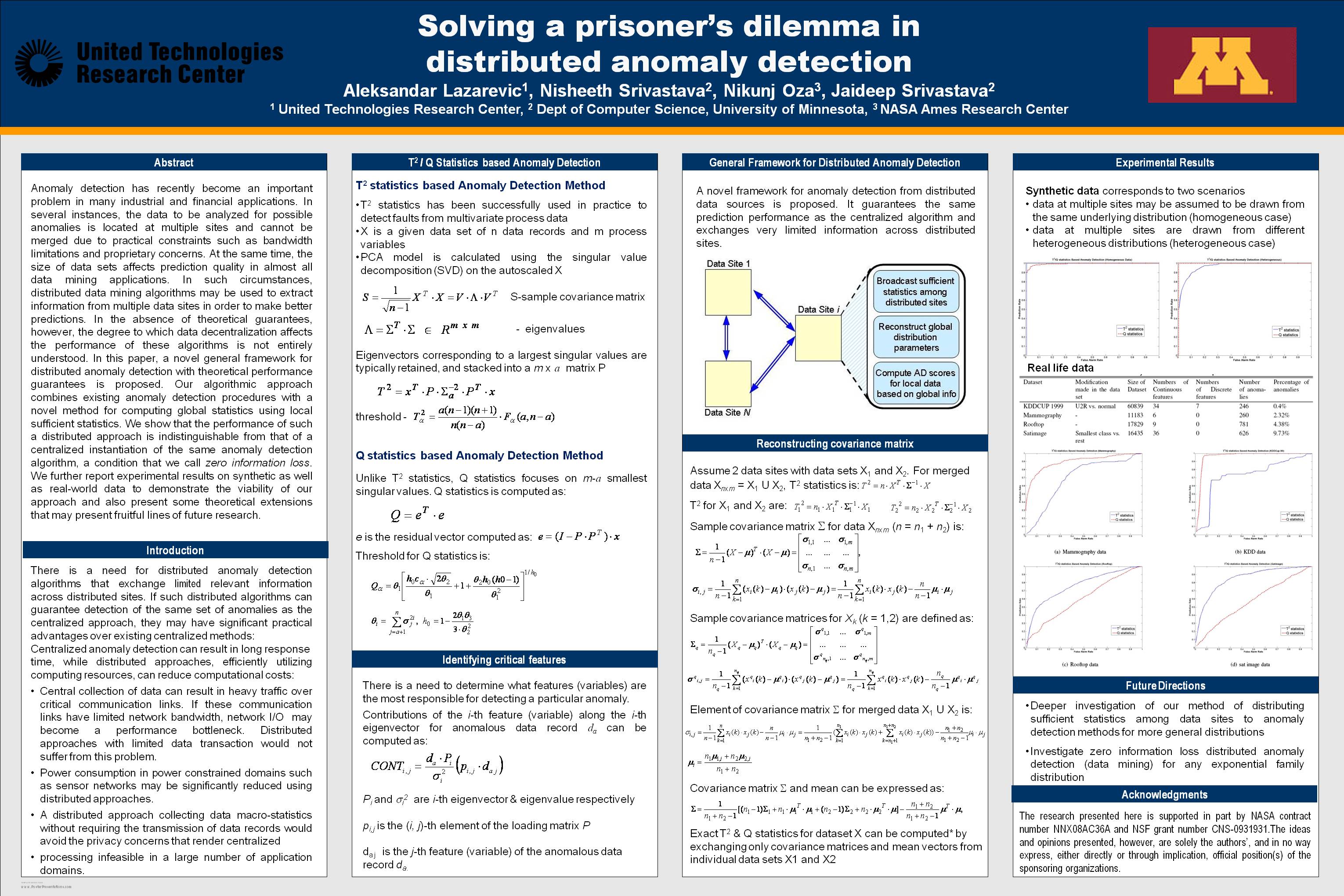
Solving a prisoner's dilemma in distributed anomaly detection
National Aeronautics and Space Administration —
Anomaly detection has recently become an important problem in many industrial and financial applications. In several instances, the data to be analyzed for possible... -
Federal
Northern and Mid-Latitude Soil Database, Version 1, R1
National Aeronautics and Space Administration —
The U.S. Department of Agriculture, Agriculture and Agri-Food Canada, the Russian Academy of Agricultural Sciences, the University of Copenhagen Institute of... -
Federal
TROPICS05 L1B Orbital Geolocated Native-Resolution Brightness Temperatures V0.2
National Aeronautics and Space Administration —
The "Time-Resolved Observations of Precipitation structure and storm Intensity with a Constellation of Smallsats" (TROPICS) mission has a goal of providing nearly... -
Federal
H12047: NOS Hydrographic Survey , Honolulu Harbor, Hawaii, 2009-05-03
National Oceanic and Atmospheric Administration, Department of Commerce —
The National Oceanic and Atmospheric Administration (NOAA) has the statutory mandate to collect hydrographic data in support of nautical chart compilation for safe... -
Federal
Annual Mean PM2.5 Components (EC, NH4, NO3, OC, SO4) 50m Urban and 1km Non-Urban Area Grids for Contiguous U.S., 2000-2019 v1
National Aeronautics and Space Administration —
The Annual Mean PM2.5 Components (EC, NH4, NO3, OC, SO4) 50m Urban and 1km Non-Urban Area Grids for Contiguous U.S., 2000-2019, v1 data set contains annual... -
Federal
MetOp-C ASCAT Level 2 Ocean Surface Wind Vectors Optimized for Coastal Ocean
National Aeronautics and Space Administration —
This dataset contains operational near-real-time Level 2 coastal ocean surface wind vector retrievals from the Advanced Scatterometer (ASCAT) on MetOp-C at 12.5 km... -
Federal
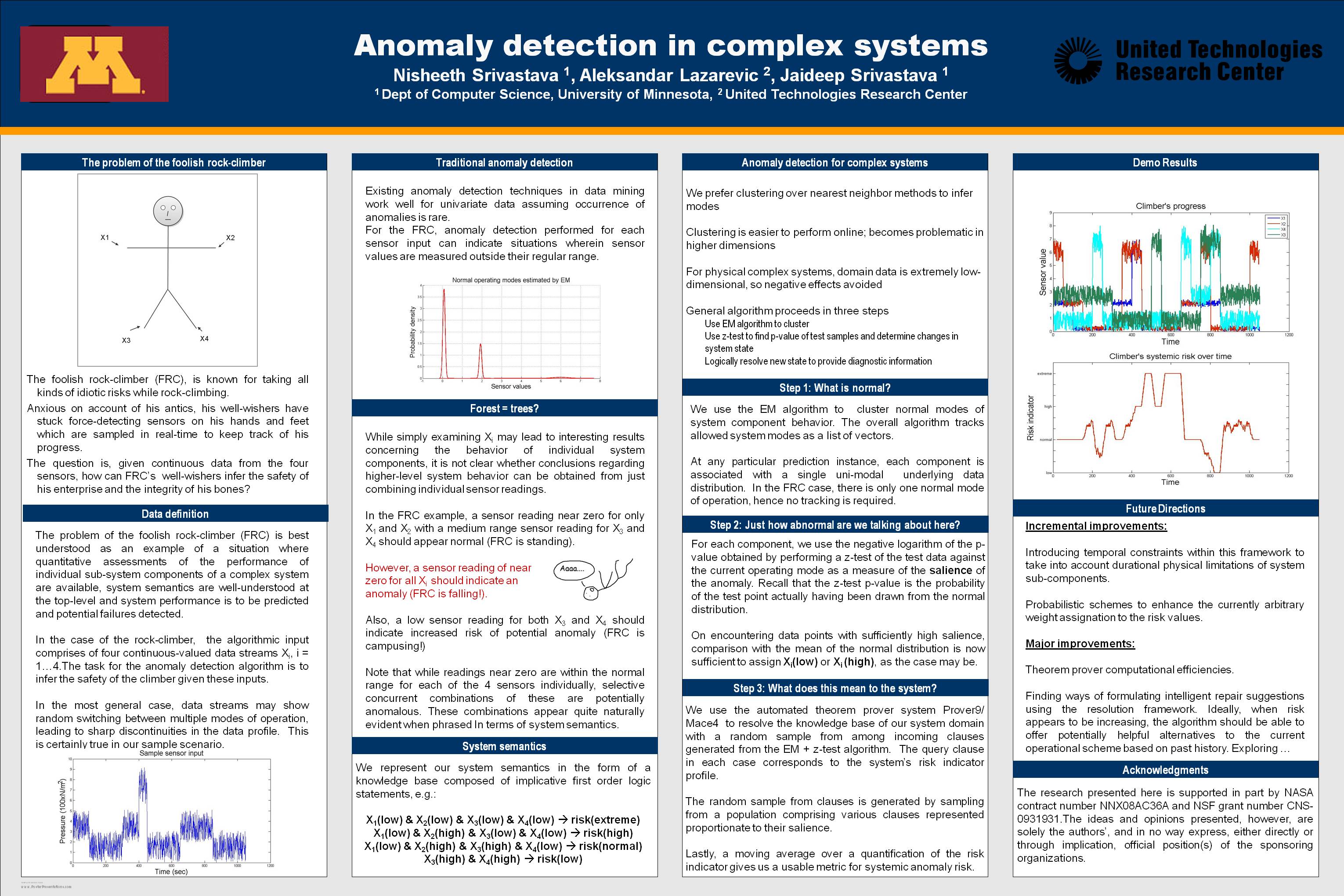
Anomaly Detection for Complex Systems
National Aeronautics and Space Administration —
In performance maintenance in large, complex systems, sensor information from sub-components tends to be readily available, and can be used to make predictions about... -
Federal
ASTER L2 Surface Reflectance SWIR and ASTER L2 Surface Reflectance VNIR V003
National Aeronautics and Space Administration —
The Terra Advanced Spaceborne Thermal Emission and Reflection Radiometer (ASTER) Surface Reflectance VNIR and SWIR (AST_07) data product contains measures of the... -
Federal
SWOT Level 2 KaRIn Low Rate Sea Surface Height Data Product - WindWave, Version 2.0
National Aeronautics and Space Administration —
The SWOT Level 2 KaRIn Low Rate Sea Surface Height Windwave Data Product from the Surface Water Ocean Topography (SWOT) mission provides global sea surface height and... -
Federal
Archive of Census Related Products (ACRP): 1990 Census Block Statistics
National Aeronautics and Space Administration —
The 1990 Census Block Statistics portion of the Archive of Census Related Products (ACRP) contains population and housing data from the U.S. Census Bureau's 1990... -
Federal
SWOT Level 2 Lake Single-Pass Vector Obs Data Product, Version 2.0
National Aeronautics and Space Administration —
The SWOT Level 2 Lake Single-Pass Vector Obs Data Product from the Surface Water Ocean Topography (SWOT) mission provides water surface elevation, area, storage... -
Federal
Data and code from: AI-based image profiling and detection for the beetle byte quintet using Vision Transformer (ViT) in advanced stored product infestation monitoring
Department of Agriculture —
Managing beetles that infest stored products is crucial for reducing losses in harvest supply chains and improving food security and safety. Successful pest... -
Federal
Archive of Census Related Products (ACRP): 1990 Standard Extract Files
National Aeronautics and Space Administration —
The 1990 Standard Extract Files portion of the Archive of Census Related Products (ACRP) contains population and housing data derived from the U.S. Census Bureau's...

Official websites use .gov
A
.gov website belongs to an official government
organization in the United States.
Secure .gov websites use HTTPS
A
lock (
) or https:// means you’ve safely connected to
the .gov website. Share sensitive information only on official,
secure websites.
.jpg)