
-
Federal
MASTER: California Fire-Burn Area Emergency Response, California, April 2008
National Aeronautics and Space Administration —
This dataset includes Level 1B (L1B) data products from the MODIS/ASTER Airborne Simulator (MASTER) instrument. The spectral data were collected as part of the... -
Federal
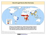
Global Drought Mortality Risks and Distribution
National Aeronautics and Space Administration —
The Global Drought Mortality Risks and Distribution is a 2.5 minute grid of global drought mortality risks. Gridded Population of the World, Version 3 (GPWv3) data... -
Federal
NOAA GOES-R Series Advanced Baseline Imager (ABI) Level 2 Fire/Hot Spot Characterization (FDC)
National Oceanic and Atmospheric Administration, Department of Commerce —
The GOES-R Advanced Baseline Imager (ABI) Fire (HSC) product contains four images, one in the form of a fire mask, and the other three with pixel values identifying... -
Federal
BLM OR Areas of Critical Environmental Concern Historic Polygon Hub
Department of the Interior —
ACEC_HIST_POLY: This polygon feature class contains BLM Historical Areas of Critical Environmental Concern (ACECs) polygons. These define areas within the public... -
Federal
Annual Global High-Resolution Extreme Heat Estimates (GEHE), 1983-2016
National Aeronautics and Space Administration —
The Annual Global High-Resolution Extreme Heat Estimates (GEHE), 1983-2016 data set provides global 0.05 degrees (~5 km) gridded annual counts of the number of days... -
Federal
Global Landslide Nowcast from LHASA L4 1 day 1 km x 1 km version 2.0.0 (Global_Landslide_Nowcast) at GES DISC
National Aeronautics and Space Administration —
The Global Landslide Nowcast addresses the need for real-time situational awareness of landslide hazard. The Landslide Hazard Assessment for Situational Awareness... -
Federal
LBA-ECO LC-08 Passive Ground-based Fire Data, Para and Mato Grosso Brazil: 2001-2002
National Aeronautics and Space Administration —
This data set reports observations of fires in the vicinity of Maraba, Para, Brazil, from November 3-5th, 2001, and in Mato Grosso, Brazil, between Cuiaba and Alta... -
Federal
Archival and Discovery of December 23, 1854 Tsunami Event on Marigrams
National Oceanic and Atmospheric Administration, Department of Commerce —
NOAA National Centers for Environmental Information have more than 3,000 tsunami marigram (tide gauge) records in both image and paper format. The majority of these... -
Federal
Archival and Discovery of November 27, 1945 Tsunami Event on Marigrams
National Oceanic and Atmospheric Administration, Department of Commerce —
These water level data were digitized from a scanned marigram image associated with the tsunami event of 1945-11-27 at a tide gauge located at Karachi, Pakistan, and... -
Federal
BLM Natl Areas of Critical Environmental Concern
Department of the Interior —
This polygon feature class contains BLM Designated Areas of Critical Environmental Concern (ACECs) polygons. These define areas within the public lands where special... -
Federal
Global Flood Proportional Economic Loss Risk Deciles
National Aeronautics and Space Administration —
The Global Flood Proportional Economic Loss Risk Deciles is a 2.5 minute grid of flood hazard economic loss as proportions of Gross Domestic Product (GDP) per... -
Federal
ABoVE: Active Layer Soil Characteristics at Selected Sites Across Alaska
National Aeronautics and Space Administration —
This dataset provides soil active layer characteristics from nine locations across Alaska. Soil samples were collected in 2016 except for one site which was sampled... -
Federal
Archival and Discovery of May 16, 1968 Tsunami Event on Marigrams
National Oceanic and Atmospheric Administration, Department of Commerce —
NOAA National Centers for Environmental Information have more than 3,000 tsunami marigram (tide gauge) records in both image and paper format. The majority of these... -
Federal
Global Landslide Mortality Risks and Distribution
National Aeronautics and Space Administration —
The Global Landslide Mortality Risks and Distribution is a 2.5 minute grid of global landslide mortality risks. Gridded Population of the World, Version 3 (GPWv3)... -
Federal
Global Earthquake Hazard Frequency and Distribution
National Aeronautics and Space Administration —
The Global Earthquake Hazard Frequency and Distribution is a 2.5 minute grid utilizing Advanced National Seismic System (ANSS) Earthquake Catalog data of actual... -
Federal
NEOWAVE Regional Tsunami Model: Hawaii: Molokai: Kaunakakai
National Oceanic and Atmospheric Administration, Department of Commerce —
Non-hydrostatic Evolution of Ocean WAVEs (NEOWAVE) regional tsunami model for Kaunakakai Harbor on the south coast of the island of Molokai in the state of Hawaii,... -
Federal
NOAA GOES-R Series Advanced Baseline Imager (ABI) Level 2 Volcanic Ash: Detection and Height (VAA)
National Oceanic and Atmospheric Administration, Department of Commerce —
The Volcanic Ash: Detection and Height product contains two images with pixel values identifying volcanic ash cloud height and volcanic ash mass loading. The ash... -
Federal
Water Level Data from National Tsunami Warning Center Tide Gauges in Alaska and California
National Oceanic and Atmospheric Administration, Department of Commerce —
The National Tsunami Warning Center (NTWC) of the National Weather Service (NWS), an organizational element of NOAA, operates and maintains a network of approximately... -
Federal
MASTER: FireSense, California and Southern US, Spring 2025
National Aeronautics and Space Administration —
This dataset includes Level 1B (L1B) and Level 2 (L2) data products from the MODIS/ASTER Airborne Simulator (MASTER) instrument. The spectral data were collected as... -
Federal
NEOWAVE Regional Tsunami Model: South Hawaii PMT: Hawaii: Hawaii Island: Halape
National Oceanic and Atmospheric Administration, Department of Commerce —
Non-hydrostatic Evolution of Ocean WAVEs (NEOWAVE) regional tsunami model for the southeast coast of Hawaii Island in the State of Hawaii, including Halape, Hawaii...

Official websites use .gov
A
.gov website belongs to an official government
organization in the United States.
Secure .gov websites use HTTPS
A
lock (
) or https:// means you’ve safely connected to
the .gov website. Share sensitive information only on official,
secure websites.