
-
Federal
SAFARI 2000 Kalahari Transect CO2, Water Vapor, and Heat Flux, Wet Season 2000
National Aeronautics and Space Administration —
Short-term measurements of carbon dioxide, water, and energy fluxes were collected at four locations along a mean annual precipitation gradient in southern Africa... -
Federal
SAFARI 2000 Woody Vegetation Characteristics of Kalahari and Skukuza Sites
National Aeronautics and Space Administration —
This data set contains species composition, basal area, height, and crown cover of all woody plants at six sites along the Kalahari Transect visited in February-March... -
Federal
SAFARI 2000 MODIS Water and Heat Fluxes, Maun, Botswana, Dry Season 2001
National Aeronautics and Space Administration —
A physically-based model, Energy: Surface Towards Atmosphere (ESTA), was used to model and map the energy and water balances of a heterogeneous land surface in a... -
Federal
SAFARI 2000 Modeled Fuel Load in Southern Africa, 1999-2000
National Aeronautics and Space Administration —
This data set contains global, spatially explicit (1 km2 grid cells) and temporally explicit (semi-monthly) modeled output of fuel loads over southern Africa. The... -
Federal
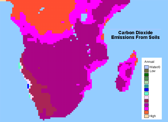
SAFARI 2000 Monthly and Annual CO2 Emissions from Soil, 0.5 Degree Grid
National Aeronautics and Space Administration —
The data set provides estimated monthly and annual soil CO2 emissions for southern Africa (the SAFARI 2000 project region). The calculated emissions are from the... -
Federal
Resilience of Coastal Wetlands to Sea Level Rise, CONUS, 1996-2100
National Aeronautics and Space Administration —
This dataset provides information about the resilience of tidal wetlands to sea-level rise under three scenarios of global change. With rising seas, regularly... -
Federal
SAFARI 2000 NBI Vegetation Map of the Savannas of Southern Africa
National Aeronautics and Space Administration —
The National Botanical Institute (NBI) has mapped woody plant species distribution to provide estimates of individual species contribution to peak leaf area index for... -
Federal
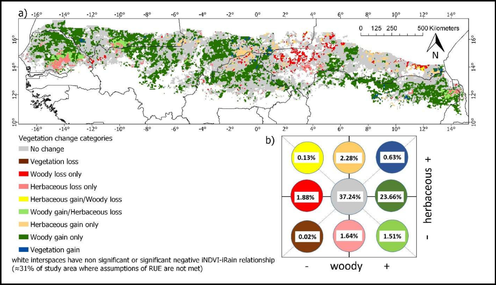
Woody and Herbaceous Vegetation Change across the Savannas of West Africa, 1982-2013
National Aeronautics and Space Administration —
The WAVeTrends dataset is a 0.05 degree (5.55 km) vegetation change product, spanning the West African Sudano-Sahel region. It provides pixel-wise information on... -
Federal
Surface Meteorology Data: NCDC (FIFE)
National Aeronautics and Space Administration —
The NOAA Regional Surface Data - 1989 (NCDC) Data Set contains hourly surface meteorological data for the FIFE area. Though the measurements presented in this data... -
Federal
SNF Forest Phenology/Leaf Expansion Data
National Aeronautics and Space Administration —
The purpose of the SNF study was to improve understanding of the relationship between remotely sensed observations and important biophysical parameters in the boreal... -
Federal
Aircraft Flux-Filtered: NRCC (FIFE)
National Aeronautics and Space Administration —
The purpose of this study was to develop alternatives to ground-based measurements in order to obtain information required to predict the effects of soil and land use... -
Federal
Aircraft Flux-Detrended: NRCC (FIFE)
National Aeronautics and Space Administration —
The purpose of this study was to develop alternatives to ground-based measurements in order to obtain information required to predict the effects of soil and land use... -
Federal
Global Leaf Area Index from Field Measurements, 1932-2000
National Aeronautics and Space Administration —
Approximately 1000 published estimates of leaf area index (LAI) from nearly 400 unique field sites, covering the period 1932-2000, have been compiled into a single... -
Federal
Ecosystem Demography Model: Scaling Vegetation Dynamics Across South America
National Aeronautics and Space Administration —
This model product contains the source code for the Ecosystem Demography Model (ED version 1.0) as well as model input and output data for a portion of South America... -
Federal
Global Peatland Carbon Balance and Land Use Change CO2 Emissions Through the Holocene
National Aeronautics and Space Administration —
This data set provides a time series of global peatland carbon balance and carbon dioxide emissions from land use change throughout the Holocene (the past 11,000... -
Federal
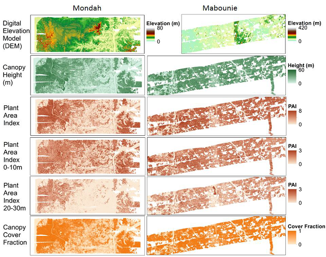
AfriSAR: Gridded Forest Biomass and Canopy Metrics Derived from LVIS, Gabon, 2016
National Aeronautics and Space Administration —
This dataset contains gridded forest characterization products derived from full-waveform lidar data acquired by NASA's airborne Land, Vegetation, and Ice Sensor...

Official websites use .gov
A
.gov website belongs to an official government
organization in the United States.
Secure .gov websites use HTTPS
A
lock (
) or https:// means you’ve safely connected to
the .gov website. Share sensitive information only on official,
secure websites.