
-
Federal
LBA-ECO ND-01 Landsat 28.5-m Land Cover Time Series, Rondonia, Brazil: 1984-2010
National Aeronautics and Space Administration —
This data set provides a 27-year land cover time series of 28.5-m resolution products derived from Landsat images for 80% of Rondonia, Brazil, for the period 1984 to... -
Federal
LBA-ECO LC-07 Aquatic Marcophyte Biomass, Monte Alegre Lake, Para, Brazil: 2003-2004
National Aeronautics and Space Administration —
This data set reports measurements of aquatic macrophyte biomass, phenology, leaf characteristics, and length and diameter of stems of both submerged and unsubmerged... -
Federal
LBA-ECO CD-06 Flux of CO2 from Amazon Mainstem Rivers, Tributaries, and Floodplains
National Aeronautics and Space Administration —
This data set provides estimates of monthly carbon dioxide (CO2) flux from the Amazon mainstem rivers, tributary stream networks, and their associated varzeas... -
Federal
LBA-ECO LC-14 Biophysical Measurements, Rainfall Exclusion, Tapajos National Forest
National Aeronautics and Space Administration —
This data set reports forest biophysical measurements from a rainfall exclusion experiment conducted at the km 67 Seca Floresta site, Tapajos National Forest, Brazil... -
Federal
LBA-ECO CD-08 Tropical Forest Ecosystem Respiration, Manaus, Brazil
National Aeronautics and Space Administration —
Understanding how tropical forest carbon balance will respond to global change requires knowledge of individual heterotrophic and autotrophic respiratory sources,... -
Federal
LBA-ECO CD-08 Radiocarbon Dating of Tree Ages in Amazonas, Acre, and Para in Brazil
National Aeronautics and Space Administration —
This data set reports the ages and growth rates of trees determined by radiocarbon dating (14C) in three Amazonia forests. Tree samples were collected from permanent... -
Federal
ISLSCP II Carbon Dioxide Emissions from Fossil Fuels, Cement, and Gas Flaring
National Aeronautics and Space Administration —
This data set contains decadal (1950, 1960, 1970, 1980, 1990 and 1995) estimates of gridded fossil-fuel emissions, expressed in 1,000 metric tons C per year per one... -
Federal
In-situ Air Temperature and Relative Humidity in Greenbelt, MD, 2013-2015
National Aeronautics and Space Administration —
This data set describes the temperature and relative humidity at 12 locations around Goddard Space Flight Center in Greenbelt MD at 15 minute intervals between... -
Federal
LBA-ECO CD-10 CO2 and H2O Eddy Flux Data at km 67 Tower Site, Tapajos National Forest
National Aeronautics and Space Administration —
This data set reports eddy flux measurements of CO2 and H2O exchange and associated meteorological measurements at the Para Western (Santarem) - km 67, Primary Forest... -
Federal
LBA-ECO LC-01 Northern Ecuadorian Amazon Household Surveys, Summary Results: 1999
National Aeronautics and Space Administration —
This data set reports summary statistics from socioeconomic and demographic surveys administered to the male and female heads of household on 767 farm plots. The... -
Federal
Integrated Biosphere Simulator Model (IBIS), Version 2.5
National Aeronautics and Space Administration —
The Integrated Biosphere Simulator (or IBIS) is designed to be a comprehensive model of the terrestrial biosphere; the model represents a wide range of processes,... -
Federal
MASTER: Wildfire and farmland mapping, California, July, 2004
National Aeronautics and Space Administration —
This dataset includes Level 1B (L1B) and Level 2 (L2) data products from the MODIS/ASTER Airborne Simulator (MASTER) instrument. The spectral data were collected... -
Federal
LBA-ECO TG-05 NPP, Carbon Pool, Soil Characteristics, Soil Gas Flux Maps of Brazil
National Aeronautics and Space Administration —
This data set provides maps produced from model output data from the National Aeronautics and Space Administration-Carnegie Ames Stanford Approach (NASA-CASA) model... -
Federal
LBA-ECO TG-07 Soil Trace Gas Fluxes km 67 Seca-Floresta Site, Tapajos National Forest
National Aeronautics and Space Administration —
Trace gas fluxes of carbon dioxide, methane, nitrous oxide, and nitric oxide (CO2, CH4, N2O, and NO) from surface soil were measured manually in an undisturbed forest... -
Federal
LUH1: Harmonized Global Land Use for Years 1500-2100, V1
National Aeronautics and Space Administration —
These data represent fractional land use and land cover patterns annually for the years 1500 - 2100 for the globe at 0.5-degree (~50-km) spatial resolution. Land use... -
Federal
LBA-ECO ND-02 Soil Trace Gas Fluxes in Eastern Amazonia, Para, Brazil: 1999-2003
National Aeronautics and Space Administration —
Changes in land-use and climate are likely to alter moisture and substrate availability in tropical forest soils, but quantitative assessment of the role of resource... -
Federal
VEMAP 1: U.S. Potential Natural Vegetation
National Aeronautics and Space Administration —
The Vegetation/Ecosystem Modeling and Analysis Project (VEMAP) is an ongoing multiinstitutional, international effort addressing the response of biogeography and... -
Federal
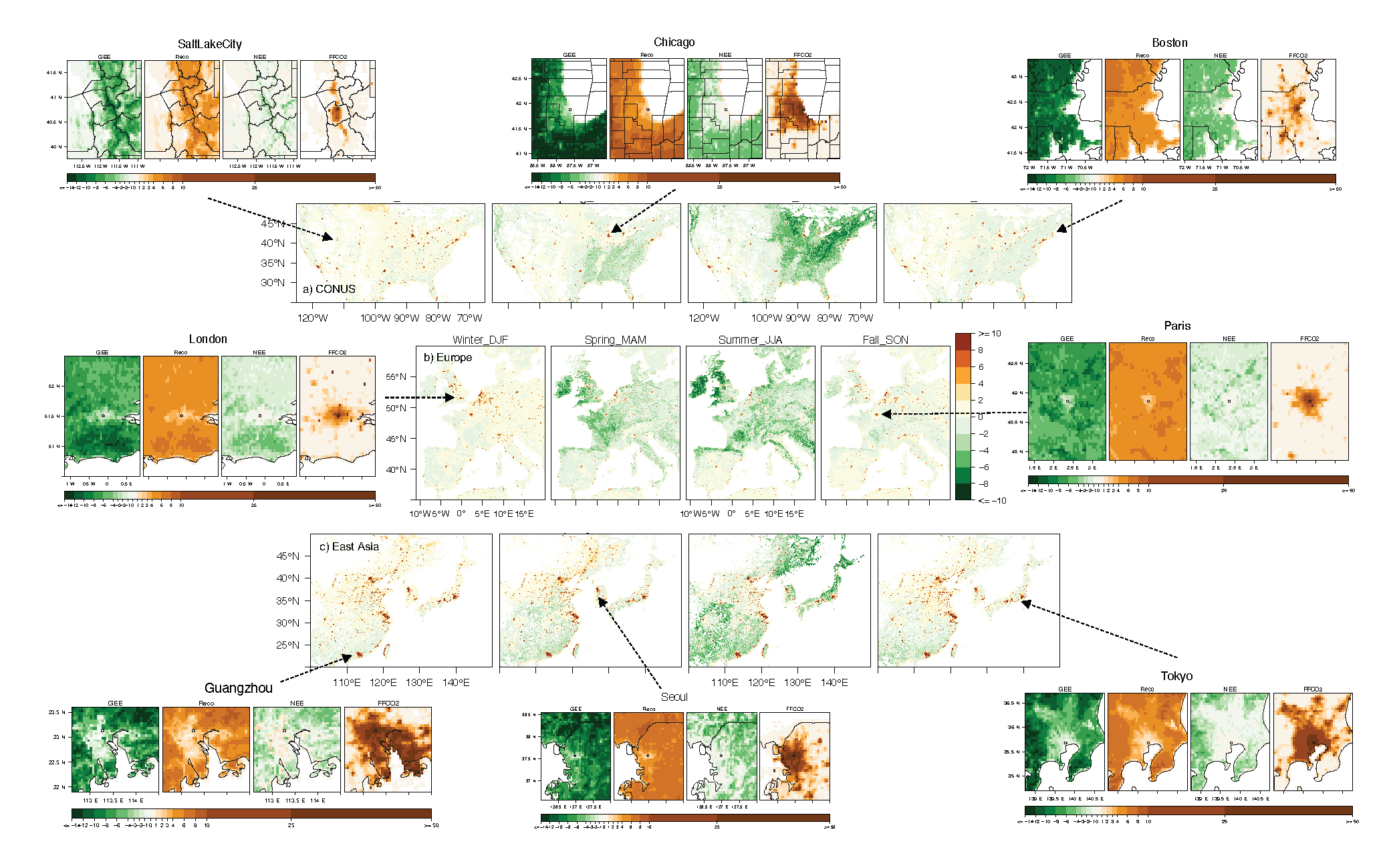
Urban Biogenic CO2 fluxes: GPP, Reco and NEE Estimates from SMUrF, 2010-2019
National Aeronautics and Space Administration —
This dataset contains estimates of biogenic CO2 flux components at 0.05 degree resolution from the Solar-Induced Fluorescence (SIF) for Modeling Urban biogenic Fluxes... -
Federal
SAFARI 2000 TOVS Surface and Atmospheric Parameters, 1-Deg, 1999-2001
National Aeronautics and Space Administration —
NOAA's TIROS (Television Infrared Observation Satellite) Operational Vertical Sounder (TOVS) is a suite of three sensors: the Microwave Sounding Unit (MSU), the High...

Official websites use .gov
A
.gov website belongs to an official government
organization in the United States.
Secure .gov websites use HTTPS
A
lock (
) or https:// means you’ve safely connected to
the .gov website. Share sensitive information only on official,
secure websites.