
-
Federal
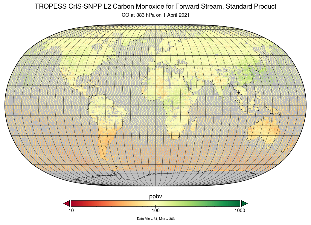
TROPESS CrIS-SNPP L2 Carbon Monoxide for Forward Stream, Standard Product V1 (TRPSDL2COCRSFS) at GES DISC
National Aeronautics and Space Administration —
The TROPESS CrIS-SNPP L2 Carbon Monoxide for Forward Stream, Standard Product contains the vertical distribution of the retrieved atmospheric state of carbon monoxide... -
Federal
THIR/Nimbus-4 Level 1 Meteorological Radiation Data at 11.5 microns V001 (THIRN4L1CH115) at GES DISC
National Aeronautics and Space Administration —
THIRN4L1CH115 is the Nimbus-4 Temperature-Humidity Infrared Radiometer (THIR) Level 1 Meteorological Radiation Data at 11.5 microns product and contains radiances... -
Federal
TROPESS CrIS-SNPP L2 for Sao Paulo Megacity, Standard Product V1 (TRPSDL2ALLCRSMGSAO) at GES DISC
National Aeronautics and Space Administration —
The TROPESS CrIS-SNPP L2 for Sao Paulo Megacity, Standard Product contains the vertical distribution of seven retrieved atmospheric gases (CH4, CO, H2O, HDO, NH3, O3... -
Federal
TROPESS Chemical Reanalysis Surface PAN 2-Hourly 2-dimensional Product V1 (TRPSCRPAN2H2D) at GES DISC
National Aeronautics and Space Administration —
The TROPESS Chemical Reanalysis PAN 2-Hourly 2-dimensional Product contains surface concentrations of peryoxyacetyl nitrate. The data are part of the Tropospheric... -
Federal
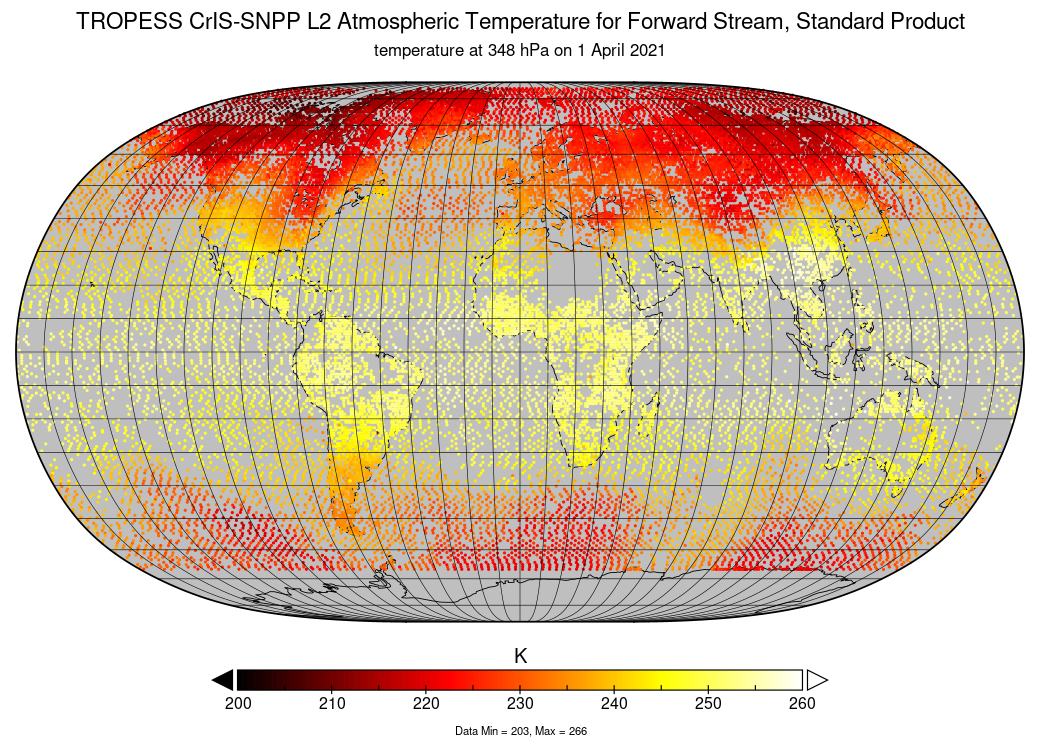
TROPESS CrIS-SNPP L2 Atmospheric Temperature for Forward Stream, Standard Product V1 (TRPSDL2TATMCRSFS) at GES DISC
National Aeronautics and Space Administration —
The TROPESS CrIS-SNPP L2 Atmospheric Temperature for Forward Stream, Standard Product contains the vertical distribution of the retrieved atmospheric state of... -
Federal
GLDAS Noah Land Surface Model L4 3 hourly 1.0 x 1.0 degree V2.1 (GLDAS_NOAH10_3H) at GES DISC
National Aeronautics and Space Administration —
NASA Global Land Data Assimilation System Version 2 (GLDAS-2) has three components: GLDAS-2.0, GLDAS-2.1, and GLDAS-2.2. GLDAS-2.0 is forced entirely with the... -
Federal
TROPESS Chemical Reanalysis O3 Spread 6-Hourly 3-dimensional Product V1 (TRPSCRO3S6H3D) at GES DISC
National Aeronautics and Space Administration —
The TROPESS Chemical Reanalysis O3 Spread 6-Hourly 3-dimensional Product contains the ozone ensemble spread, a measure of data assimilation analysis uncertainty. The... -
Federal
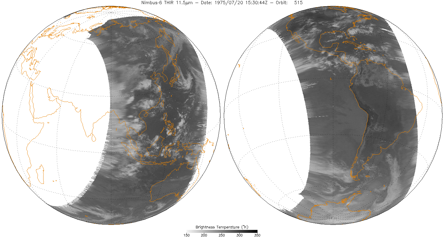
THIR/Nimbus-6 Level 1 Meteorological Radiation Data at 11.5 microns V001 (THIRN6L1CH115) at GES DISC
National Aeronautics and Space Administration —
THIRN6L1CH115 is the Nimbus-6 Temperature-Humidity Infrared Radiometer (THIR) Level 1 Meteorological Radiation Data at 11.5 microns product and contains radiances... -
Federal
TROPESS Chemical Reanalysis Lightning NOx emissions Monthly 2-dimensional Product V1 (TRPSCRENOXLM2D) at GES DISC
National Aeronautics and Space Administration —
The TROPESS Chemical Reanalysis Lightning NOx emissions Monthly 2-dimensional Product contains nitrogen oxides (NO and NO2) emissions from lightning strikes. The data... -
Federal
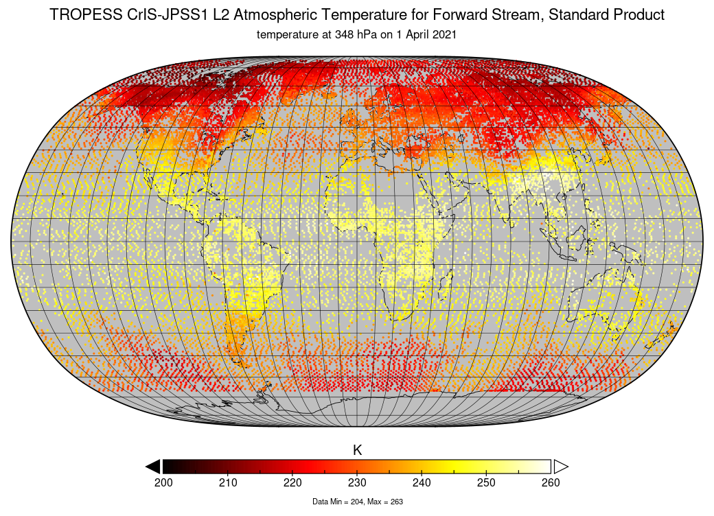
TROPESS CrIS-JPSS1 L2 Atmospheric Temperature for Forward Stream, Standard Product V1 (TRPSDL2TATMCRS1FS) at GES DISC
National Aeronautics and Space Administration —
The TROPESS CrIS-JPSS1 L2 Atmospheric Temperature for Forward Stream, Standard Product contains the vertical distribution of the retrieved atmospheric state of... -
Federal
GLDAS Catchment Land Surface Model L4 3 hourly 1.0 x 1.0 degree Early Product V2.1 (GLDAS_CLSM10_3H_EP) at GES DISC
National Aeronautics and Space Administration —
NASA Global Land Data Assimilation System Version 2 (GLDAS-2) has three components: GLDAS-2.0, GLDAS-2.1, and GLDAS-2.2. GLDAS-2.0 is forced entirely with the... -
Federal
THIR/Nimbus-4 Level 1 Meteorological Radiation Data at 6.7 microns V001 (THIRN4L1CH67) at GES DISC
National Aeronautics and Space Administration —
THIRN4L1CH67 is the Nimbus-4 Temperature-Humidity Infrared Radiometer (THIR) Level 1 Meteorological Radiation Data at 6.7 microns product contains radiances expressed... -
Federal
Sentinel-5P TROPOMI Methane CH4 1-Orbit L2 5.5km x 7km V2 (S5P_L2__CH4____HiR) at GES DISC
National Aeronautics and Space Administration —
Starting from August 6th in 2019, Sentinel-5P TROPOMI along-track high spatial resolution (~5.5km at nadir) has been implemented.For data before August 6th of 2019,... -
Federal
TROPESS CrIS-SNPP L2 Methane for Forward Stream, Summary Product V1 (TRPSYL2CH4CRSFS) at GES DISC
National Aeronautics and Space Administration —
The TROPESS CrIS-SNPP L2 Methane for Forward Stream, Summary Product contains the vertical distribution of the retrieved atmospheric state of methane (CH4), and... -
Federal
TROPESS CrIS-SNPP L2 Water for Australian Fires, Standard Product V1 (TRPSDL2H2OCRSAUS) at GES DISC
National Aeronautics and Space Administration —
The TROPESS CrIS-SNPP L2 Water for Australian Fires, Standard Product contains the vertical distribution of the retrieved atmospheric state of water vapor (H2O),... -
Federal
Sentinel-5P TROPOMI Methane CH4 1-Orbit L2 7km x 7km V1 (S5P_L2__CH4___) at GES DISC
National Aeronautics and Space Administration —
Starting from August 6th in 2019, Sentinel-5P TROPOMI along-track high spatial resolution (~5.5km at nadir) has been implemented.For data after August 6th of 2019,... -
Federal
GLDAS VIC Land Surface Model L4 3 hourly 1.0 x 1.0 degree V2.1 (GLDAS_VIC10_3H) at GES DISC
National Aeronautics and Space Administration —
NASA Global Land Data Assimilation System Version 2 (GLDAS-2) has three components: GLDAS-2.0, GLDAS-2.1, and GLDAS-2.2. GLDAS-2.0 is forced entirely with the... -
Federal
GLDAS VIC Land Surface Model L4 3 hourly 1.0 x 1.0 degree Early Product V2.1 (GLDAS_VIC10_3H_EP) at GES DISC
National Aeronautics and Space Administration —
NASA Global Land Data Assimilation System Version 2 (GLDAS-2) has three components: GLDAS-2.0, GLDAS-2.1, and GLDAS-2.2. GLDAS-2.0 is forced entirely with the... -
Federal
TROPESS CrIS-SNPP L2 Ozone for Reanalysis Stream, Summary Product V1 (TRPSYL2O3CRSRS) at GES DISC
National Aeronautics and Space Administration —
The TROPESS CrIS-SNPP L2 Ozone for Reanalysis Stream, Summary Product contains the vertical distribution of the retrieved atmospheric state of ozone (O3), and formal... -
Federal
GLDAS Catchment Land Surface Model L4 3 hourly 1.0 x 1.0 degree V2.1 (GLDAS_CLSM10_3H) at GES DISC
National Aeronautics and Space Administration —
NASA Global Land Data Assimilation System Version 2 (GLDAS-2) has three components: GLDAS-2.0, GLDAS-2.1, and GLDAS-2.2. GLDAS-2.0 is forced entirely with the...

Official websites use .gov
A
.gov website belongs to an official government
organization in the United States.
Secure .gov websites use HTTPS
A
lock (
) or https:// means you’ve safely connected to
the .gov website. Share sensitive information only on official,
secure websites.