

TROPESS CrIS-JPSS1 L2 Atmospheric Temperature for Forward Stream, Standard Product V1 (TRPSDL2TATMCRS1FS) at GES DISC
Access & Use Information
Public: This dataset is intended for public access and use.
License: No license information was provided. If this work was prepared by an officer or employee of the United States government as part of that person's official duties it is considered a U.S. Government Work.
Downloads & Resources
-
Data Information (PNG)PNG
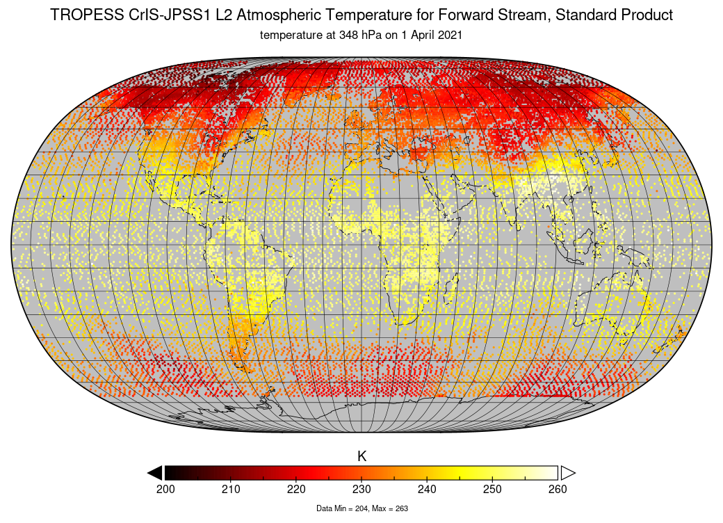
TRPSDL2TATMCRS1FS_Sample.png
-
Data Information (HTML)HTML
TRPSDL2TATMCRS1FS_1.html
-
Data Information (Unknown Format)BIN
-
Data Information (Unknown Format)BIN
-
Data Information (HTML)HTML
contents.html
-
Data Information (PDF)PDF
TROPESS_Forward_Stream_README.pdf
-
Data Information (PDF)PDF
TROPESS-AIRS-CrIS_TATM_L2_Product_User_Guide_v1_20210202.pdf
-
Data Information (PDF)PDF
TROPESS_ATBDv1.1.pdf
-
Data Information (Unknown Format)BIN
-
Landing PageLanding Page
Dates
| Metadata Created Date | April 11, 2025 |
|---|---|
| Metadata Updated Date | September 18, 2025 |
Metadata Source
- Data.json Data.json Metadata
Harvested from NASA Data.json
Additional Metadata
| Resource Type | Dataset |
|---|---|
| Metadata Created Date | April 11, 2025 |
| Metadata Updated Date | September 18, 2025 |
| Publisher | NASA/GSFC/SED/ESD/TISL/GESDISC |
| Maintainer | |
| Identifier | 10.5067/DBWOVPBIHL90 |
| Data Last Modified | 2025-09-11 |
| Category | Earth Science |
| Public Access Level | public |
| Bureau Code | 026:00 |
| Metadata Context | https://project-open-data.cio.gov/v1.1/schema/catalog.jsonld |
| Schema Version | https://project-open-data.cio.gov/v1.1/schema |
| Catalog Describedby | https://project-open-data.cio.gov/v1.1/schema/catalog.json |
| Harvest Object Id | 3c9b97c9-af70-40fd-b4cb-f535962e1137 |
| Harvest Source Id | 58f92550-7a01-4f00-b1b2-8dc953bd598f |
| Harvest Source Title | NASA Data.json |
| Homepage URL | https://docserver.gesdisc.eosdis.nasa.gov/public/project/TROPESS/images/TRPSDL2TATMCRS1FS_Sample.png |
| Old Spatial | "CARTESIAN",{"WestBoundingCoordinate":-180,"NorthBoundingCoordinate":90,"EastBoundingCoordinate":180,"SouthBoundingCoordinate":-90} |
| Program Code | 026:000 |
| Source Datajson Identifier | True |
| Source Hash | 873727312263b45adaa49c8fa52f2b27f32b8d089feee6a76a6f3c472d142a53 |
| Source Schema Version | 1.1 |
| Spatial | |
| Temporal | 2021-04-01/2021-04-01 |
Didn't find what you're looking for? Suggest a dataset here.