
-
Federal
NLDAS Mosaic Land Surface Model L4 Hourly 0.125 x 0.125 degree V2.0 (NLDAS_MOS0125_H) at GES DISC
National Aeronautics and Space Administration —
This data set contains thirty-eight fields simulated from the Mosaic land-surface model (LSM) for Phase 2 of the North American Land Data Assimilation System... -
Federal
GPM DPR (Gridded Convective Stratiform Heating) L3 1.5 hours 0.5 degree x 0.5 degree V07 (GPM_3GCSH) at GES DISC
National Aeronautics and Space Administration —
The Gridded Convective Stratiform Heating (3GCSH) products contain latent heating, Q1-QR and Q2 profiles from DPR raindata.Version 07 is the current version of the... -
Federal
Multi-Satellite Lambertian Equivalent Reflectivity (Local Satellite Time) 10-Day L3 Global 2.0x5.0deg Lat/Lon Grid V1 (MSLERLSTL3d10) at GES DISC
National Aeronautics and Space Administration —
The Multi-Satellite Lambertian Equivalent Reflectivity (Local Satellite Time) 10-Day L3 Global 2.0x5.0deg Lat/Lon Grid data product is derived from multi-satellite... -
Federal
MODIS/Aqua Monthly mean Night-Time Land Surface Temperature at 1x1 degree V005 (MYD11CM1N) at GES DISC
National Aeronautics and Space Administration —
The dataset contains global monthly night-time land surface temperature averaged within 1 by 1 degree grid cells. The source for the data is MODIS/Aqua MYD11C3... -
Federal
HIRS/Nimbus-6 Images of Brightness Temperature on 70 mm Film V001 (HIRSN6IM) at GES DISC
National Aeronautics and Space Administration —
The HIRSN6IM data product consists of images of brightness temperatures on 70 mm film strips from the Nimbus-6 High Resolution Infrared Radiation Sounder. Each... -
Federal
HRIR/Nimbus-1 Images of Nighttime Brightness Temperature on 70 mm Film V001 (HRIRN1IM) at GES DISC
National Aeronautics and Space Administration —
HRIRN1IM is the Nimbus-1 High-Resolution Infrared Radiometer (HRIR) data product containing scanned negatives of photofacsimile 70mm film strips. The images contain... -
Federal
HIRDLS-MLS/Aura Level 3 Monthly 10 x 20 deg Ice Water Content V002 (HIRMLS3IWC) at GES DISC
National Aeronautics and Space Administration —
HIRMLS3IWC is the Joint EOS High Resolution Dynamics Limb Sounder (HIRDLS) and Microwave Limb Sounder (MLS) monthly 10 degreee lat x 20 degreee lon gridded product... -
Federal
MLS/Aura Level 3 Daily Binned Nitric Acid (HNO3) Mixing Ratio on Zonal and Similar Grids V004 (ML3DZHNO3) at GES DISC
National Aeronautics and Space Administration —
ML3DZHNO3 is the EOS Aura Microwave Limb Sounder (MLS) daily binned on zonal and assorted vertical grids product for nitric acid (HNO3) derived from radiances... -
Federal
VISSR/SMS-2 Level 1 Atmospheric and Oceanographic Image Processing System (AOIPS) Data V001 (VISSRSMS2L1AOIPS) at GES DISC
National Aeronautics and Space Administration —
VISSRSMS2L1AOIPS is the Visible Infrared Spin-Scan Radiometer (VISSR) Level 1 Atmospheric and Oceanographic Image Processing System (AOIPS) data product from the... -
Federal
TROPESS CrIS-SNPP L2 Methane for Australian Fires, Standard Product V1 (TRPSDL2CH4CRSAUS) at GES DISC
National Aeronautics and Space Administration —
The TROPESS CrIS-SNPP L2 Methane for Australian Fires, Standard Product contains the vertical distribution of the retrieved atmospheric state of methane (CH4), formal... -
Federal
TROPESS CrIS-SNPP L2 Ammonia for West Coast Fires, Standard Product V1 (TRPSDL2NH3CRSWCF) at GES DISC
National Aeronautics and Space Administration —
The TROPESS CrIS-SNPP L2 Ammonia for West Coast Fires, Standard Product contains the vertical distribution of the retrieved atmospheric state of ammonia (NH3), formal... -
Federal
TROPESS Chemical Reanalysis Surface Pressure Monthly 2-dimensional Product V1 (TRPSCRPSM2D) at GES DISC
National Aeronautics and Space Administration —
The TROPESS Chemical Reanalysis PS Monthly 2-dimensional Product contains surface pressure values, a meteorological field. The data are part of the Tropospheric... -
Federal
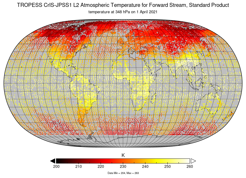
TROPESS CrIS-JPSS1 L2 Atmospheric Temperature for Forward Stream, Standard Product V1 (TRPSDL2TATMCRS1FS) at GES DISC
National Aeronautics and Space Administration —
The TROPESS CrIS-JPSS1 L2 Atmospheric Temperature for Forward Stream, Standard Product contains the vertical distribution of the retrieved atmospheric state of... -
Federal
TROPESS Chemical Reanalysis OH Monthly 3-dimensional Product V1 (TRPSCROHM3D) at GES DISC
National Aeronautics and Space Administration —
The TROPESS Chemical Reanalysis OH Monthly 3-dimensional Product contains vertical concentrations of the hydroxyl radical. The data are part of the Tropospheric... -
Federal
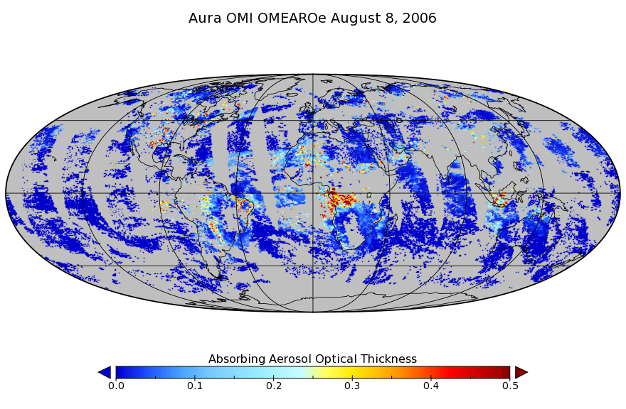
OMI/Aura Multi-wavelength Aerosol Optical Depth and Single Scattering Albedo L3 1 day Best Pixel in 0.25 degree x 0.25 degree V3 (OMAEROe) at GES DISC
National Aeronautics and Space Administration —
The OMI science team produces this Level-3 Aura/OMI Global Aerosol Data Products OMAEROe (0.25deg Lat/Lon grids). The OMAEROe product selects best aerosol value from... -
Federal
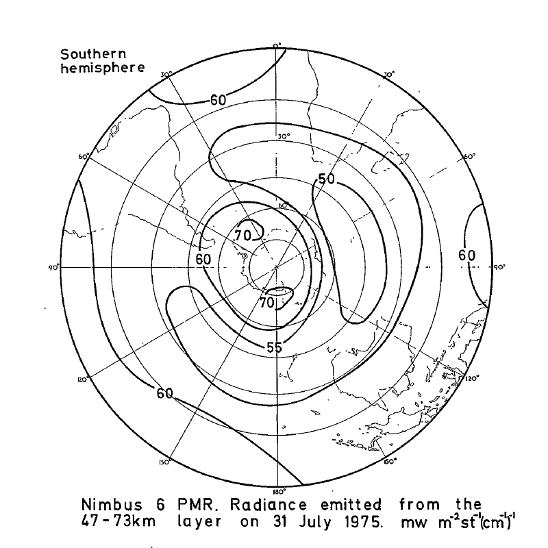
PMR/Nimbus-6 Level 1 Radiance Data from CD-ROM V001 (PMRN6L1RAD_CDROM) at GES DISC
National Aeronautics and Space Administration —
PMRN6L1RAD_CDROM is the gridded Nimbus-6 Pressure Modulated Radiometer (PMR) Level 1 Radiance Data Product. The radiances are measured at CO2 lines in the 15 micron... -
Federal
OMI/Aura TOMS-Like Ozone, Aerosol Index, Cloud Radiance Fraction L3 1 day 1 degree x 1 degree V004 (OMTO3d) at GES DISC
National Aeronautics and Space Administration —
The OMI science team produces this Level-3 daily global TOMS-Like Total Column Ozone gridded product OMTO3d (1 deg Lat/Lon grids). The OMTO3d product is produced by... -
Federal
OMI/Aura Surface UV Irradiance 1-orbit L2 Swath 13x24 km V003 (OMUVB) at GES DISC
National Aeronautics and Space Administration —
The Aura Ozone Monitoring Instrument (OMI) Version 003 Surface UV Irradiance Product (OMUVB) is now available from the NASA Goddard Earth Sciences Data and... -
Federal
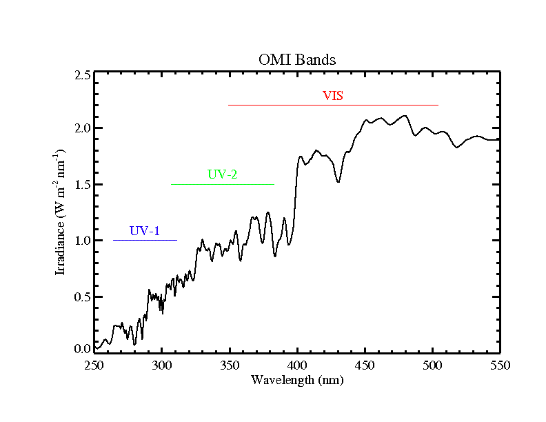
OMI/Aura Level 1B VIS Global Geolocated Earth Shine Radiances 1-orbit L2 Swath 13x24 km V003 (OML1BRVG) at GES DISC
National Aeronautics and Space Administration —
The Aura Ozone Monitoring Instrument (OMI) Level-1B (L1B) Geo-located Earth View VIS Radiance, Global-Mode (OML1BRVG) Version-3 product contains geo-located Earth... -
Federal
OMI/Aura Level 1B VIS Global Geolocated Earthshine Radiances V004 (OML1BRVG) at GES DISC
National Aeronautics and Space Administration —
The Aura Ozone Monitoring Instrument (OMI) Level 1B (L1B) Geolocated Earthshine VIS Radiance, Global-mode (shortname OML1BRVG) Version 4 product contains geolocated...

Official websites use .gov
A
.gov website belongs to an official government
organization in the United States.
Secure .gov websites use HTTPS
A
lock (
) or https:// means you’ve safely connected to
the .gov website. Share sensitive information only on official,
secure websites.