
-
Federal
GPM SSMIS on F17 (GPROF) Climate-based Radiometer Precipitation Profiling 1.5 hours 12 km V07 (GPM_2AGPROFF17SSMIS_CLIM) at GES DISC
National Aeronautics and Space Administration —
Version 07 is the current version of the data set. Older versions will no longer be available and have been superseded by Version 07.The 'CLIM' products differ from... -
Federal
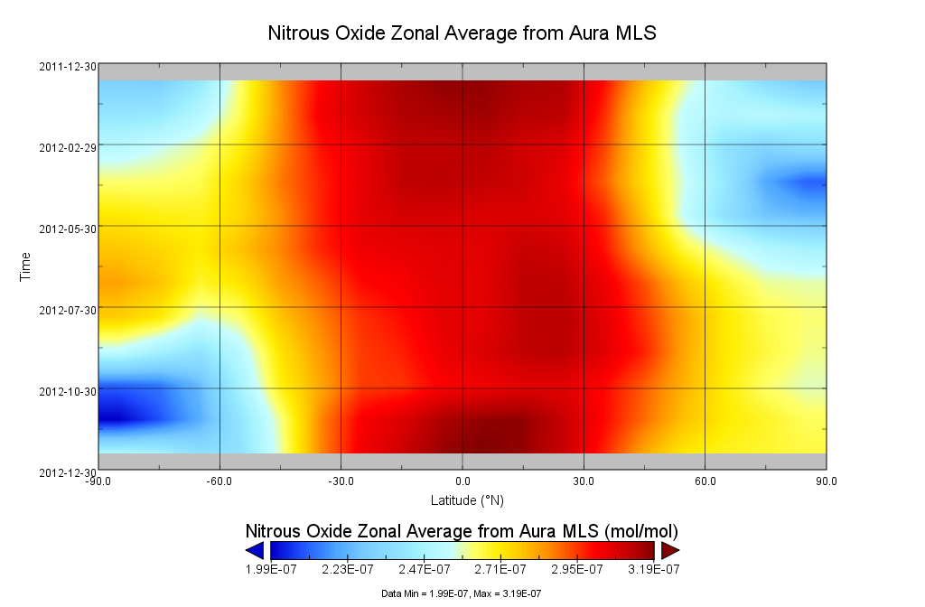
GOZCARDS Source Nitrous Oxide 1 month L3 10 degree Zonal Means on a Vertical Pressure Grid V1 (GozSmlpN2O) at GES DISC
National Aeronautics and Space Administration —
The GOZCARDS Source Data for Nitrous Oxide 1 month L3 10 degree Zonal Averages on a Vertical Pressure Grid product (GozSmlpN2O) contains zonal means and related... -
Federal
GOZCARDS Source Ozone 1 month L3 10 degree Zonal Means on a Vertical Pressure Grid V1 (GozSmlpO3) at GES DISC
National Aeronautics and Space Administration —
The GOZCARDS Source Data for Ozone 1 month L3 10 degree Zonal Averages on a Vertical Pressure Grid product (GozSmlpO3) contains zonal means and related information... -
Federal
GEOS-5 FP-IT 3D Time-Averaged Single-Level Diagnostics Geo-Colocated to OMI/Aura VIS 1-Orbit L2 Swath 13x24km V4 (OMVFPSLV) at GES DISC
National Aeronautics and Space Administration —
The GEOS-5 FP-IT 3D Time-Averaged Single-Level Diagnostics Geo-Colocated to OMI/Aura VIS 1-Orbit L2 Swath 13x24km (OMVFPSLV) provides selected parameters from GEOS-5... -
Federal
GEOS-Carb CASA-GFED 3-hourly Ecosystem Exchange Fluxes 0.5 degree x 0.625 degree V3 (GEOS_CASAGFED_3H_NEE) at GES DISC
National Aeronautics and Space Administration —
This product provides 3 hourly average net ecosystem exchange (NEE) and gross ecosystem exchange (GEE)of Carbon derived from the Carnegie-Ames-Stanford-Approach –... -
Federal
Goddard Satellite-Based Surface Turbulent Fluxes, 1x1 deg Yearly Climatology, Set1 and NCEP V2c (GSSTFYC) at GES DISC
National Aeronautics and Space Administration —
These data are the Goddard Satellite-based Surface Turbulent Fluxes Version-2c Dataset recently produced through a MEaSURES funded project led by Dr. Chung-Lin Shie... -
Federal
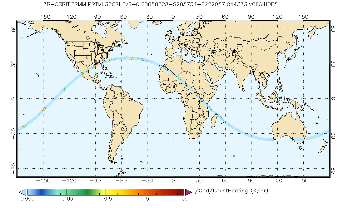
GPM PR and TMI on TRMM Combined Gridded Orbital Convective-Stratiform Latent Heating Profiles L3 1.5 hours 0.25x0.25 degree V07 (GPM_3GCSH_TRMM) at GES DISC
National Aeronautics and Space Administration —
This is the new (GPM-formated) TRMM product. It replaces the old TRMM legacy product TRMM_3G31.Version 07 is the current version of the data set. Older versions will... -
Federal
Annual Summary of Artificial Light At Night from VIIRS/S-NPP at CONUS County and Census Tract V1 (ALAN_VIIRS_CONUS) at GES DISC
National Aeronautics and Space Administration —
This product provides detailed information about the satellite-based data on artificial light at night (ALAN). The Suomi National Polar-orbiting Partnership (S-NPP)... -
Federal
Aqua AIRS-MLS Matchup Indexes V1.0 (AIRS_MLS_IND) at GES_DISC
National Aeronautics and Space Administration —
This dataset is part of MEaSUREs 2012 Program, and represent Aqua/AIRS-Aura/MLS collocation indexes, in netCDF-4 format. These data map AIRS profile indexes to those... -
Federal
MERRA-2 tavgM_2d_lfo_Nx: 2d,Monthly mean,Time-Averaged,Single-Level,Assimilation,Land Surface Forcings 0.625 x 0.5 degree V5.12.4 (M2TMNXLFO) at GES DISC
National Aeronautics and Space Administration —
M2TMNXLFO (or tavgM_2d_lfo_Nx) is a time-averaged 2-dimensional monthly mean data collection in Modern-Era Retrospective analysis for Research and Applications... -
Federal
Explorer-7 Thermal Radiation Experiment Selected White Sensor Temperature (Nighttime) Values V001 (EXP7L1TRTWHT) at GES DISC
National Aeronautics and Space Administration —
Explorer-7 Thermal Radiation Experiment Selected White Sensor Temperature (Nighttime) Values product contains the temperatures measured by the white sensor at night.... -
Federal
GPM SSMIS on F18 Common Calibrated Brightness Temperatures L1C 1.5 hours 12 km V07 (GPM_1CF18SSMIS) at GES DISC
National Aeronautics and Space Administration —
Version 07 is the current version of the data set. Older versions will no longer be available and have been superseded by Version 07.All 1C products have a common L1C... -
Federal
BUV/Nimbus-4 Dark Current Study Master Data V001 (BUVN4L1DCM) at GES DISC
National Aeronautics and Space Administration —
The Nimbus-4 BUV Level-1 Dark Current Study Master Data is derived from the BUV Level 1 Radiance (RUT) product and contains the geophysical indices and... -
Federal
Carbon Monitoring System Carbon Flux Land Prior L4 V3 (CMSFluxLandPrior)
National Aeronautics and Space Administration —
This dataset provides the Prior for the Land Carbon Flux.The NASA Carbon Monitoring System (CMS) is designed to make significant contributions in characterizing,... -
Federal
SNPP VIIRS High Resolution Level 3 daily aerosol data, 0.1x0.1 degree grid Version 001 (AER_DBDT_D10KM_L3_VIIRS_SNPP) at GES DISC
National Aeronautics and Space Administration —
This High-Resolution (0.1 x 0.1 degree) Level 3 daily Aerosol Optical Depth (AOD) product is generated by combining two Visible Infrared Imaging Radiometer Suite... -
Federal
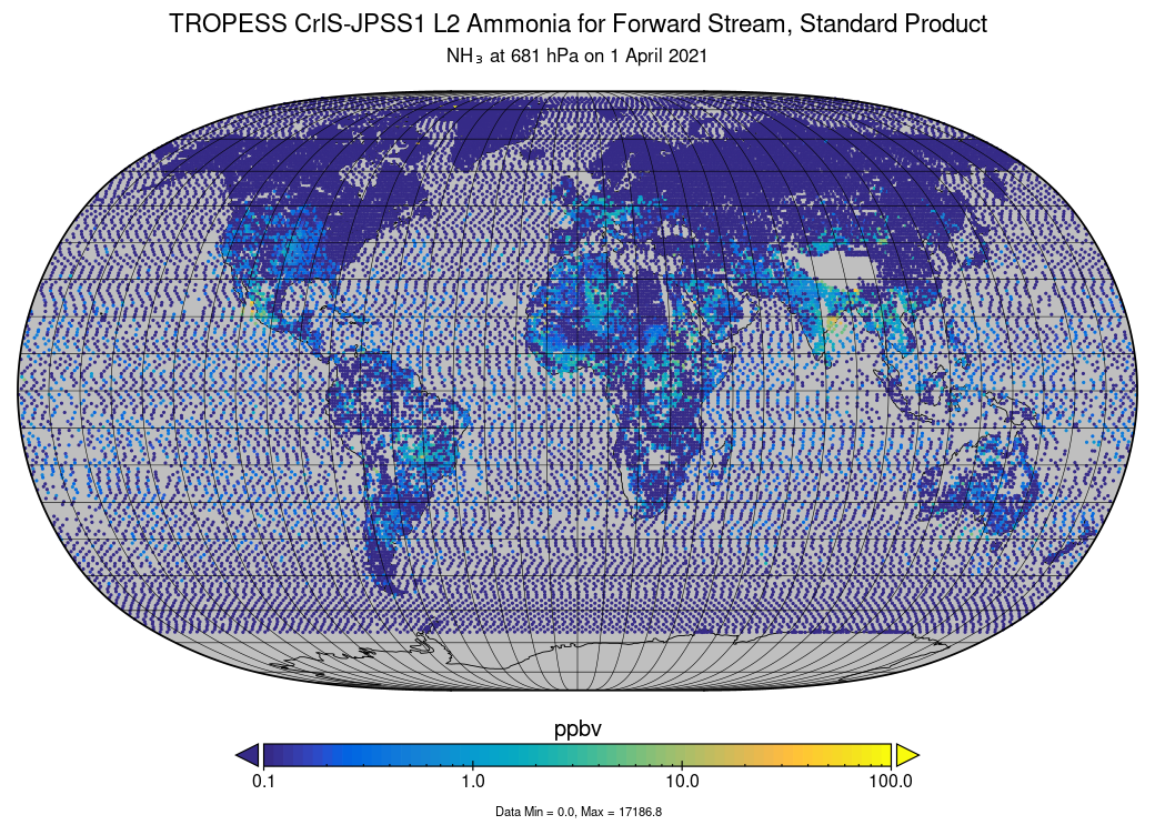
TROPESS CrIS-JPSS1 L2 Ammonia for Forward Stream, Standard Product V1 (TRPSDL2NH3CRS1FS) at GES DISC
National Aeronautics and Space Administration —
The TROPESS CrIS-JPSS1 L2 Ammonia for Forward Stream, Standard Product contains the vertical distribution of the retrieved atmospheric state of ammonia (NH3), formal... -
Federal
TROPESS CrIS-SNPP L2 for Tokyo Megacity, Standard Product V1 (TRPSDL2ALLCRSMGTOK) at GES DISC
National Aeronautics and Space Administration —
The TROPESS CrIS-SNPP L2 for Tokyo Megacity, Standard Product contains the vertical distribution of seven retrieved atmospheric gases (CH4, CO, H2O, HDO, NH3, O3 and... -
Federal
TROPESS CrIS-SNPP L2 for Lagos Megacity, Standard Product V1 (TRPSDL2ALLCRSMGLAG) at GES DISC
National Aeronautics and Space Administration —
The TROPESS CrIS-SNPP L2 for Lagos Megacity, Standard Product contains the vertical distribution of seven retrieved atmospheric gases (CH4, CO, H2O, HDO, NH3, O3 and... -
Federal
Sentinel-5P TROPOMI Radiance product band 8 (SWIR detector) L1B 5.5km x 7km V1 (S5P_L1B_RA_BD8_HiR) at GES DISC
National Aeronautics and Space Administration —
Starting from August 6th in 2019, Sentinel-5P TROPOMI along-track high spatial resolution (~5.5km at nadir) has been implemented.For data before August 6th of 2019,... -
Federal
MERRA-2 tavgU_3d_rad_Np: 3d,diurnal,Time-Averaged,Pressure-Level,Assimilation,Radiation Diagnostics 0.625 x 0.5 degree V5.12.4 (M2TUNPRAD) at GES DISC
National Aeronautics and Space Administration —
M2TUNPRAD (or tavgU_3d_rad_Np) is a 3-dimensional monthly diurnal means data collection in Modern-Era Retrospective analysis for Research and Applications version 2...

Official websites use .gov
A
.gov website belongs to an official government
organization in the United States.
Secure .gov websites use HTTPS
A
lock (
) or https:// means you’ve safely connected to
the .gov website. Share sensitive information only on official,
secure websites.