
-
Federal
ABoVE: Soil Moisture and Active Layer Thickness in Alaska, USA and Canada, 2005-2022
National Aeronautics and Space Administration —
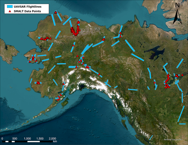
This dataset provides soil thaw depth and moisture measurements and dielectric properties measured by different research teams at sites in Alaska, U.S., and the... -
Federal
AIRS/Aqua L1B Near Real Time (NRT) AMSU (A1/A2) geolocated and calibrated brightness temperatures V005 (AIRABRAD_NRT) at GES DISC
National Aeronautics and Space Administration —
The AMSU-A Level 1B Near Real Time (NRT) product (AIRABRAD_NRT_005) differs from the routine product (AIRABRAD_005) in 2 ways to meet the three hour latency... -
Federal
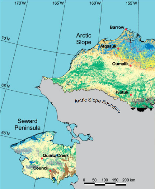
Arctic Vegetation Plots ATLAS Project North Slope and Seward Peninsula, AK, 1998-2000
National Aeronautics and Space Administration —
This data set provides environmental, soil, and vegetation data collected from study sites on the North Slope and Seward Peninsula of Alaska during the Arctic... -
Federal
Aquarius Official Release Level 3 Rain-flagged Sea Surface Salinity Standard Mapped Image Descending Seasonal Climatology Data V5.0
National Aeronautics and Space Administration —
Aquarius Level 3 sea surface salinity (SSS) rain-flagged standard mapped image data contains gridded 1 degree spatial resolution SSS averaged over daily, 7 day,... -
Federal
Arctic Vegetation Plots at Frost Boil Sites, North Slope, Alaska, 2000-2006
National Aeronautics and Space Administration —
This data set describes the environment, soil, and vegetation on nonsorted circles and earth hummocks at seven study sites along a N-S-transect from the Arctic Ocean... -
Federal
AVIRIS-Classic: L1B Calibrated Radiance, Facility Instrument Collection, V1
National Aeronautics and Space Administration —
This dataset contains Level 1B (L1B) orthocorrected, scaled radiance image files as well as files of observational geometry and illumination parameters and supporting... -
Federal
Land Use and Cover Maps from Landsat, Mawas, Central Kalimantan, Indonesia, 1994-2019
National Aeronautics and Space Administration —
This dataset contains annual land use/cover (LUC) maps at 30 m resolution across Mawas, Central Kalimantan, Indonesia. There are six files, each representing a five-... -
Federal
Arctic Vegetation Plots at Atqasuk, Alaska, 1975, 2000, and 2010
National Aeronautics and Space Administration —
This data set provides vegetation species abundance data collected in 1975 from 60 sites on the Arctic Coastal Plain near Atqasuk, Alaska, as well as environmental... -
Federal
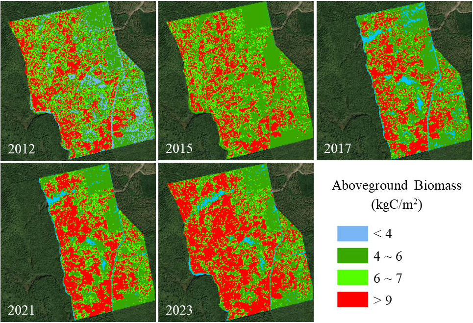
Aboveground Biomass for Howland Forest, Maine, 2012-2023
National Aeronautics and Space Administration —
This dataset holds aboveground biomass (AGB) estimates at 10-m spatial resolution for the Howland Research Forest in central Maine for 2012, 2015, 2017, 2021, and... -
Federal
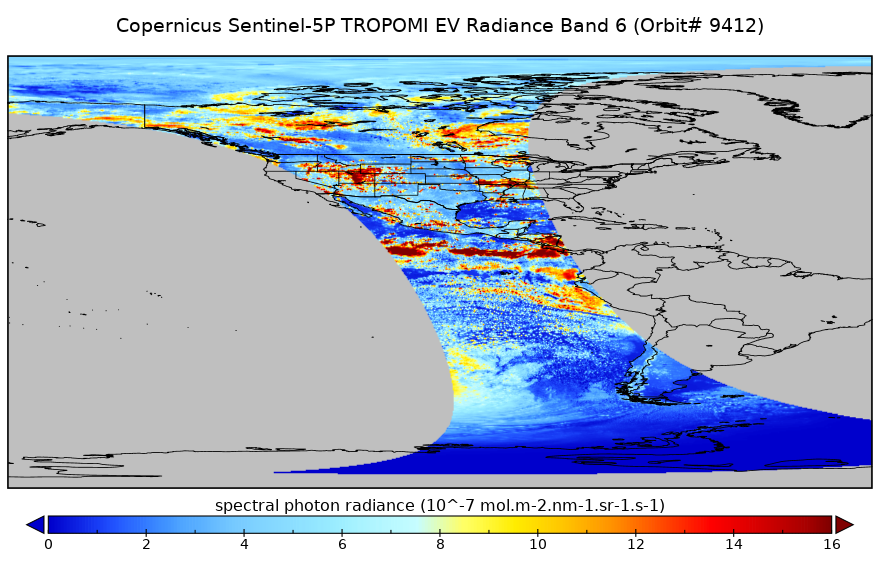
Sentinel-5P TROPOMI Radiance product band 6 (NIR detector) L1B 5.5km x 3.5km V1 (S5P_L1B_RA_BD6_HiR) at GES DISC
National Aeronautics and Space Administration —
Starting from August 6th in 2019, Sentinel-5P TROPOMI along-track high spatial resolution (~5.5km at nadir) has been implemented. For data before August 6th of 2019,... -
Federal
MODIS/Terra Land Surface Temperature/Emissivity Daily L3 Global 6km SIN Grid V061
National Aeronautics and Space Administration —
The Terra Moderate Resolution Imaging Spectroradiometer (MODIS) Land Surface Temperature/Emissivity Daily(MOD11B1) Version 6.1 product provides daily per pixel Land... -
Federal
MODIS/Aqua Aerosol Cloud Water Vapor Ozone Monthly L3 Global 1Deg CMG
National Aeronautics and Space Administration —
The MODIS/Aqua Aerosol Cloud Water Vapor Ozone Monthly L3 Global 1Deg CMG product (MYD08_M3) contains monthly 1 x 1 degree grid average values of atmospheric... -
Federal
Earth Radiation Budget Experiment (ERBE) S-4G Nonscanner,Medium Field of View (MFOV) Numerical Filter (NF) Zonal and Global Averages in HDF
National Aeronautics and Space Administration —
ERBE_S4G_MFOV_NF_ZG_1 is the Earth Radiation Budget Experiment (ERBE) S-4G Non-scanner, Medium Field of View (MFOV) Numerical Filter (NF) Zonal and Global Averages in... -
Federal
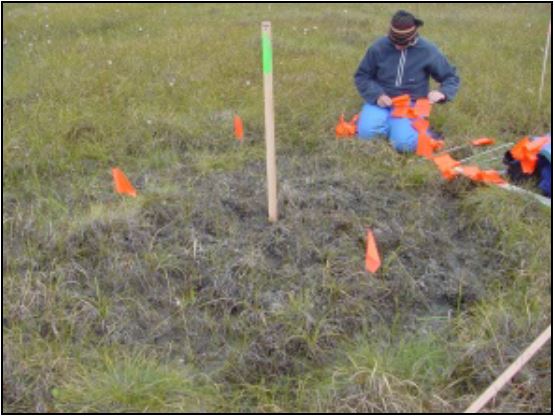
BOREAS HYD-06 Ground Gravimetric Soil Moisture Data
National Aeronautics and Space Administration —
This data set contains percent soil moisture ground measurements. These data were collected on the ground along the various flight lines flown in the Southern and... -
Federal
BOREAS RSS-14 Level-3 Gridded Radiometer and Satellite Surface Radiation Images
National Aeronautics and Space Administration —
The BOREAS RSS-14 team collected and processed GOES-7 and -8 images of the BOREAS region as part of their effort to characterize the incoming, reflected and emitted... -
Federal
BOREAS RSS-20 POLDER C-130 Measurements of Surface BRDF
National Aeronautics and Space Administration —
This data set contains measurements of surface BRDF made by the POLDER instrument over several surface types (pine, spruce, fen) of the BOREAS SSA during the 1994... -
Federal
Aqua AIRS-MLS Matchup Indexes V1.0 (AIRS_MLS_IND) at GES_DISC
National Aeronautics and Space Administration —
This dataset is part of MEaSUREs 2012 Program, and represent Aqua/AIRS-Aura/MLS collocation indexes, in netCDF-4 format. These data map AIRS profile indexes to those... -
Federal
SWOT Level 2 Lake Single-Pass Vector Obs Data Product, Version D
National Aeronautics and Space Administration —
The SWOT Level 2 Lake Single-Pass Vector Product (SWOT_L2_HR_LakeSP_D) provides geolocated surface water measurements for lakes and unclassified water bodies, derived... -
Federal
GLDAS Noah Land Surface Model L4 monthly 1.0 x 1.0 degree V2.0 (GLDAS_NOAH10_M) at GES DISC
National Aeronautics and Space Administration —
NASA Global Land Data Assimilation System Version 2 (GLDAS-2) has three components: GLDAS-2.0, GLDAS-2.1, and GLDAS-2.2. GLDAS-2.0 is forced entirely with the... -
Federal
Hurricane and Severe Storm Sentinel (HS3) Statistical Hurricane Intensity Prediction Scheme (SHIPS) Intensity V1
National Aeronautics and Space Administration —
The Hurricane and Severe Storm Sentinel (HS3) Statistical Hurricane Intensity Prediction Scheme (SHIPS) Intensity dataset was obtained from March 18, 2014 through...

Official websites use .gov
A
.gov website belongs to an official government
organization in the United States.
Secure .gov websites use HTTPS
A
lock (
) or https:// means you’ve safely connected to
the .gov website. Share sensitive information only on official,
secure websites.