
-
Federal
Permafrost Map of Alaska, USA, Version 1
National Aeronautics and Space Administration —
This data set consists of a geo-referenced digital map and attribute data derived from the publication 'Permafrost map of Alaska'. The map is presented at a scale of... -
Federal
NAAMES R/V Atlantis Miscellaneous Data, Version 1
National Aeronautics and Space Administration —
NAAMES_Misc_Ship_Data are miscellaneous ship measurements collected onboard the R/V Atlantis vessel during the North Atlantic Aerosols and Marine Ecosystems Study... -
Federal
CALIPSO Lidar Level 2 Vertical Feature Mask (VFM), V4-51
National Aeronautics and Space Administration —
CAL_LID_L2_VFM-Standard-V4-21 is the Cloud-Aerosol Lidar and Infrared Pathfinder Satellite Observations (CALIPSO) Lidar Level 2 Vertical Feature Mask (VFM), Version... -
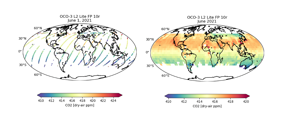
Federal
OCO-3 Level 2 bias-corrected XCO2 and other select fields from the full-physics retrieval aggregated as daily files, Retrospective processing V11r (OCO3_L2_Lite_FP) at GES DISC
National Aeronautics and Space Administration —
Version 11r is the current version of the data set. Older versions will no longer be available and are superseded by Version 11r. The Orbiting Carbon Observatory -3... -
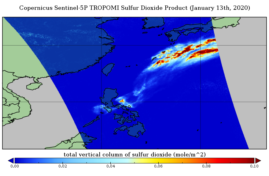
Federal
Sentinel-5P TROPOMI Sulphur Dioxide SO2 1-Orbit L2 5.5km x 3.5km V1 (S5P_L2__SO2____HiR) at GES DISC
National Aeronautics and Space Administration —
Starting from August 6th in 2019, Sentinel-5P TROPOMI along-track high spatial resolution (~5.5km at nadir) has been implemented. Starting from July 13th in 2020,... -
Federal
MODIS/Terra Leaf Area Index/FPAR 8-Day L4 Global 500m SIN Grid V061
National Aeronautics and Space Administration —
The MOD15A2H Version 6.1 Moderate Resolution Imaging Spectroradiometer (MODIS) combined Leaf Area Index (LAI) and Fraction of Photosynthetically Active Radiation... -
Federal
AMSU/MSU Tropopause Day/Month Temperature Anomalies and Annual Cycle V6
National Aeronautics and Space Administration —
The AMSU/MSU Tropopause Day/Month Temperature Anomalies and Annual Cycle V6 dataset consists of temperature anomalies and annual cycle temperatures derived from the... -
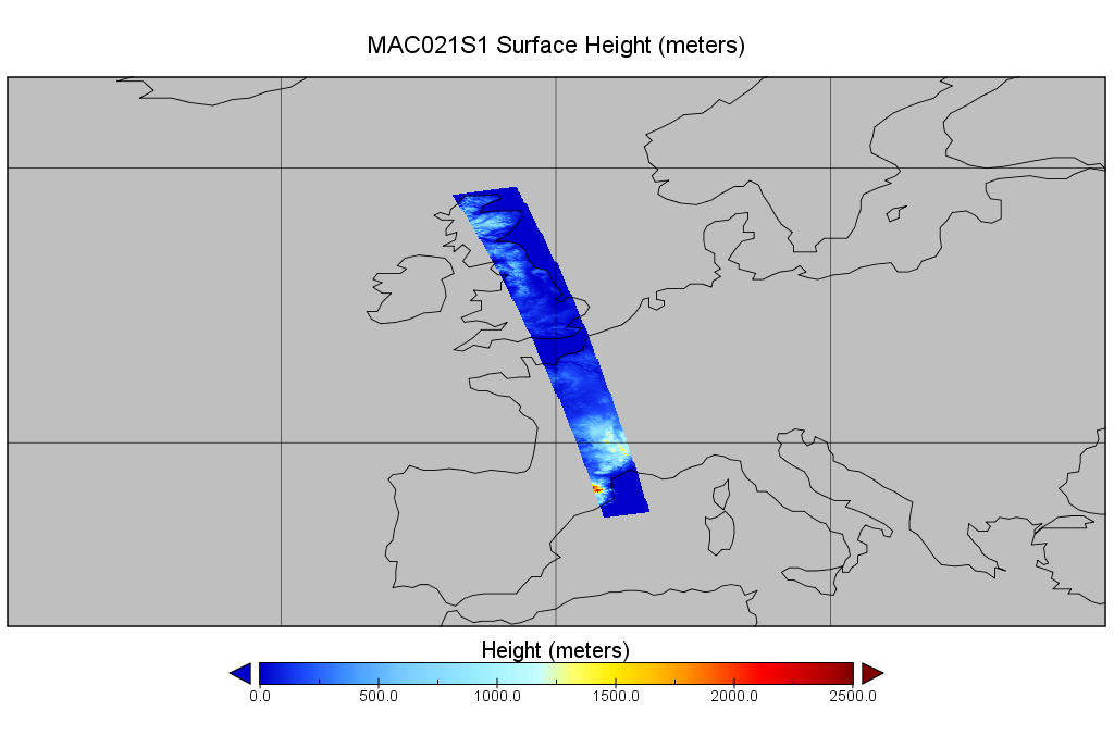
Federal
MODIS/Aqua Calibrated Radiances 250m 5-Min L1B Wide Swath Subset along CloudSat V002 (MAC02QS1) at GES DISC
National Aeronautics and Space Administration —
This is the wide-swath MODIS/Aqua subset along CloudSat field of view track. The goal of the wide-swath subset is to select and return MODIS data that are within... -
Federal
ASTER Orthorectified Digital Elevation Model (DEM) V003
National Aeronautics and Space Administration —
The Terra Advanced Spaceborne Thermal Emission and Reflection Radiometer (ASTER) Digital Elevation Model and Orthorectified Registered Radiance at the Sensor... -
Federal
BOREAS TE-06 Allometry Data
National Aeronautics and Space Administration —
The BOREAS TE-06 team collected several data sets in support of its efforts to characterize and interpret information on the plant biomass, allometry, biometry,... -
Federal
ISLSCP II FASIR-adjusted NDVI Biophysical Parameter Fields, 1982-1998
National Aeronautics and Space Administration —
The Fourier-Adjusted, Sensor and Solar zenith angle corrected, Interpolated, Reconstructed (FASIR) adjusted Normalized Difference Vegetation Index (NDVI) data set and... -
Federal
Amazon Forest Structure from Airborne Lidar, ED2 Initial Condition Files, 2016
National Aeronautics and Space Administration —
This dataset provides initial condition files for initializing the Ecosystem Demography Model (ED2). This dataset holds regional forest structure characteristics... -
Federal
Aqua MODIS Level-3 Global Binned 11µm Nighttime Sea Surface Temperature (NSST) - Near Real-time (NRT) Data, version R2019.0
National Aeronautics and Space Administration —
The Ocean Biology DAAC produces near real-time (quicklook) products using the best-available combination of ancillary data from meteorological and ozone data. As... -
Federal
Aqua MODIS Level-2 Regional 4µm Day/Night Sea Surface Temperature (SST4) - Near Real-time (NRT) Data, version R2019.0
National Aeronautics and Space Administration —
The Ocean Biology DAAC produces near real-time (quicklook) products using the best-available combination of ancillary data from meteorological and ozone data. As... -
Federal
Satellite Laser Ranging (SLR) ILRS Analysis Center (AC) Orbit Product (weekly files, generated weekly) from NASA CDDIS
National Aeronautics and Space Administration —
This derived product set consists of Satellite Laser Ranging Final Orbit Product (weekly files, generated weekly) from the NASA Crustal Dynamics Data Information... -
Federal
Aquarius CAP Level 3 Wind Speed Standard Mapped Image 7-Day Data V5.0
National Aeronautics and Space Administration —
Version 5.0 Aquarius CAP Level 3 products are the fourth release of the AQUARIUS/SAC-D mapped salinity and wind speed data based on the Combined Active Passive (CAP)... -
Federal
Aquarius Celestial Sky Microwave Emission Map Ancillary Dataset V1.0
National Aeronautics and Space Administration —
This datasets contains three maps of L-band (wavelength = 21 cm) brightness temperature of the celestial sky ("Galaxy") used in the processing of the NASA Aquarius... -
Federal
NAMMA CVI CLOUD CONDENSED WATER CONTENT V1
National Aeronautics and Space Administration —
In the NAMMA CVI Cloud Condensed Water Content dataset the counterflow virtual impactor (CVI) was used to measure condensed water content (liquid water or ice in... -
Federal
CLPX-Airborne: Infrared Orthophotography and Lidar Topographic Mapping, Version 1
National Aeronautics and Space Administration —
The data set consists of color infrared orthophotography (TerrainVision® - High resolution Topographic Mapping & Aerial Photography, with 6-inch pixel... -
Federal
ALOS PALSAR Level 1.5 Product
National Aeronautics and Space Administration —
ALOS PALSAR Level 1.5

Official websites use .gov
A
.gov website belongs to an official government
organization in the United States.
Secure .gov websites use HTTPS
A
lock (
) or https:// means you’ve safely connected to
the .gov website. Share sensitive information only on official,
secure websites.