
-
Federal
Delta-X: Delft3D Sediment Model, Site 294, Terrebonne Basin, MRD, Louisiana, USA
National Aeronautics and Space Administration —
This dataset contains the Delft3D model of the intensive site 294 in the Terrebonne Basin along the Mississippi River Delta (MRD) in coastal Louisiana. Simulations... -
Federal
Global Soil Data Products CD-ROM Contents (IGBP-DIS)
National Aeronautics and Space Administration —
This dataset contains global data on soil properties, global maps of soil distributions, and the SoilData System developed by the International Geosphere-Biosphere... -
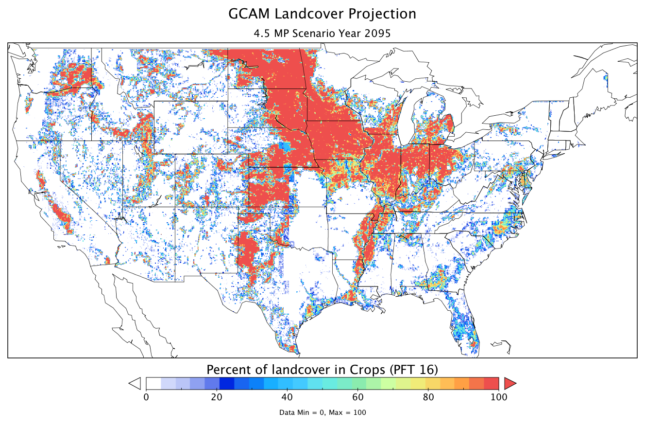
Federal
CMS: Land Cover Projections (5.6-km) from GCAM v3.1 for Conterminous USA, 2005-2095
National Aeronautics and Space Administration —
The data provided are annual land cover projections for years 2005 through 2095 generated by the Global Change Assessment Model (GCAM) Version 3.1. For the... -
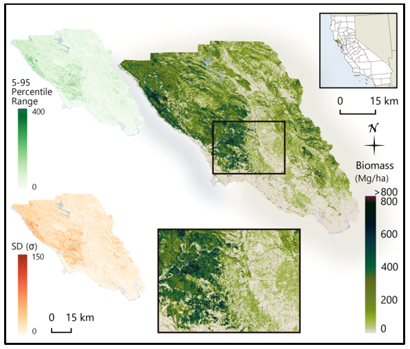
Federal
CMS: LiDAR-derived Biomass, Canopy Height and Cover, Sonoma County, California, 2013
National Aeronautics and Space Administration —
This data set provides estimates of above-ground biomass (AGB), canopy height, and percent tree cover at 30-m spatial resolution for Sonoma County, California, USA,... -
Federal
CMS: LiDAR Biomass Improved for High Biomass Forests, Sonoma County, CA, USA, 2013
National Aeronautics and Space Administration —
This data set provides estimates of above-ground woody biomass and uncertainty at 30-m spatial resolution for Sonoma County, California, USA, for the nominal year... -
Federal
CARVE: L1 In-situ Carbon and CH4 Flux and Meteorology at EC Towers, Alaska, 2011-2015
National Aeronautics and Space Administration —
This data set provides ground in situ flux and meteorological science data from fixed instruments at three eddy covariance tower sites located in the Alaskan Arctic... -
Federal
CARVE: Fire-Related Aerosol and Soil Elemental and Isotopic Composition, Alaska, 2013
National Aeronautics and Space Administration —
This data set provides measurements of the isotopic composition of black carbon and organic carbon aerosols collected at two locations in interior Alaska during the... -
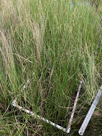
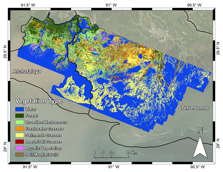
Federal
Delta-X AVIRIS-NG L3 Derived Vegetation Types, MRD, Louisiana, USA
National Aeronautics and Space Administration —
This dataset provides maps of vegetation types for the Atchafalaya and Terrebonne basins in coastal Louisiana, U.S., derived from NASA's Next Generation Airborne... -
Federal
Bowen Ratio Surf. Flux: Fritschen (FIFE)
National Aeronautics and Space Administration —
Surface flux measurements were made at selected sites within the FIFE area. Each surface flux station was capable of measuring the fluxes of net radiation, sensible... -
Federal
Bowen Ratio Surface Flux: UNL (FIFE)
National Aeronautics and Space Administration —
The Bowen Ratio Surface Flux Observations (UNL) Data Set contains surface flux and micrometeorolgical measurements collected at one location located in a flat area of... -
Federal
Bowen Ratio Surface Flux: USGS (FIFE)
National Aeronautics and Space Administration —
The Bowen Ratio Surface Flux Observations (USGS) Data Set contains surface flux and micrometeorological collected from one location within the Northwest quadrant of... -
Federal
Bowen Ratio Surface Flux: GSFC (FIFE)
National Aeronautics and Space Administration —
The Bowen Ratio Surface Flux Observations (GSFC) Data Set contains data collected using the Bowen Ratio Techniques. The major data collection effort was conducted in... -
Federal
Boundary Layer Heights: SODAR (FIFE)
National Aeronautics and Space Administration —
The acoustic sounder (SODAR) maps the amplitude of backscattered acoustic energy associated with temperature fluctuations and thus thermal inversions in the... -
Federal
BOREAS RSS-12 Airborne Tracking Sunphotometer Measurements (C-130)
National Aeronautics and Space Administration —
The BOREAS RSS-12 team collected both ground and airborne sunphotometer measurements for use in characterizing the aerosol optical properties of the atmosphere during... -
Federal
BOREAS RSS-10 TOMS Circumpolar One-Degree PAR Images
National Aeronautics and Space Administration —
The BOREAS RSS-10 team investigated the magnitude of daily, seasonal, and yearly variations of PAR from ground and satellite observations. This data set contains... -
Federal
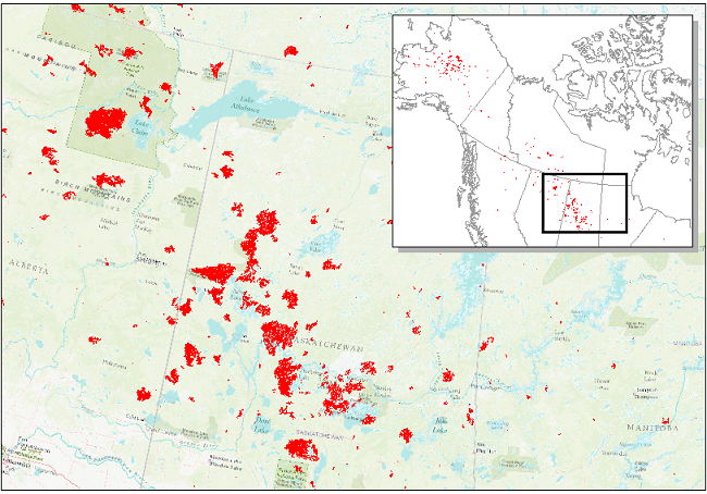
ABoVE: Wildfire Date of Burning within Fire Scars across Alaska and Canada, 2001-2019
National Aeronautics and Space Administration —
This dataset provides estimates of wildfire progression represented by date of burning (DoB) within fire scars across Alaska and Canada for the period 2001-2019. Burn... -
Federal
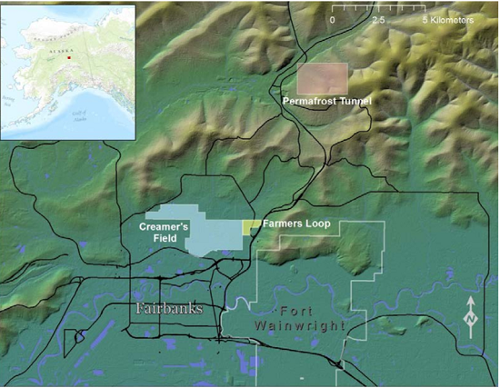
ABoVE: Historical Lake Shorelines and Areas near Fairbanks, Alaska from 1949-2009
National Aeronautics and Space Administration —
This dataset includes maps of historical lake shorelines with derived lake areas in the southern portion of the Goldstream Valley and the surrounding landscape north... -
Federal
ABoVE: Active Layer Soil Characteristics at Selected Sites Across Alaska
National Aeronautics and Space Administration —
This dataset provides soil active layer characteristics from nine locations across Alaska. Soil samples were collected in 2016 except for one site which was sampled...

Official websites use .gov
A
.gov website belongs to an official government
organization in the United States.
Secure .gov websites use HTTPS
A
lock (
) or https:// means you’ve safely connected to
the .gov website. Share sensitive information only on official,
secure websites.