
-
Federal
BLM NM REGION CadNSDI FIRST DIVISION FOR KS
Department of the Interior —
This data represents the GIS Version of the Public Land Survey System including both rectangular and non-rectangular survey data. The rectangular survey data are a... -
Federal
BLM OR FIRE 1940 POLY Hub
Department of the Interior —
FIRE1940_POLY: A series of four maps showing the state of forests in the northern coastal area of Oregon. They show the change in stand age over time due to fires.... -
Federal
BLM Natl Wild Horse and Burro Herd Mgmt Area Polygons
Department of the Interior —
Feature Class for BLM Wild Horse and Burro Herd Areas. Herd Areas were designated in 1971 as places where wild horses and/or burros were found during the initial... -
Federal
BLM OR Wild Horse and Burro Herd Area Polygons Hub
Department of the Interior —
whb_ha_poly: Polygon features depicting the original Wild Horse and Burro Herd Areas. User note: Herd Areas are spatially distinct from Herd Management areas and may... -
Federal
BLM OR Quads 63k Polygon Hub
Department of the Interior —
QUADS30M_POLY: This theme shows the 1:63,360 quadrangles (30 Minute Quads) for Oregon and Washington as defined in North American Datum 1927 (NAD27). These quads show... -
Federal
BLM OR Visual Resource Management Polygon Hub
Department of the Interior —
VRM_POLY: Visual Resources are a landscape characteristic and evaluated using a baseline of the natural, unaltered landscape. Visual Resource Inventory (VRI) is the... -
Federal
BLM OR Wilderness Study Area Polygon Hub
Department of the Interior —
WSA_POLY: This data set represents Wilderness Study Area (WSA) boundaries as inventoried in the mid1980's and defined in the October 1991 "Wilderness Study Report".... -
Federal
Reconnaissance Sediment Sampling within the Anniston Polychlorinated Biphenyl Assessment Area Downstream of Choccolocco Creek, Alabama
Department of the Interior —
Sediment chemical analysis, Coosa River, Alabama -
Federal
Multi-Satellite Lambertian Equivalent Reflectivity (Local Satellite Time) 1 day L3 Global 5.0deg Lat Zones V1 (MSLERLSTL3zm) at GES DISC
National Aeronautics and Space Administration —
The Multi-Satellite Lambertian Equivalent Reflectivity (Local Satellite Time) 1 day L3 Global 5.0deg Lat Zones data product (MSLERLSTL3zm) is derived from... -
Federal
SCMR/Nimbus-5 Level 1 Calibrated and Geolocated Radiances V001 (SCMRN5L1RAD) at GES DISC
National Aeronautics and Space Administration —
SCMRN5L1RAD is the Nimbus-5 Surface Composition Mapping Radiometer (SCMR) Level 1 Calibrated and Geolocated Radiances data product. SCMR measured (1) terrestrial... -
Federal
IRIS/Nimbus-4 Level 1 Radiance Data V001 (IRISN4RAD) at GES DISC
National Aeronautics and Space Administration —
The Nimbus-4 Infrared Interferometer Spectrometer (IRIS) Level 1 Radiance Data contain thermal emissions of the Earth's atmosphere at wave numbers between 400 and... -
Federal
HRIR/Nimbus-3 Level 1 Meteorological Radiation Data V001 (HRIRN3L1) at GES DISC
National Aeronautics and Space Administration —
HRIRN3L1 is the High Resolution Infrared Radiometer (HRIR) Nimbus-3 Level 1 Meteorological Radiance Data (NMRT) product and contains infrared radiances converted to... -
Federal
HRIR/Nimbus-1 Level 1 Meteorological Radiation Data V001 (HRIRN1L1) at GES DISC
National Aeronautics and Space Administration —
HRIRN1L1 is the High Resolution Infrared Radiometer (HRIR) Nimbus-1 Level 1 Meteorological Radiance Data (NMRT) product and contains infrared radiances converted to... -
Federal
LRIR/Nimbus-6 Level 2 Inverted Profiles of Temperature and Ozone V001 (LRIRN6L2IPAT) at GES DISC
National Aeronautics and Space Administration —
LRIRN6L2IPAT is the Nimbus-6 Limb Radiance Inversion Radiometer (LRIR) Level 2 Inverted Profiles of Temperature and Ozone data product. The product contains daily... -
Federal
Nimbus-6 Level 2 NMC Data Systems Test for the Global Atmospheric Research Program (GARP) V001 (NMCN6L2GARP) at GES DISC
National Aeronautics and Space Administration —
The NMCN6L2GARP is the Nimbus-6 Level 2 NMC Data Systems Test for the Global Atmospheric Research Program (GARP) product. The product consists of meterological... -
Federal
SAMS/Nimbus-7 Level 3 Gridded Retrieval Temperature Data V001 (SAMSN7L3GRIDT) at GES DISC
National Aeronautics and Space Administration —
SAMSN7L3GRIDT is the Nimbus-7 Stratospheric and Mesospheric Sounder (SAMS) Level 3 Gridded Retrieval Temperature Data Product. The Earth's surface is divided into 2.5... -
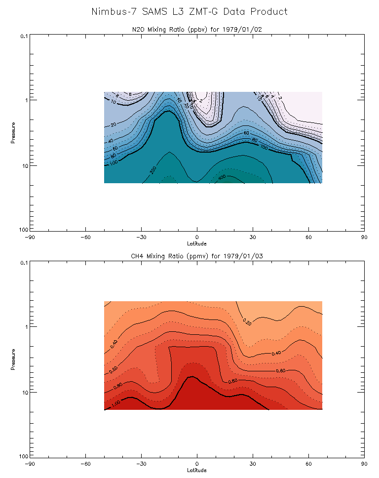
Federal
SAMS/Nimbus-7 Level 3 Zonal Means Composition Data V001 (SAMSN7L3ZMTG) at GES DISC
National Aeronautics and Space Administration —
SAMSN7L3ZMTG is the Nimbus-7 Stratospheric and Mesospheric Sounder (SAMS) Level 3 Zonal Means Composition Data Product. The Earth's surface is divided into 2.5-deg... -
Federal
VISSR/SMS-1 Level 1 Experimenter History Data V001 (VISSRSMS1L1EHT) at GES DISC
National Aeronautics and Space Administration —
VISSRSMS1L1EHT is the Visible Infrared Spin-Scan Radiometer (VISSR) Level 1 Experimenter History Tape (EHT) data product from the first Synchronous Meteorological... -
Federal
TIROS-4 Medium-Resolution Scanning Radiometer Level 1 Final Meteorological Radiation Data V001 (TIROS4L1FMRT) at GES DISC
National Aeronautics and Space Administration —
TIROS-4 Medium-Resolution Scanning Radiometer Level 1 Final Meteorological Radiation Data (FMRT) product contains radiances expressed in five infrared/visible... -
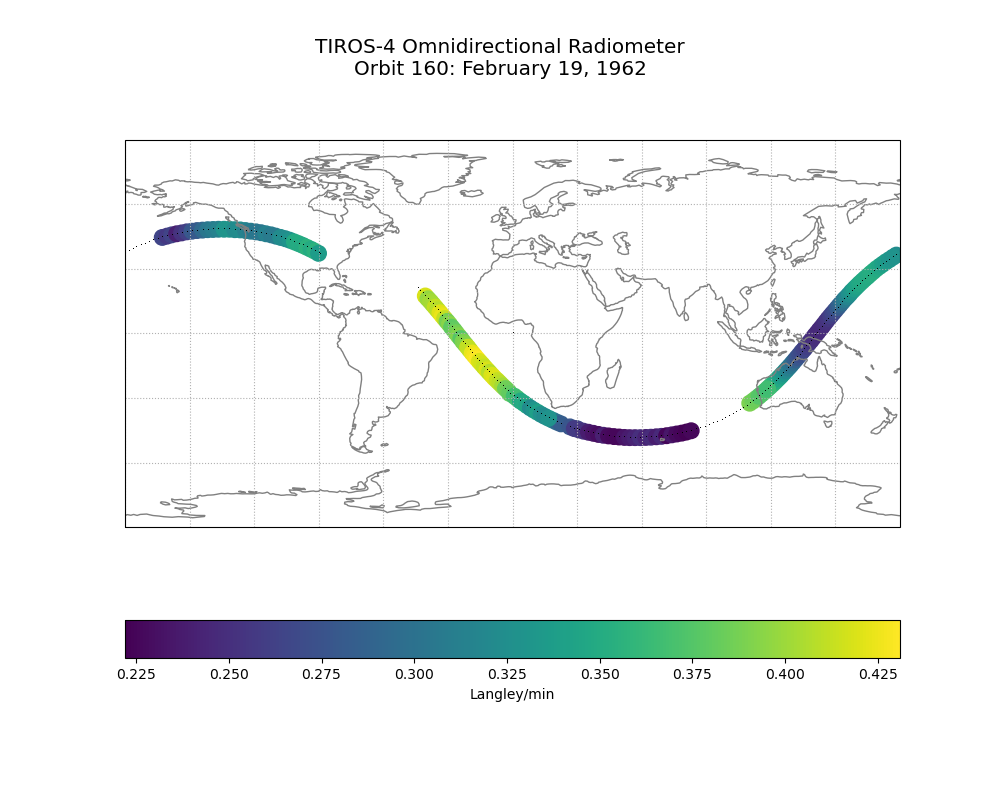
Federal
TIROS-4 Low-Resolution Omnidirectional Radiometer Level 1 Radiance Data V001 (TIROS4L1ORR) at GES DISC
National Aeronautics and Space Administration —
The TIROS-4 Low-Resolution Omnidirectional Radiometer Level 1 Radiance Data product contains the longwave radiation values in Langleys/min derived from the black and...

Official websites use .gov
A
.gov website belongs to an official government
organization in the United States.
Secure .gov websites use HTTPS
A
lock (
) or https:// means you’ve safely connected to
the .gov website. Share sensitive information only on official,
secure websites.