
-
Federal
Sentinel-6A MF Jason-CS L2 P4 Altimeter Low Resolution (LR) STC Reduced Ocean Surface Topography
National Aeronautics and Space Administration —
Provides low resolution (LR) short time critical (STC; 36-hour latency) measurements of sea surface height anomaly (SSHA), Significant Wave Height (SWH), and Wind... -
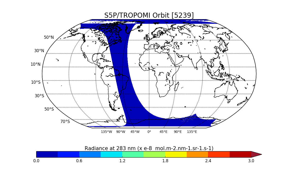
Federal
Sentinel-5P TROPOMI Radiance product band 1 (UV detector) L1B V1 (S5P_L1B_RA_BD1) at GES DISC
National Aeronautics and Space Administration —
Starting from August 6th in 2019, Sentinel-5P TROPOMI along-track high spatial resolution (~5.5km at nadir) has been implemented. For data after August 6th of 2019,... -
Federal
Sentinel-1C Single Polarization High Resolution Ground Range Detected Product
National Aeronautics and Space Administration —
The Sentinel-1C satellite was launched December 5, 2024. Sentinel-1C is the the latest satellite to be added to the Sentinel-1 constellation. The Sentinel-1... -
Federal
SENTINEL-1B_SINGLE_POL_GRD_MEDIUM_RES
National Aeronautics and Space Administration —
Sentinel-1B Single-pol ground projected medium resolution images -
Federal
SMEX04 Bulk Density and Rock Fraction Data: Arizona, Version 1
National Aeronautics and Space Administration —
Notice to Data Users: The documentation for this data set was provided solely by the Principal Investigator(s) and was not further developed, thoroughly reviewed, or... -
Federal
Measurements onboard the Russian R/V Akademik Sergey Vavilov
National Aeronautics and Space Administration —
Measurements from the Barents Sea north of Russia made during 1998 by the Russian research vessel, the Akademik Sergey Vavilov. -
Federal
MISR Level 3 FIRSTLOOK Component Global Radiance Product covering a month V002
National Aeronautics and Space Administration —
This file contains the MISR Level 3 FIRSTLOOK Component Global Radiance Product covering a month. MI3MRDF_002 is the Multi-angle Imaging SpectroRadiometer (MISR)... -
Federal
MISR Level 3 Component Global Radiance Product covering a month subset for the UAE region V005
National Aeronautics and Space Administration —
UAEMRMRD_005 is the Multi-angle Imaging SpectroRadiometer (MISR) Level 3 Component Global Radiance Product covering a month subset for the UAE region version 5. It... -
Federal
Measurements made in the west-central Pacific near Wake Island
National Aeronautics and Space Administration —
Measurements made in the west-central Pacific near Wake Island in 2007. -
Federal
Lidar Atmospheric Sensing Experiment (LASE) Data Obtained During the Southern Great Plains (SGP97) Field Experiment
National Aeronautics and Space Administration —
The LASE Southern Great Plains (SGP97) field experiment was conducted in Oklahoma during June-July 1997. SGP97 was a NASA EOS Interdisciplinary Science Investigation... -
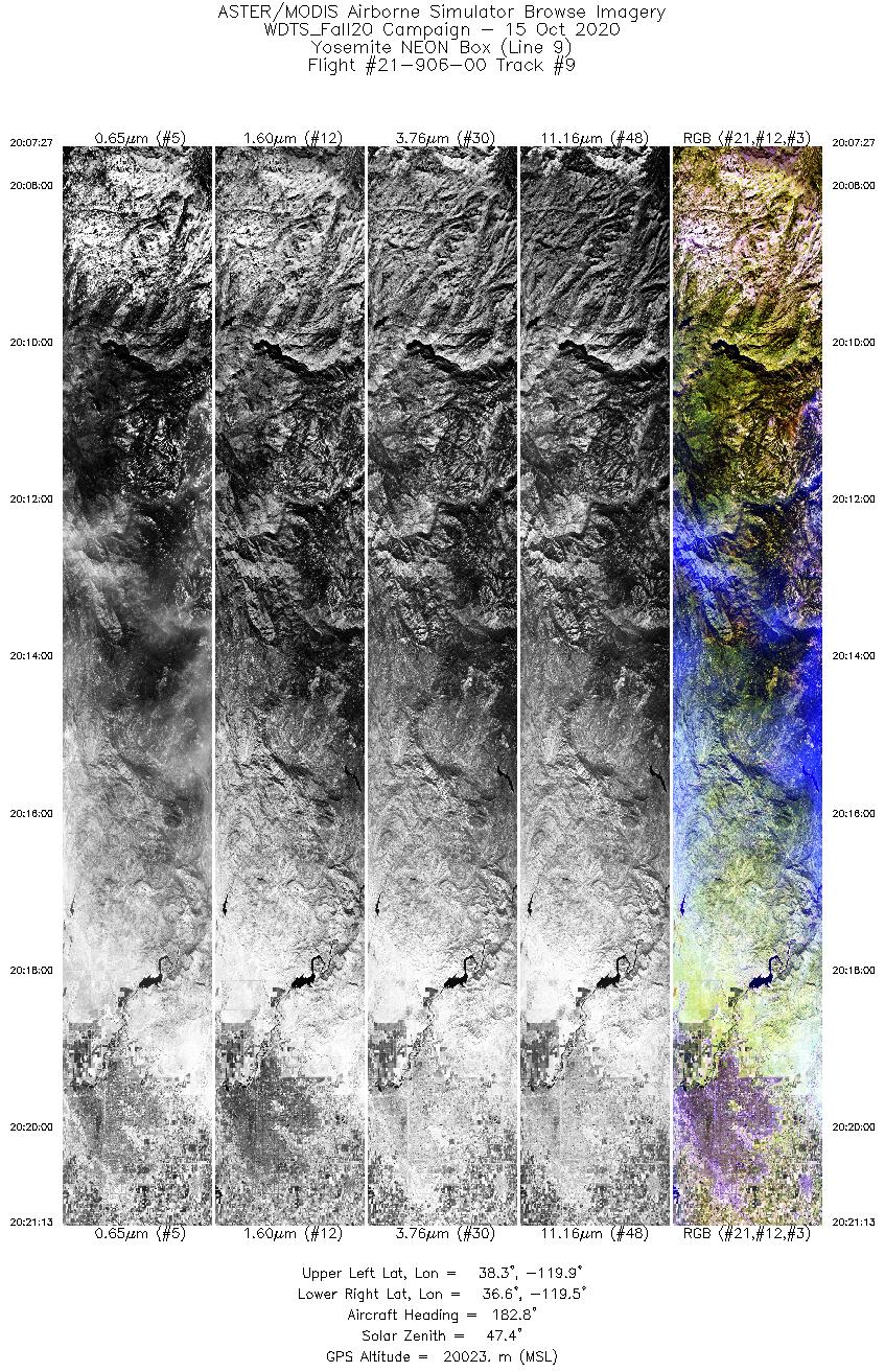
Federal
MASTER: Western Diversity Time Series Campaign, WDTS, California, USA, Fall 2020
National Aeronautics and Space Administration —
This dataset includes Level 1B (L1B) and Level 2 (L2) data products from the MODIS/ASTER Airborne Simulator (MASTER) instrument. The spectral data were collected as... -
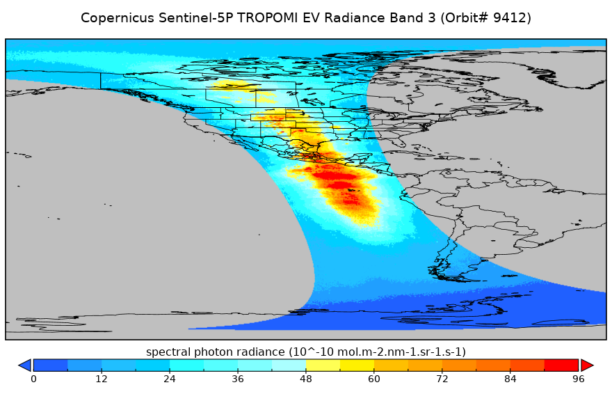
Federal
Sentinel-5P TROPOMI Near-Real-Time (NRT) Radiance product band 3 (UVIS detector) L1B 5.5km x 3.5km V2 (S5P_L1B_RA_BD3_HiR_NRT) at GES DISC
National Aeronautics and Space Administration —
The Sentinel-5P TROPOMI Near Real Time (NRT) Radiance product band 3 (UVIS detector) L1B 5.5km x 21km V2 (S5P_L1B_RA_BD3_HiR_NRT_NRT) product at GES DISC is the near... -
Federal
SMEX03 Landsat Thematic Mapper Imagery: Georgia, Version 1
National Aeronautics and Space Administration —
This data set provides imagery developed from Landsat 5 Thematic Mapper (TM) data for use in studying land cover features during the Soil Moisture Experiment 2003... -
Federal
ACRIM III Level 2 Shutter Cycle Data V001
National Aeronautics and Space Administration —
ACR3L2SC_1 is the Active Cavity Radiometer Irradiance Monitor (ACRIM) III Level 2 Shutter Cycle Data version 1 product contains Level 2 total solar irradiance in the... -
Federal
SAFARI 2000 LAI and FPAR Measurements at Sua Pan, Botswana, Dry Season 2000
National Aeronautics and Space Administration —
The Multi-angle Imaging SpectroRadiometer (MISR) Validation team was deployed to the Sua Pan salt playa in the Magkadigkadi region of Botswana during the SAFARI 2000... -
Federal
Reduced-Resolution QuickBird Imagery and Related GIS Layers for Barrow, Alaska, USA, Version 1
National Aeronautics and Space Administration —
This data set contains reduced-resolution QuickBird imagery and geospatial data for the entire Barrow QuickBird image area 156.15° W - 157.07° W, 71.15° N - 71.41° N)...

Official websites use .gov
A
.gov website belongs to an official government
organization in the United States.
Secure .gov websites use HTTPS
A
lock (
) or https:// means you’ve safely connected to
the .gov website. Share sensitive information only on official,
secure websites.