
-
Federal
Unoccupied Aerial System-mounted image velocimetry and Doppler velocity radar data for computation of river velocity and discharge collected at seven locations in Colorado in 2023: Radar Spectra
Department of the Interior —
This child item contains Doppler radar velocimetry spectra measurements for each field site where the radars were deployed. Each field site is abbreviated in various... -
Federal
Unoccupied Aerial System-mounted image velocimetry and Doppler velocity radar data for computation of river velocity and discharge collected at seven locations in Colorado in 2023: Cross-Section Geometry
Department of the Interior —
This child item contains bathymetric measurements of the channel geometry suitable for use in computing cross-sectional area for each field site. Each field site is... -
Federal
Shorelines Derived from Continuous Video-Imagery at the NASA-Kennedy Space Center, Florida From August 2011 to July 2012
Department of the Interior —
In 2010, a video camera was installed near the northern boundary of the National Aeronautics and Space Administration-Kennedy Space Center (NASA-KSC) property along... -
Federal
Video transects of the sea floor on Stellwagen Bank during U.S. Geological Survey field activity 2019-008-FA, aboard the R/V Auk, July 30, 31, and August 1, 2019
Department of the Interior —
This field activity is part of the effort to map geologic substrates of the Stellwagen Bank National Marine Sanctuary region off Boston, Massachusetts. The overall... -
Federal
Location of bottom video tracklines along with videos collected in July 2016 by the U.S. Geological Survey off Town Neck Beach in Sandwich, Massachusetts, during field activity 2016-037-FA (MP4 video files and polyline shapefile)
Department of the Interior —
Geophysical and geological survey data were collected off Town Neck Beach in Sandwich, Massachusetts, in May and July 2016. Approximately 130 linear kilometers of... -
Federal
Sea-floor videos and locations of bottom video tracklines collected in Cape Cod Bay, Massachusetts, in September 2019 by the U.S. Geological Survey during field activity 2019-034-FA (MP4 video files and polyline shapefile, GCS WGS 84)
Department of the Interior —
Accurate data and maps of sea floor geology are important first steps toward protecting fish habitat, delineating marine resources, and assessing environmental... -
Federal
CRED Integrated Benthic Habitat Map for French Frigate Shoals, Northwestern Hawaiian Islands 2007
National Oceanic and Atmospheric Administration, Department of Commerce —
This is an integrated benthic habitat map system which consists of a number of separate map layers including multibeam bathymetry, acoustic backscatter imagery,... -
Federal
CRED Optical Validation Data at the island of Ta'u in American Samoa, 2006 to support Benthic Habitat Mapping (TOAD)
National Oceanic and Atmospheric Administration, Department of Commerce —
Optical validation data were collected using a Tethered Optical Assessment Device (TOAD), an underwater sled equipped with an underwater digital video camera and... -
Federal
CRED Fish Biomass Estimates map at French Frigate Shoals, 2001-2008
National Oceanic and Atmospheric Administration, Department of Commerce —
This map displays fish biomass observation locations overlaid on bathymetry -
Federal
CRED Optical Validation Data at the island of Ofu and Olosega in American Samoa, 2006 to support Benthic Habitat Mapping (TOAD)
National Oceanic and Atmospheric Administration, Department of Commerce —
Optical validation data were collected using a Tethered Optical Assessment Device (TOAD), an underwater sled equipped with an underwater digital video camera and... -
Federal
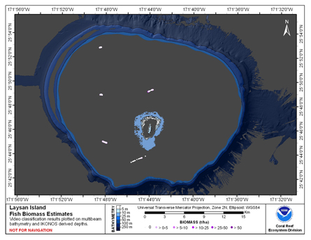
CRED Fish Biomass Estimates map at Laysan Island
National Oceanic and Atmospheric Administration, Department of Commerce —
This map displays fish biomass observation locations overlaid on bathymetry -
Federal
Benthic Habitats of Buck Island Reef National Monument, St. Croix U.S. Virgin Islands, 2004-02-18 to 2011-08-30 (NCEI Accession 0285904)
National Oceanic and Atmospheric Administration, Department of Commerce —
This data package contains information about the geology and biology of the seafloor from approximately 0 to 1,830 meters in Buck Island Reef National Monument... -
Federal
Unoccupied Aerial System-mounted image velocimetry and Doppler velocity radar data for computation of river velocity and discharge collected at seven locations in Colorado in 2023: Discharge Measurements
Department of the Interior —
This child item contains the raw acoustic Doppler velocity profiler (ADCP) measurements collected by U.S. Geological Survey (USGS) hydrographers at each site to... -
Federal
Discharge Measurements
Department of the Interior —
This child item contains the raw acoustic Doppler velocity profiler (ADCP) and acoustic Doppler velocimeter (ADV) measurements collected by U.S. Geological... -
Federal
Unoccupied Aerial System-mounted image velocimetry and Doppler velocity radar data for computation of river velocity and discharge collected at seven locations in Colorado in 2023: Ancillary Scripts
Department of the Interior —
This child item contains Microsoft Windows batch and Python script files that reproduce the processing steps for specific files associated with image calibration,... -
Federal
Unoccupied Aerial System-mounted image velocimetry and Doppler velocity radar data for computation of river velocity and discharge collected at seven locations in Colorado in 2023
Department of the Interior —
A series of field measurements of surface water velocity derived from video and Doppler velocity radar collected by small unoccupied aircraft systems (sUAS) and... -
Federal
Video transects of the sea floor on Stellwagen Bank during U.S. Geological Survey field activity 2016-004-FA, aboard the R/V Auk, January 28, 2016
Department of the Interior —
This field activity is part of the effort to map geologic substrates of the Stellwagen Bank National Marine Sanctuary region off Boston, Massachusetts. The overall... -
Federal
Calibration Images
Department of the Interior —
This child item contains images associated with each field site annotated with labeled calibration marks and associated pixel locations for each dataset. The images... -
Federal
Long-Term Monitoring at the East and West Flower Garden Banks National Marine Sanctuary 2002-2006, (NODC Accession 0012632)
National Oceanic and Atmospheric Administration, Department of Commerce —
The Long-Term Monitoring at the East and West Flower Garden Banks National Marine Sanctuary 2002-2006 data include biological and oceanographic measurements collected... -
Federal
Particle Image Velocimetry Images
Department of the Interior —
This child item contains the image frames extracted from videos for each field site. The images serve as the input to the Particle Image Velocimetry (PIV) analysis....

Official websites use .gov
A
.gov website belongs to an official government
organization in the United States.
Secure .gov websites use HTTPS
A
lock (
) or https:// means you’ve safely connected to
the .gov website. Share sensitive information only on official,
secure websites.