

404 datasets found
-
Federal
Soil erosion and organic matter for central Great Plains cropping systems under residue removal
Department of Agriculture —
This study examined average annual changes in soil erosion from rainfall and wind forces, and trends in soil organic carbon (SOC). The diversity of geo-climatic land... -
City
CTA - Ridership - Bus Routes - Daily Totals by Route
City of Chicago —
This dataset shows total daily ridership on a per-route basis dating back to 2001. Daytypes are as follows: W=Weekday, A=Saturday, U=Sunday/Holiday. See attached... -
Federal
Simplified two and fifty-one region state-based EEIO model comparison
U.S. Environmental Protection Agency —
Supporting data for 2 region and 51 region models assessed in the manuscript "Exploring the relevance of spatial scale to life cycle inventory results using... -
County
Municipal Building Energy Usage
Allegheny County / City of Pittsburgh / Western PA Regional Data Center —
This data set contains energy use data from 2009-2014 for 139 municipally operated buildings. Metrics include: Site & Source EUI, annual electricity, natural gas... -
City
CTA - System Information - Developer Tool: GTFS Data
City of Chicago —
General Transit Feed Specification (formerly "Google Transit Feed Specification") data package for CTA system, including stops, route patterns and full service schedule. -
City
OneNYC 2050 (Historical)
City of New York —
This dataset contains the indicators included in the OneNYC 2050 Strategic Plan that will be used to assess progress in achieving the eight overreaching goals of the... -
Federal
USEEIO Satellite Files
U.S. Environmental Protection Agency —
These files contain the environmental data as particular emissions or resources associated with a BEA sectors that are used in the USEEIO model. They are organized by... -
City
CTA - Bus Stops - Shapefile
City of Chicago —
Point data representing locations of CTA bus stops. See attachment below for information on STATUS and POS fields To view or use these files, compression software and... -
City
Green Roofs - Shapefile
City of Chicago —
This map and corresponding dataset provide the location, satellite images and square footage of existing green roofs within the City of Chicago. This dataset is in... -
City
Parks - Facilities & Features - KML (deprecated November 2016)
City of Chicago —
Facilities and features in Chicago parks. For more information, visit http://www.chicagoparkdistrict.com/facilities/search/. To view or use this KMZ file, compression... -
Federal
Compendium of Environmental Sustainability Indicator Collections: Complete Collection, Version 1.1
National Aeronautics and Space Administration —
The Compendium of Environmental Sustainability Indicator Collections, Version 1.1 contains 426 indicators for 239 countries from five major environmental... -
Federal
Sustainable Materials Management (SMM) Federal Green Challenge (FGC) Data
U.S. Environmental Protection Agency —
The Federal Green Challenge (FGC) is a national effort under EPA's Sustainable Materials Management (SMM) Program, challenging EPA and other federal agencies... -
City
CTA - System Information - List of 'L' Stops
City of Chicago —
This list of 'L' stops provides location and basic service availability information for each place on the CTA system where a train stops, along with formal station... -
City
San Francisco Communitywide Greenhouse Gas Inventory
City of San Francisco —
The purpose of the San Francisco Communitywide Greenhouse Gas Inventory is to measure and track greenhouse gas emissions to determine progress towards meeting the... -
Federal
National Greenhouse Gas Industry Attribution Model
U.S. Environmental Protection Agency —
The National Greenhouse Gas Industry Attribution Model is dynamic model that attributes US Greenhouse Gas (GHG) emissions as reported in the US GHG Inventory [1] to... -
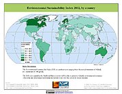
Federal
2002 Environmental Sustainability Index (ESI)
National Aeronautics and Space Administration —
The 2002 Environmental Sustainability Index (ESI) measures overall progress toward environmental sustainability for 142 countries based on environmental systems,... -
Federal
EnviroAtlas - 2002 Edge-of-Field Simulated Nitrogen, Phosphorus and Water Quantity Loss by 12-digit HUC for the Conterminous United States
U.S. Environmental Protection Agency —
This EnviroAtlas dataset contains annual (2002) simulated estimations of edge-of-field agricultural nitrogen (N) and phosphorus (P) lost in surface runoff, subsurface... -
City
Metra Lines
City of Chicago —
Metra commuter rail lines in the Chicagoland region. To view or use these files, compression software and special GIS software, such as ESRI ArcGIS, is required. To...
404 datasets found