

77 datasets found
-
Federal
TIGER/Line Shapefile, Current, County, Newberry County, SC, Topological Faces (Polygons With All Geocodes)
U.S. Census Bureau, Department of Commerce —
The TIGER/Line shapefiles and related database files (.dbf) are an extract of selected geographic and cartographic information from the U.S. Census Bureau's Master... -
Federal
TIGER/Line Shapefile, Current, County, Newberry County, SC, Address Range-Feature
U.S. Census Bureau, Department of Commerce —
The TIGER/Line shapefiles and related database files (.dbf) are an extract of selected geographic and cartographic information from the U.S. Census Bureau's Master... -
Federal
A Thermal-Hydrological-Chemical Model for the EGS Demonstration Project at Newberry Volcano, OR
Department of Energy —
Newberry Volcano in Central Oregon is the site of a Department of Energy funded Enhanced Geothermal System (EGS) Demonstration Project. Stimulation and production of... -
Federal
Validation of Innovative Exploration Technologies for Newberry Volcano: Geochemistry Data from Wells 55-29 and 46-16
Department of Energy —
Validation of Innovative Exploration Technologies for Newberry Volcano: DOE Geochemistry data from deep wells 55-29 and 46-16 at Newberry 2012 -
Federal
Preliminary Analysis of Stress in the Newberry EGS Well NWG 55-29
Department of Energy —
As part of the planning for stimulation of the Newberry Volcano Enhanced Geothermal Systems (EGS) Demonstration project in Oregon, a high-resolution borehole... -
Federal
Establishing the Frontier Observatory for Research in Geothermal Energy (FORGE) on the Newberry Volcano, OR
Department of Energy —
The proposed Newberry Volcano FORGE site is in central Oregon on the northwest flank of the largest volcano in the Cascades volcanic arc. Beneath Newberry Volcano is... -
Federal
Newberry FORGE: 3D Gravity Density Model for Newberry Volcano
Department of Energy —
These data are Pacific Northwest National Lab inversions of an amalgamation of two surface gravity datasets: Davenport-Newberry gravity collected prior to 2012... -
Federal
Newberry EGS Well Logs, Earthquakes, Maps, Cross-Sections, and LiDAR Datasets
Department of Energy —
Datasets and information used to characterize the subsurface of Newberry and support modeling efforts. Includes sources for well logs, earthquakes, maps & cross-... -
Federal
Newberry EGS Literature References
Department of Energy —
Research references to literature about the Newberry geothermal area, Oregon. -
Federal
Validation of Innovative Exploration Technologies for Newberry Volcano: LiDAR of Newberry Volcano
Department of Energy —
Validation of Innovative Exploration Technologies for Newberry Volcano: LiDAR of Newberry Volcano 2012 -
Federal
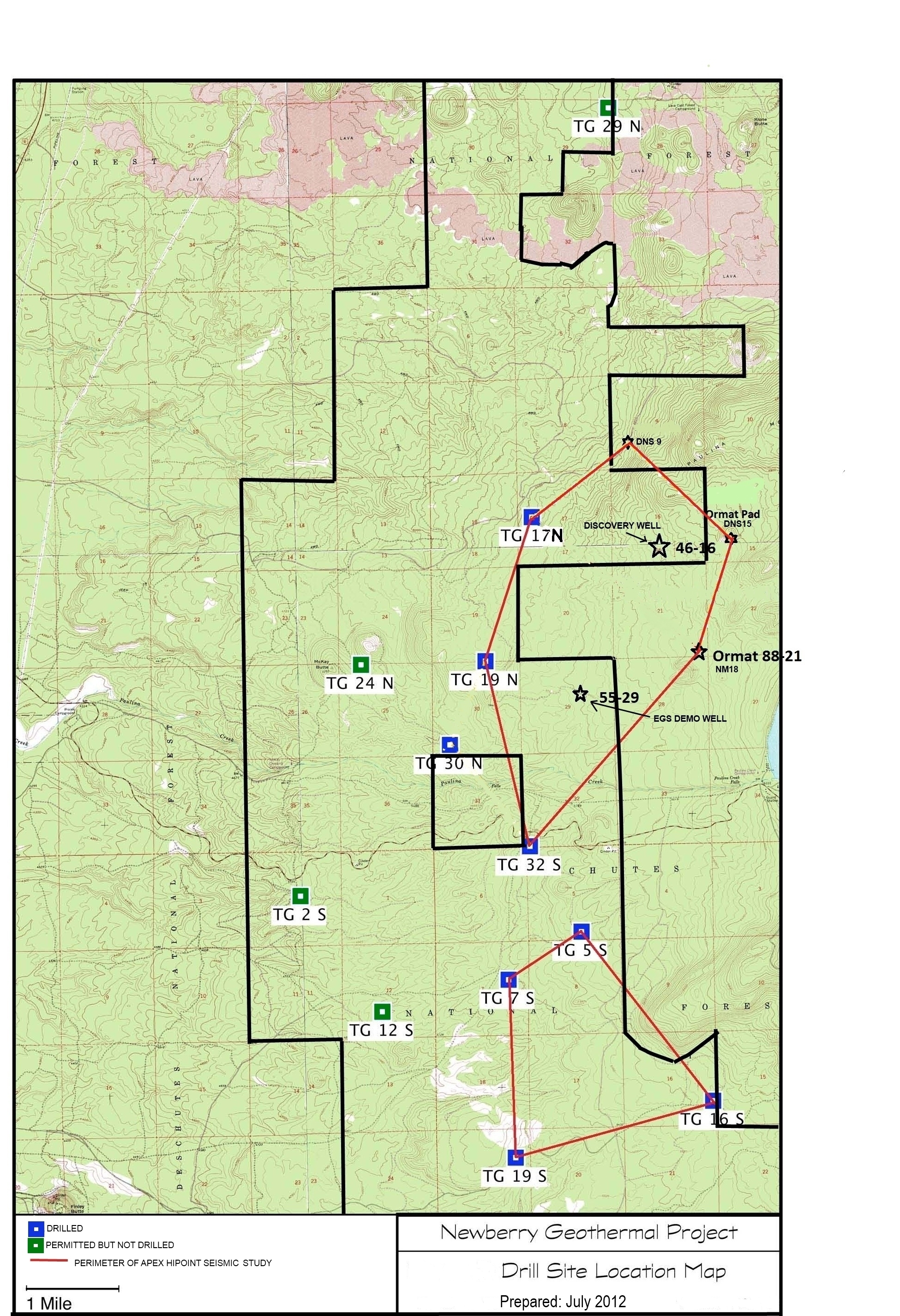
Map of Validation of Innovative Exploration Technologies for Newberry Volcano
Department of Energy —
A map showing location of wells permitted, drilled and seismic test, as part of validation of innovative exploration technologies done for the Newberry Volcano... -
Federal
Validation of Innovative Exploration Technologies for Newberry Volcano: Gravity Report
Department of Energy —
Report detailing data acquisition, quality, processing, and presentation for the gravity survey conducted on the Newberry Volcano. (Validation of Innovative... -
Federal
Validation of Innovative Exploration Technologies for Newberry Volcano: Raw Gravity Data
Department of Energy —
Validation of Innovative Exploration Technologies for Newberry Volcano: Raw data used to prepare the Gravity Report by Zonge 2012 -
Federal
Potential Wetland Extent Along the White River Between USGS Gaging Stations 03357000 and 03374100
Department of the Interior —
The Wetland Reserve Program (WRP) is a voluntary program administered by the NRCS. It provides technical and financial assistance to private landowners and Tribes to... -
Federal
TIGER/Line Shapefile, 2022, County, Newberry County, SC, Topological Faces (Polygons With All Geocodes)
U.S. Census Bureau, Department of Commerce —
The TIGER/Line shapefiles and related database files (.dbf) are an extract of selected geographic and cartographic information from the U.S. Census Bureau's Master... -
Federal
Newberry Caldera Conceptual Geophysical Model
Department of Energy —
Conceptual model for the Newberry Caldera geothermal area. Model is centered around caldera and evaluates multiple geophysical datasets to derive a conceptual... -
Federal
TIGER/Line Shapefile, Current, County, Newberry County, SC, All Lines
U.S. Census Bureau, Department of Commerce —
The TIGER/Line shapefiles and related database files (.dbf) are an extract of selected geographic and cartographic information from the U.S. Census Bureau's Master... -
Federal
TIGER/Line Shapefile, Current, County, Newberry County, SC, Linear Hydrography
U.S. Census Bureau, Department of Commerce —
The TIGER/Line shapefiles and related database files (.dbf) are an extract of selected geographic and cartographic information from the U.S. Census Bureau's Master... -
Federal
A Conceptual Geologic Model for the Newberry Volcano EGS Site in Central Oregon: Constraining Heat Capacity and Permeability through Interpretation of Multicomponent Geosystems Data
Department of Energy —
Newberry Volcano, a voluminous (500 km3) basaltic/andesitic/rhyolitic shield volcano located near the intersection of the Cascade volcanic arc, the Oregon High Lava... -
Federal
TIGER/Line Shapefile, 2022, County, Newberry County, SC, Feature Names Relationship File
U.S. Census Bureau, Department of Commerce —
The TIGER/Line shapefiles and related database files (.dbf) are an extract of selected geographic and cartographic information from the U.S. Census Bureau's Master...
77 datasets found