
-
Federal
CRED REA Fish Team Belt Transect Surveys at Kure Atoll 2004
National Oceanic and Atmospheric Administration, Department of Commerce —
Belt transects along 3 consecutively-placed, 25m transect lines were surveyed as part of Rapid Ecological Assessments conducted at 9 sites at Kure Atoll in October,... -
Federal
CRED REA Fish Team Belt Transect Survey at Laysan 2004
National Oceanic and Atmospheric Administration, Department of Commerce —
Belt transects along 3 consecutively-placed, 25m transect lines were surveyed as part of Rapid Ecological Assessments conducted at 3 sites at Laysan in the Northwest... -
Federal
CRED Towed-Diver Fish Biomass Surveys at Pearl And Hermes Atoll, NW Hawaiian Islands in 2004
National Oceanic and Atmospheric Administration, Department of Commerce —
Towed-diver surveys (aka. Towboard surveys) are conducted by the Coral Reef Ecosystem Division (CRED) of the NOAA Pacific Islands Fisheries Science Center (PIFSC) as... -
Federal
CRED REA Coral Health and Disease Assessment at Gardner Pinnacles, Northwestern Hawaiian Islands, 2004
National Oceanic and Atmospheric Administration, Department of Commerce —
One, 25-m line transect was surveyed at 50-cm intervals as part of the Rapid Ecological Assessment conducted at 3 sites at Gardner Pinnacles in the Northwestern... -
Federal
CRED Shallow CTD Profiles; Midway Atoll, Northwestern Hawaiian Islands (Papahanaumokuakea Marine National Monument); Cruise: HI0401, Data Date Range: 20041001-20041004 (NODC Accession 0039382).
National Oceanic and Atmospheric Administration, Department of Commerce —
CRED shallow Conductivity-Temperature-Depth (CTD) casts are vertical profiles (max 30 meter depth, downcast only) of temperature, conductivity and pressure. Data are... -
Federal
CRED REA Coral Health and Disease Assessment at Lisianski Island, Northwestern Hawaiian Islands, 2004
National Oceanic and Atmospheric Administration, Department of Commerce —
One, 25-m line transect was surveyed at 50-cm intervals as part of the Rapid Ecological Assessment conducted at 9 sites at Lisianski Island in the Northwestern... -
Federal
CRED REA Fish Team Belt Transect Surveys at Lisianski Island, 2004
National Oceanic and Atmospheric Administration, Department of Commerce —
Belt transects along 3 consecutively-placed, 25m transect lines were surveyed as part of Rapid Ecological Assessments conducted at 9 sites at Lisianski in October,... -
Federal
CRED Towed-Diver Fish Biomass Surveys at Gardner Pinnacles, NW Hawaiian Islands in 2004
National Oceanic and Atmospheric Administration, Department of Commerce —
Towed-diver surveys (aka. Towboard surveys) are conducted by the Coral Reef Ecosystem Division (CRED) of the NOAA Pacific Islands Fisheries Science Center (PIFSC) as... -
Federal
CRED REA Coral Health and Disease Assessment at Midway Atoll, Northwestern Hawaiian Islands, 2004
National Oceanic and Atmospheric Administration, Department of Commerce —
One, 25-m line transect was surveyed at 50-cm intervals as part of the Rapid Ecological Assessment conducted at 9 sites at Midway Atoll in the Northwestern Hawaiian... -
Federal
CRED REA Invertebrate Quantitative Assessments at Lisianski Island, NW Hawaiian Islands, in 2004
National Oceanic and Atmospheric Administration, Department of Commerce —
To support a long-term NOAA Coral Reef Conservation Program (CRCP) for sustainable management and conservation of coral reef ecosystems, from 13 September - 17... -
Federal
CRED Shallow CTD Profiles; French Frigate Shoals, Northwestern Hawaiian Islands (Papahanaumokuakea Marine National Monument); Cruise: HI0401, Data Date Range: 20040917-20040919 (NODC Accession 0039382).
National Oceanic and Atmospheric Administration, Department of Commerce —
CRED shallow Conductivity-Temperature-Depth (CTD) casts are vertical profiles (max 30 meter depth, downcast only) of temperature, conductivity and pressure. Data are... -
Federal
CRED REA Coral Health and Disease Assessment at French Frigate Shoals, Northwestern Hawaiian Islands, 2004
National Oceanic and Atmospheric Administration, Department of Commerce —
One, 25-m line transect was surveyed at 50-cm intervals as part of the Rapid Ecological Assessment conducted at 11 sites at French Frigate Shoals in the Northwestern... -
Federal
CRED REA Fish Team Stationary Point Count Surveys at French Frigate Shoals, 2004
National Oceanic and Atmospheric Administration, Department of Commerce —
Stationary Point Counts at 4 stations at each survey site were surveyed as part of Rapid Ecological Assessments conducted at 9 sites at French Frigate Shoals in... -
Federal
CRED Cumulative Map of Percent Scleractinian Coral Cover at Maro Reef, 2001-2004
National Oceanic and Atmospheric Administration, Department of Commerce —
This map displays optical validation observation locations and percent coverage of scleractinian coral overlaid on bathymetry. -
Federal
CRED REA Fish Team Stationary Point Count Surveys at Maro Reef, 2004
National Oceanic and Atmospheric Administration, Department of Commerce —
Stationary Point Counts at 4 stations at each survey site were surveyed as part of Rapid Ecological Assessments conducted at 9 sites at Maro Reef, in September, 2004... -
Federal
CRED Cumulative Map of Percent Scleractinian Coral Cover at Kure Atoll, 2002-2004
National Oceanic and Atmospheric Administration, Department of Commerce —
This map displays optical validation observation locations and percent coverage of scleractinian coral overlaid on bathymetry. -
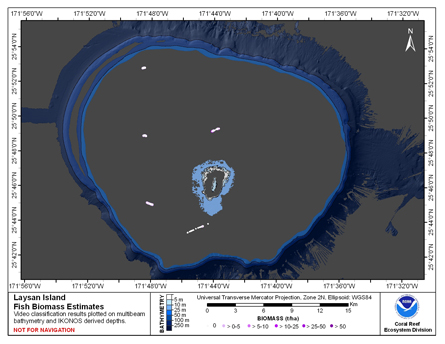
Federal
CRED Fish Biomass Estimates map at Laysan Island
National Oceanic and Atmospheric Administration, Department of Commerce —
This map displays fish biomass observation locations overlaid on bathymetry -
Federal
CRED Cumulative Map of Percent Scleractinian Coral Cover at Midway Atoll, 2002-04
National Oceanic and Atmospheric Administration, Department of Commerce —
This map displays optical validation observation locations and percent coverage of scleractinian coral overlaid on bathymetry. -
Federal
CRED Cumulative Map of Percent Scleractinian Coral Cover at Laysan Island, 2002-2004
National Oceanic and Atmospheric Administration, Department of Commerce —
This map displays optical validation observation locations and percent coverage of scleractinian coral overlaid on bathymetry. -
Federal
CRED Cumulative Map of Percent Scleractinian Coral Cover at Pearl and Hermes Atoll, 2002-2004
National Oceanic and Atmospheric Administration, Department of Commerce —
This map displays optical validation observation locations and percent coverage of scleractinian coral overlaid on bathymetry.

Official websites use .gov
A
.gov website belongs to an official government
organization in the United States.
Secure .gov websites use HTTPS
A
lock (
) or https:// means you’ve safely connected to
the .gov website. Share sensitive information only on official,
secure websites.