
-
Federal
Dissolved inorganic carbon, total alkalinity, pH on Total Scale, nutrients and other variables collected from profile and discrete sample observations using CTD, Niskin bottle and other instruments on board NOAA Ship Henry B. Bigelow in the Gulf of Maine, Georges Bank, and Mid-Atlantic Bight from 2018-05-23 to 2018-06-04 (NCEI Accession 0183469) recent views
National Oceanic and Atmospheric Administration, Department of Commerce —
This dataset contains dissolved inorganic carbon, Total alkalinity, pH on Total Scale, nutrients and other variables measured from profile discrete measurement in the... -
Federal
Dissolved inorganic carbon, total alkalinity, pH, and other variables collected from profile and discrete sample observations using CTD, Niskin bottle, and other instruments from NOAA Ship Henry B. Bigelow off the Northeastern coast of the United States from 2012-06-02 to 2012-06-13 (NCEI Accession 0138982) recent views
National Oceanic and Atmospheric Administration, Department of Commerce —
This dataset contains discrete bottle (CTD profile) data that were collected off the Northeastern coast of the United States in 2012. Increasing amounts of... -
Federal
Dissolved inorganic carbon, total alkalinity, pH, and other variables collected from profile and discrete sample observations using CTD, Niskin bottle, and other instruments from NOAA Ship Pisces off the northeastern coast of the United States from 2012-10-26 to 2012-11-14 (NCEI Accession 0137874) recent views
National Oceanic and Atmospheric Administration, Department of Commerce —
This dataset contains discrete bottle (CTD profile) data that were collected off the Northeastern coast of the United States in 2012. Increasing amounts of... -
Federal
Surface measurements of partial pressure of CO2 (pCO2), pH on total scale, water temperature, salinity, and other variables in the Casco Bay, Gulf of Maine from 2015-04-23 to 2020-06-12 (NCEI Accession 0229832) recent views
National Oceanic and Atmospheric Administration, Department of Commerce —
This dataset consists of surface measurements of partial pressure of CO2 (pCO2), pH on total scale, water temperature, salinity, and other variables in the Casco Bay,... -
Federal
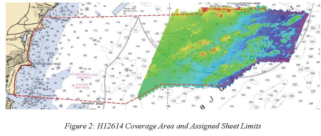
H12614: NOS Hydrographic Survey , Approaches to Portsmouth, NH, 2013-09-13 recent views
National Oceanic and Atmospheric Administration, Department of Commerce —
The National Oceanic and Atmospheric Administration (NOAA) has the statutory mandate to collect hydrographic data in support of nautical chart compilation for safe... -
Federal
Estuarine Living Marine Resources: North Atlantic Regional Distribution and Abundance (NCEI Accession 0162402) recent views
National Oceanic and Atmospheric Administration, Department of Commerce —
This is the North Atlantic regional component of NOAAâs Estuarine Living Marine Resources (ELMR) Project, a national database of ecologically and economically... -
Federal
W00590: NOS Hydrographic Survey , 2020-08-20 recent views
National Oceanic and Atmospheric Administration, Department of Commerce —
The National Oceanic and Atmospheric Administration (NOAA) has the statutory mandate to collect hydrographic data in support of nautical chart compilation for safe... -
Federal
W00533: NOS Hydrographic Survey , 2012-12-31 recent views
National Oceanic and Atmospheric Administration, Department of Commerce —
The National Oceanic and Atmospheric Administration (NOAA) has the statutory mandate to collect hydrographic data in support of nautical chart compilation for safe... -
Federal
U.S. Geological Survey Oceanographic Time-Series Data Collection of measurements of current velocity, temperature, pressure and other data made in U.S. coastal waters between 1975 and present recent views
National Oceanic and Atmospheric Administration, Department of Commerce —
This collection includes time-series oceanographic data collected by U.S. Geological Survey investigators and collaborators as part of experiments to study... -
Federal
Assessment of Existing Information for Atlantic Coastal Fish Habitat Partnership (ACFHP) recent views
National Oceanic and Atmospheric Administration, Department of Commerce —
The ACFHP database consist of three primary data tables, joined within SQL Server, a relational DBMS: 1. The Bibliographic table provides information on over 500... -
Federal
Gulf of Maine - Control Points Used to Validate the Accuracies of the Interpolated Water Density Rasters recent views
National Oceanic and Atmospheric Administration, Department of Commerce —
This feature dataset contains the control points used to validate the accuracies of the interpolated water density rasters for the Gulf of Maine. These control points... -
Federal
Grand Composite Raster Images for Sea Surface Temperature in the Gulf of Maine for Stellwagen Bank NMS recent views
National Oceanic and Atmospheric Administration, Department of Commerce —
This personal geodatabase contains raster images of sea surface temperature (SST) in the Gulf of Maine. These raster images are a composite of several years... -
Federal
Gulf of Maine Cooperative Bottom Longline Survey Database recent views
National Oceanic and Atmospheric Administration, Department of Commerce —
This database is for a bottom longline (fixed gear) survey executed in the western and central Gulf of Maine targeting complex rocky habitats. The survey is operated... -
Federal
IVR EFP Database recent views
National Oceanic and Atmospheric Administration, Department of Commerce —
This database contains trip-level reports submitted by vessels participating in Exempted Fishery projects with IVR reporting requirements. -
Federal
GARFOGIS_DATA_TRACKING.xlsm recent views
National Oceanic and Atmospheric Administration, Department of Commerce —
This spreadsheet is the central tracking document and inventory of "official" GIS datasets in development, published, or archived at the Greater Atlantic Regional... -
Federal
Northeast Cooperative Research Study Fleet (SF) Program Combined GPS, Temperature/Depth, and Effort Fishery Dependent Data recent views
National Oceanic and Atmospheric Administration, Department of Commerce —
Temperature, depth(TD), GPS and haul by haul effort and catch data are collected during normal fishing activity of commercial fishing vessels participating in the... -
Federal
Gulf of Maine CMTS Calanus Abundance Observations, since 2020 recent views
National Oceanic and Atmospheric Administration, Department of Commerce —
Coastal Maine Time Series Station (CMTS) -
Federal
OBSCAN Observer Scanning System recent views
National Oceanic and Atmospheric Administration, Department of Commerce —
Paper logs are the primary data collection tool used by observers of the Northeast Fisheries Observer Program deployed on commercial fishing vessels. After the data... -
Federal
Gulf of Maine - Water Salinity, Temperature and Sigma t (density) data from 1981 to 2005 recent views
National Oceanic and Atmospheric Administration, Department of Commerce —
This table contains water salinity, temperature and sigma t (density) data from 1981 to 2005 binned at 10 meter depth intervals (from 300 meters up to 0 meters) for...

Official websites use .gov
A
.gov website belongs to an official government
organization in the United States.
Secure .gov websites use HTTPS
A
lock (
) or https:// means you’ve safely connected to
the .gov website. Share sensitive information only on official,
secure websites.