
-
Federal
Global Annual Freezing and Thawing Indices, Version 1 recent views
National Aeronautics and Space Administration —
The total annual freezing and thawing indices are defined as the cumulative number of degree-days when air temperatures are below and above zero degrees Celsius. The... -
Federal
TOMS/N7 MS SO2 Vertical Column 1-Orbit L2 Swath 50x50 km V3 (TOMSN7SO2) at GES DISC recent views
National Aeronautics and Space Administration —
Version 3 is the current version of the data set. Older versions will no longer be available and have been superseded by Version 3. The goal of this data set is to... -
Federal
GPM Ground Validation Environment Canada (EC) Weather Station XET C3VP V1 recent views
National Aeronautics and Space Administration —
The GPM Ground Validation Environment Canada (EC) Weather Station XET C3VP dataset consists of surface meteorological data collected at the Environment Canada (EC)... -
Federal
MERRA-2 statM_2d_edi_Nx: 2d, Single-Level, Monthly Extremes Detection Indices based on 1991-2020 V2 (M2SMNXEDI) at GES DISC recent views
National Aeronautics and Space Administration —
M2SMNXEDI (or statM_2d_edi_Nx) is a 2-dimensional monthly data collection for extreme detection indices derived from daily Modern-Era Retrospective analysis for... -
Federal
Randolph Glacier Inventory - A Dataset of Global Glacier Outlines, Version 3 NGDA recent views
National Aeronautics and Space Administration —
The Randolph Glacier Inventory (RGI) is a global set of glacier outlines; it is intended as a snapshot of the world’s glaciers. This data set provides a single... -
Federal
AMSR-E/Aqua Weekly L3 Global Ascending/Descending .25x.25 deg Ocean Grids V002 recent views
National Aeronautics and Space Administration —
The Level-3 daily product (AE_DyOcn), weekly product (AE_WkOcn), and monthly product (AE_MoOcn) include SST, near-surface wind speed, columnar water vapor, and... -
Federal
ABoVE: Lake Growing Season Green Surface Reflectance Trends, AK and Canada, 1984-2019 recent views
National Aeronautics and Space Administration —
This dataset provides an annual time series of Landsat green surface reflectance and the derived annual trend during the growing season (June and July) for 472,890... -
Federal
Randolph Glacier Inventory - A Dataset of Global Glacier Outlines, Version 2 NGDA recent views
National Aeronautics and Space Administration —
The Randolph Glacier Inventory (RGI) is a global set of glacier outlines; it is intended as a snapshot of the world’s glaciers. This data set provides a single... -
Federal
HOMAGE Monthly Time series of global average steric height anomalies and ocean heat content estimates from gridded in-situ ocean observations version 01 recent views
National Aeronautics and Space Administration —
The [HOMAGE_STERIC_OHC_TIME_SERIES_v01] dataset contains monthly global mean ocean heat content (OHC) anomalies as well as thermosteric, halosteric and total steric... -
Federal
ABoVE: Last Day of Spring Snow, Alaska, USA, and Yukon Territory, Canada, 2000-2016 NGDA recent views
National Aeronautics and Space Administration —
This dataset provides the last day of spring snow cover for most of Alaska and the Yukon Territory for 2000 through 2016. The data are based on the MODIS daily snow... -
Federal
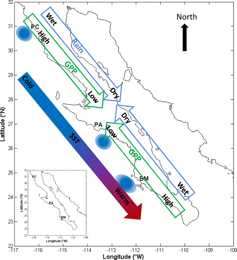
CMS: MODIS GPP, fPAR, and SST, and ENSO Index, Baja California, Mexico, 2000-2013 NGDA recent views
National Aeronautics and Space Administration —
This data set provides data for MODIS-derived (1) gross primary productivity (GPP) for the years 2000-2010, (2) fraction of photosynthetically active radiation (fPAR)... -
Federal
GPM Ground Validation Airborne Snow Observatory (ASO) OLYMPEX V1 recent views
National Aeronautics and Space Administration —
The GPM Ground Validation Airborne Snow Observatory (ASO) OLYMPEX dataset consists of snow depth, bare earth surface, land surface classification and a Red, Green,... -
Federal
ABoVE: Passive Microwave-derived Annual Snowoff Date Maps, 1988-2018 recent views
National Aeronautics and Space Administration —
This dataset provides annual maps of the snowoff (SO) date from 1988-2018 across Alaska and parts of Far East Russia and northwest Canada at a resolution of 6.25 km.... -
Federal
Groundswell Spatial Population and Migration Projections at One-Eighth Degree According to SSPs and RCPs, 2010-2050 recent views
National Aeronautics and Space Administration —
The Groundswell Spatial Population and Migration Projections at One-Eighth Degree According to SSPs and RCPs, 2010-2050, data set provides a baseline population... -
Federal
IceBridge Narrow Swath ATM L1B Elevation and Return Strength V002 recent views
National Aeronautics and Space Administration —
This data set contains spot elevation measurements of Greenland, Arctic, and Antarctic sea ice acquired using the NASA Airborne Topographic Mapper (ATM) narrow-swath... -
Federal
ICESat-2 L4 Monthly Gridded Sea Ice Thickness V003 recent views
National Aeronautics and Space Administration —
This data set reports monthly, gridded winter sea ice thickness across the Arctic Ocean. Sea ice thickness is estimated using ATLAS/ICESat-2 L3A Sea Ice Freeboard... -
Federal
Annual wildland fire emissions (WFEIS v0.5) for Conterminous US and Alaska, 2001-2013 NGDA recent views
National Aeronautics and Space Administration —
This data set contains annual modeled estimates of wildland fire emissions at 0.01 degree (~1-km) spatial resolution from the Wildland Fire Emissions Information... -
Federal
Nenana Ice Classic: Tanana River Ice Annual Breakup Dates, Version 2 recent views
National Aeronautics and Space Administration —
The Tanana river in the Interior of Alaska usually freezes over during October and November. The ice continues to grow throughout the winter accumulating an average... -
Federal
MEaSUREs ITS_LIVE Greenland Monthly 120 m Ice Sheet Extent Masks, 1972-2022 V001 recent views
National Aeronautics and Space Administration —
This ITS_LIVE data set, part of the Making Earth System Data Records for Use in Research Environments (MEaSUREs) Program, contains monthly, 120 m resolution ice masks... -
Federal
Soil Moisture Active Passive (SMAP) L1-L3 Ancillary GEOS Data V001 recent views
National Aeronautics and Space Administration —
This ancillary SMAP product contains three dynamic GMAO GEOS-5 modeled data sets. Each data set contains surface and atmospheric parameters pertinent to SMAP provided...

Official websites use .gov
A
.gov website belongs to an official government
organization in the United States.
Secure .gov websites use HTTPS
A
lock (
) or https:// means you’ve safely connected to
the .gov website. Share sensitive information only on official,
secure websites.