
-
Federal
Wind Turbine Sound Setbacks and Supply Curves: Ordinances and Extrapolated Trends, 110 Hub Height, 130 Rotor Diameter
Department of Energy —
This dataset provides a comprehensive set of wind turbine sound setbacks from every residential structure in the contiguous United States (CONUS). A sound setback is... -
Federal
NOAA/WDS Paleoclimatology - Saladyga fire data from Spring Mountain Central, Northeast Pennsylvania (Schuylkill County) - IMPD USSMC002
National Oceanic and Atmospheric Administration, Department of Commerce —
This archived Paleoclimatology Study is available from the NOAA National Centers for Environmental Information (NCEI), under the World Data Service (WDS) for... -
Federal
NOAA/WDS Paleoclimatology - Lawrence fire data from Waste House Run East, Northeast Pennsylvania (Schuylkill County) - IMPD USWHE001
National Oceanic and Atmospheric Administration, Department of Commerce —
This archived Paleoclimatology Study is available from the NOAA National Centers for Environmental Information (NCEI), under the World Data Service (WDS) for... -
Federal
NOAA/WDS Paleoclimatology - Saladyga fire data from Spring Mountain East, Northeast Pennsylvania (Schuylkill County) - IMPD USSME001
National Oceanic and Atmospheric Administration, Department of Commerce —
This archived Paleoclimatology Study is available from the NOAA National Centers for Environmental Information (NCEI), under the World Data Service (WDS) for... -
Federal
NOAA/WDS Paleoclimatology - Saladyga fire data from Spring Mountain West, Northeast Pennsylvania (Schuylkill County) - IMPD USSMW001
National Oceanic and Atmospheric Administration, Department of Commerce —
This archived Paleoclimatology Study is available from the NOAA National Centers for Environmental Information (NCEI), under the World Data Service (WDS) for... -
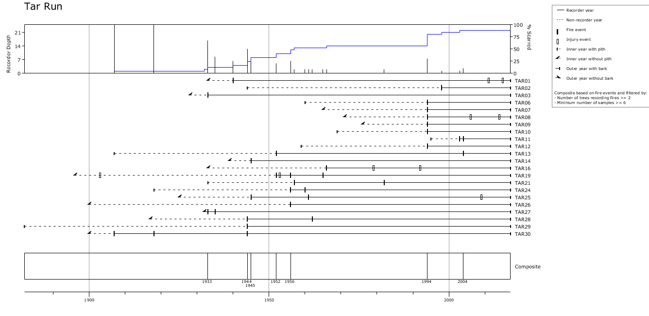
Federal
NOAA/WDS Paleoclimatology - Saladyga fire data from Tar Run, Northeast Pennsylvania (Schuylkill County) - IMPD USTAR001
National Oceanic and Atmospheric Administration, Department of Commerce —
This archived Paleoclimatology Study is available from the NOAA National Centers for Environmental Information (NCEI), under the World Data Service (WDS) for... -
Federal
NOAA/WDS Paleoclimatology - Saladyga fire data from Mill Creek, Northeast Pennsylvania (Schuylkill County) - IMPD USMIL001
National Oceanic and Atmospheric Administration, Department of Commerce —
This archived Paleoclimatology Study is available from the NOAA National Centers for Environmental Information (NCEI), under the World Data Service (WDS) for... -
Federal
NOAA/WDS Paleoclimatology - Saladyga fire data from Abandoned Road, Northeast Pennsylvania (Schuylkill County) - IMPD USARD001
National Oceanic and Atmospheric Administration, Department of Commerce —
This archived Paleoclimatology Study is available from the NOAA National Centers for Environmental Information (NCEI), under the World Data Service (WDS) for... -
Federal
Risk Factor Analysis in Low-Temperature Geothermal Play Fairway Analysis for the Appalachian Basin (GPFA-AB)
Department of Energy —
This submission contains information used to compute the risk factors for the GPFA-AB project. The risk factors are natural reservoir quality, thermal resource... -
Federal
Georgia Compact II - Industry-Led Skills and Workforce Development (TVET)
Millennium Challenge Corporation —
Georgia Compact II - Industry-Led Skills and Workforce Development (TVET) -
Federal
Global N Cycle: Fluxes and N2O Mixing Ratios Originating from Human Activity
National Aeronautics and Space Administration —
Nitrogen is a major nutrient in terrestrial ecosystems and an important catalyst in tropospheric photochemistry. Over the last century human activities have... -
Federal
NOAA/WDS Paleoclimatology - Saladyga fire data from Wolf Creek, Northeast Pennsylvania (Schuylkill County) - IMPD US WLF001
National Oceanic and Atmospheric Administration, Department of Commerce —
This archived Paleoclimatology Study is available from the NOAA National Centers for Environmental Information (NCEI), under the World Data Service (WDS) for... -
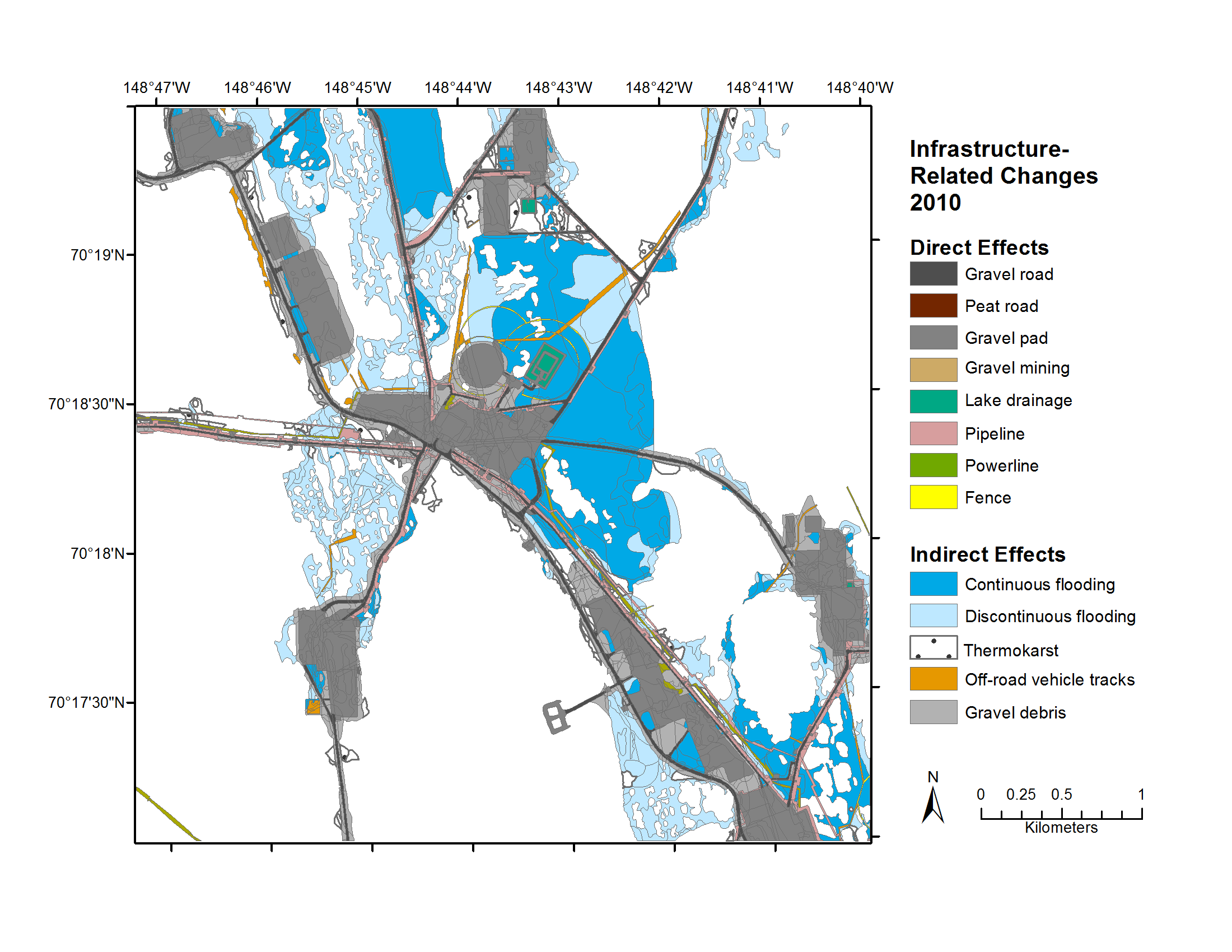
Federal
Geobotanical and Impact Map Collection for Prudhoe Bay Oilfield, Alaska, 1972-2010
National Aeronautics and Space Administration —
This data set provides a collection of maps of geoecological characteristics of areas within the Beechey Point quadrangle near Prudhoe Bay on the North slope of... -
Federal
Wind Turbine Sound Setbacks: Ordinances (2024) and Extrapolated Trends, 115 Hub Height, 170 Rotor Diameter
Department of Energy —
This dataset provides a comprehensive assessment of wind turbine sound setbacks for all residential structures across the contiguous United States (CONUS). A sound... -
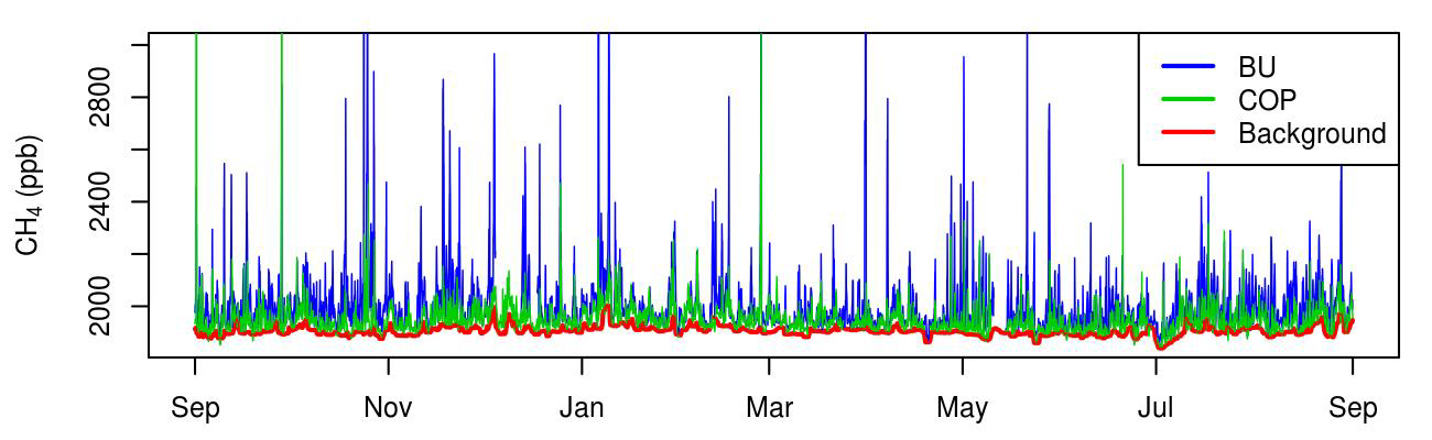
Federal
CMS: Atmospheric Methane Concentrations and Prior Emissions, Boston, MA, 2012-2014
National Aeronautics and Space Administration —
This data set provides average hourly measured, modeled enhancements, and background methane (CH4) concentrations, atmospheric ethane (C2H6) measurements, prior CH4... -
Federal
Anthropogenic Carbon Emission System, 2012-2017, Version 2
National Aeronautics and Space Administration —
This dataset provides estimates of hourly carbon dioxide (CO2) emissions from the combustion of fossil fuels at 1-km resolution for the coterminous United States... -
Federal
NACP MCI: CO2 Emissions Inventory, Upper Midwest Region, USA., 2007
National Aeronautics and Space Administration —
This data set provides a bottom-up CO2 emissions inventory for the mid-continent region of the United States for the year 2007. The study was undertaken as part of...

Official websites use .gov
A
.gov website belongs to an official government
organization in the United States.
Secure .gov websites use HTTPS
A
lock (
) or https:// means you’ve safely connected to
the .gov website. Share sensitive information only on official,
secure websites.