
-
Federal
H08540: NOS Hydrographic Survey , Central Nantucket Shoals, Massachusetts, 1960-09-25
National Oceanic and Atmospheric Administration, Department of Commerce —
The National Oceanic and Atmospheric Administration (NOAA) has the statutory mandate to collect hydrographic data in support of nautical chart compilation for safe... -
Federal
H01858: NOS Hydrographic Survey , 1886-12-31
National Oceanic and Atmospheric Administration, Department of Commerce —
The National Oceanic and Atmospheric Administration (NOAA) has the statutory mandate to collect hydrographic data in support of nautical chart compilation for safe... -
Federal
Wind Turbine Road Setbacks: Ordinances (2022) and Extrapolated Trends, 115 Hub Height 170 Rotor Diameter
Department of Energy —
This dataset represents wind energy setback requirements from roads based on existing county ordinances as of April 2022. A setback requirement is a minimum distance... -
Federal
Airport and Heliport Setbacks
Department of Energy —
This dataset represents a first-order quantification of airport and heliport setback requirements based on the Federal Aviation Administration (FAA) 14 CFR Part 77.9.... -
Federal
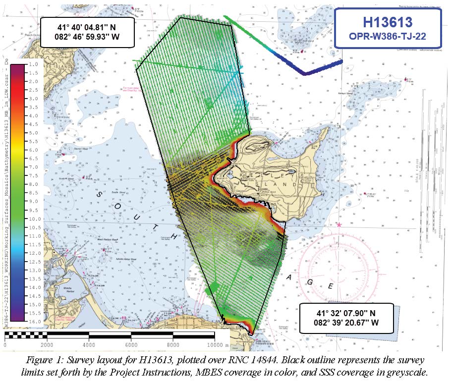
H13613: NOS Hydrographic Survey , 2022-06-15
National Oceanic and Atmospheric Administration, Department of Commerce —
The National Oceanic and Atmospheric Administration (NOAA) has the statutory mandate to collect hydrographic data in support of nautical chart compilation for safe... -
Federal
Physical Solar Model version 3 Direct Normal Irradiance Multi-year Monthly Average
Department of Energy —
This data provides monthly average daily total solar resource averaged over surface cells of 0.038 degrees in both latitude and longitude, or nominally 4 km in size.... -
Federal
Process Monitoring Dataset from the Additive Manufacturing Metrology Testbed (AMMT): Overhang Part X4
National Institute of Standards and Technology —
This dataset includes files from the experiment titled 'OverhangPartX4' pertaining to a three-dimensional (3D) additive manufacturing (AM) build performed on the... -
Federal
H09056: NOS Hydrographic Survey , Patterson Bay and South Arm, Alaska, 1969-09-23
National Oceanic and Atmospheric Administration, Department of Commerce —
The National Oceanic and Atmospheric Administration (NOAA) has the statutory mandate to collect hydrographic data in support of nautical chart compilation for safe... -
University
2011 Las Conchas Post Fire, a136106_sw_nw, CIR
Earth Data Analysis Center, University of New Mexico —
Wilson and Company collected and processed multi-spectral (red, green, blue, near-infrared) digital aerial imagery of the Las Conchas Fire that burned in the Santa Fe... -
Federal
Ridgelines: Department of Interior Definition
Department of Energy —
This dataset represents ridgelines as defined by the Department of Interior (DOI): "Areas within 660 feet of the top of the ridgeline, where a ridgeline has at least... -
Federal
H01845: NOS Hydrographic Survey
National Oceanic and Atmospheric Administration, Department of Commerce —
The National Oceanic and Atmospheric Administration (NOAA) has the statutory mandate to collect hydrographic data in support of nautical chart compilation for safe... -
Federal
H03538A: NOS Hydrographic Survey
National Oceanic and Atmospheric Administration, Department of Commerce —
The National Oceanic and Atmospheric Administration (NOAA) has the statutory mandate to collect hydrographic data in support of nautical chart compilation for safe... -
Federal
H09069: NOS Hydrographic Survey , Nichols Passage, Alaska, 1969-10-19
National Oceanic and Atmospheric Administration, Department of Commerce —
The National Oceanic and Atmospheric Administration (NOAA) has the statutory mandate to collect hydrographic data in support of nautical chart compilation for safe... -
Federal
Wind Turbine Structure Setbacks: Ordinances (2022) and Extrapolated Trends, 115 Hub Height 170 Rotor Diameter
Department of Energy —
This dataset represents wind energy setback requirements from structures based on existing county ordinances as of April 2022. A setback requirement is a minimum... -
Federal
H09371: NOS Hydrographic Survey , Ormand Beach to Flagler Beach, Florida, 1974-08-26
National Oceanic and Atmospheric Administration, Department of Commerce —
The National Oceanic and Atmospheric Administration (NOAA) has the statutory mandate to collect hydrographic data in support of nautical chart compilation for safe... -
Federal
H00925: NOS Hydrographic Survey
National Oceanic and Atmospheric Administration, Department of Commerce —
The National Oceanic and Atmospheric Administration (NOAA) has the statutory mandate to collect hydrographic data in support of nautical chart compilation for safe... -
Federal
H13380: NOS Hydrographic Survey , 2020-08-12
National Oceanic and Atmospheric Administration, Department of Commerce —
The National Oceanic and Atmospheric Administration (NOAA) has the statutory mandate to collect hydrographic data in support of nautical chart compilation for safe... -
Federal
2023 USDA Plant Hardiness Zone Map Mean Annual Extreme Low Temperature Rasters
Department of Agriculture —
These rasters provide the local mean annual extreme low temperature from 1991 to 2020 in an 800m x 800m grid covering the USA (including Puerto Rico) based on... -
Federal
Process Monitoring Dataset from the Additive Manufacturing Metrology Testbed (AMMT): Overhang Part X16
National Institute of Standards and Technology —
This dataset includes files from the experiment titled OverhangPartX16 pertaining to a three-dimensional (3D) additive manufacturing (AM) build performed on the... -
Federal
H09689: NOS Hydrographic Survey , Approaches to Milwaukee Harbor Entrances, Wisconsin, 1977-04-30
National Oceanic and Atmospheric Administration, Department of Commerce —
The National Oceanic and Atmospheric Administration (NOAA) has the statutory mandate to collect hydrographic data in support of nautical chart compilation for safe...

Official websites use .gov
A
.gov website belongs to an official government
organization in the United States.
Secure .gov websites use HTTPS
A
lock (
) or https:// means you’ve safely connected to
the .gov website. Share sensitive information only on official,
secure websites.