
-
Federal
NACP Aboveground Biomass and Carbon Baseline Data, V.2 (NBCD 2000), U.S.A., 2000
National Aeronautics and Space Administration —
The NBCD 2000 (National Biomass and Carbon Dataset for the Year 2000) data set provides a high-resolution (30 m) map of year-2000 baseline estimates of basal area-... -
Federal
LiDAR Derived Biomass, Canopy Height, and Cover for New England Region, USA, 2015
National Aeronautics and Space Administration —
This dataset provides 30 m gridded estimates of aboveground biomass density (AGBD), forest canopy height, and tree canopy coverage for the New England Region of the... -
Federal
BOREAS TE-23 Map Plot Data
National Aeronautics and Space Administration —
The BOREAS TE-23 team collected map plot data in support of its efforts to characterize and interpret information on canopy architecture and understory cover at the... -
Federal
LBA-ECO ND-11 Forest Soil Structure and Nitrate, NW Mato Grosso, Brazil: 2004-2005
National Aeronautics and Space Administration —
This data set reports the results of the analysis of soil samples for Nitrate (NO3) and physical properties that were collected for one year following reduced impact... -
Federal
NPP Boreal Forest: Superior National Forest, USA, 1983-1984, R1
National Aeronautics and Space Administration —
This data set contains two files (.txt format). One file provides ground-based biophysical measurements and above-ground net primary productivity (ANPP) estimates for... -
Federal
Classification of Global Forests for IPCC Aboveground Biomass Tier 1 Estimates, 2020
National Aeronautics and Space Administration —
This dataset provides classes of global forests delineated by status/condition in 2020 at approximately 30-m resolution. The data support generating Tier 1 estimates... -
Federal
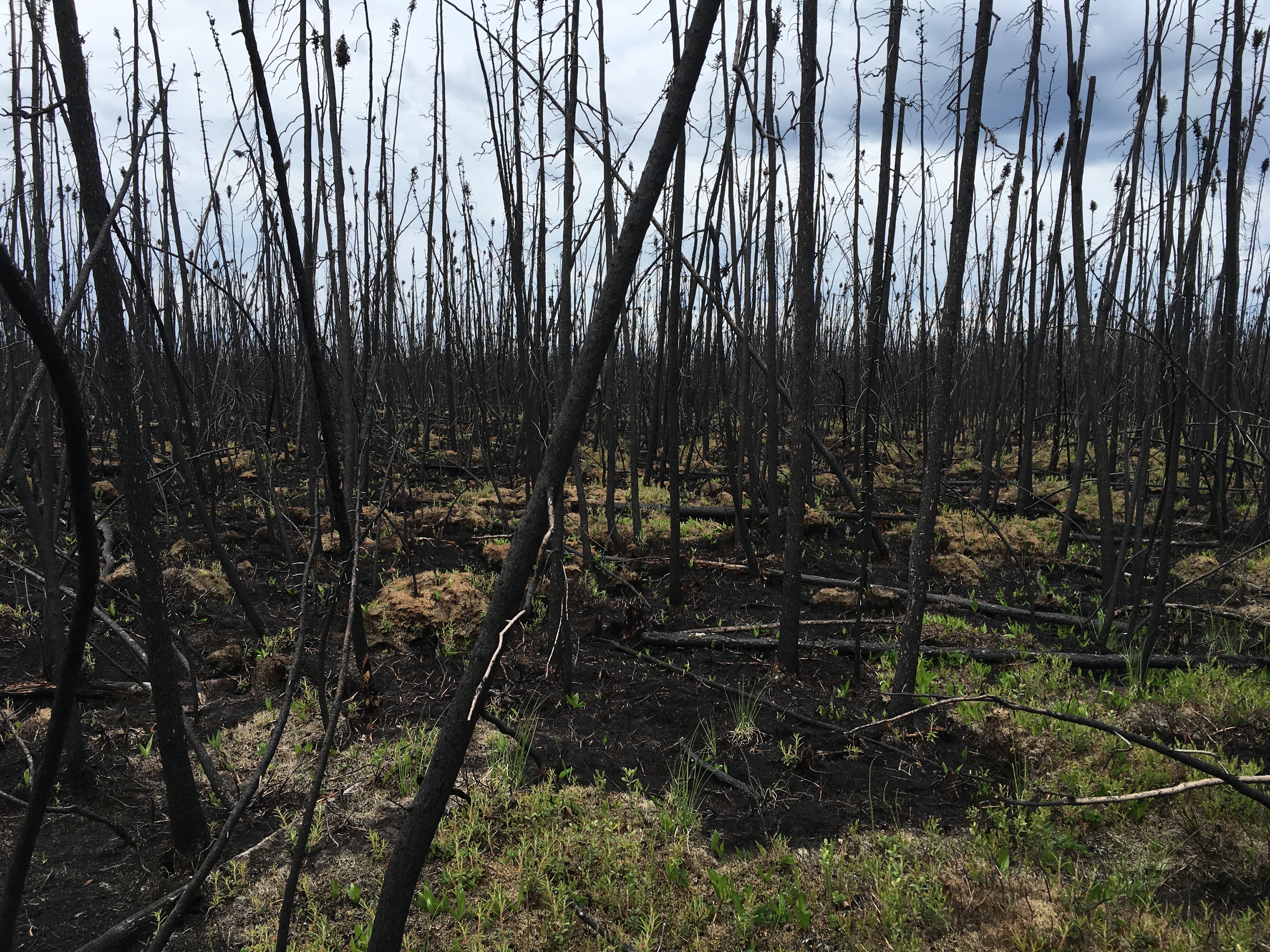
ABoVE: Characterization of Burned and Unburned Boreal Forest Stands, SK, Canada, 2016
National Aeronautics and Space Administration —
This dataset provides the results of field measurements and estimates of carbon stocks and combustion rates that characterize burned and unburned southern boreal... -
Federal
Project dataset for assessing trends and vulnerabilities in the mutualism between whitebark pine (Pinus albicaulis) and Clark’s nutcracker (Nucifraga columbiana) in the Cascades region
Department of the Interior —
These datasets represent inputs into spatial and temporal models associated with a published study assessing trends and vulnerabilities in the mutalism between... -
Federal
Bighorn Canyon National Recreation Area Landscape Context, Raster Data
Department of the Interior —
This zip file contains 21 raster layers representing data from a variety of landscape metrics used to analyze the landscape context of Bighorn Canyon National... -
Federal
LBA-ECO LC-14 Biophysical Measurements, Rainfall Exclusion, Tapajos National Forest
National Aeronautics and Space Administration —
This data set reports forest biophysical measurements from a rainfall exclusion experiment conducted at the km 67 Seca Floresta site, Tapajos National Forest, Brazil... -
Federal
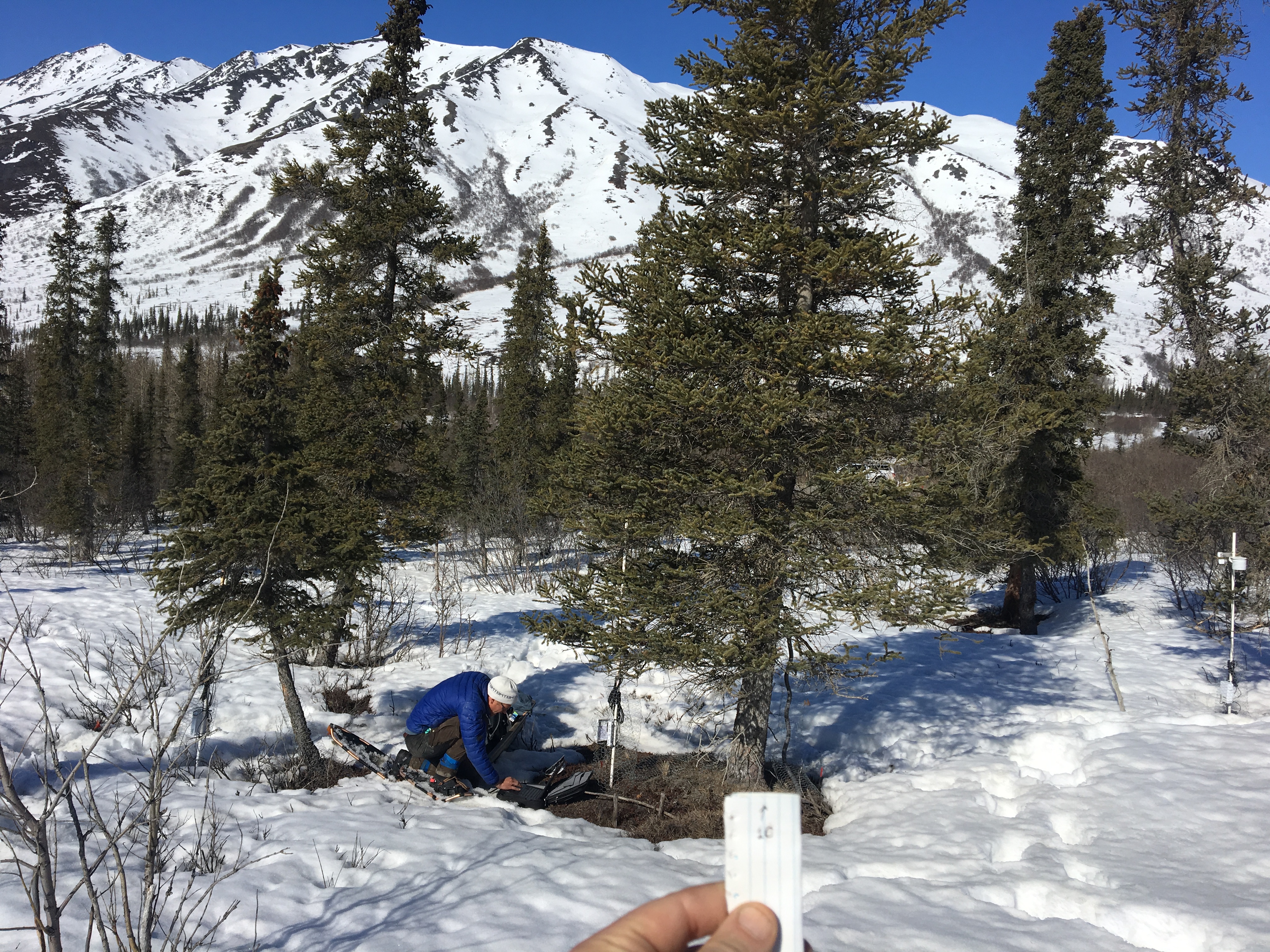
ABoVE: Photochemical Reflectance and Tree Growth, Brooks Range, Alaska, 2018-2019
National Aeronautics and Space Administration —
This dataset provides simultaneous in-situ measurements of the photochemical reflectance index (PRI) and radial tree growth of selected white spruce trees (Picea... -
Federal
BOREAS TE-08 Aspen Bark Chemistry Data
National Aeronautics and Space Administration —
The BOREAS TE-08 team collected pigment density data from aspen bark and leaves from four sites within the BOREAS SSA from 24-May-1994 to 16-Jun-1994 (IFC-1),... -
Federal
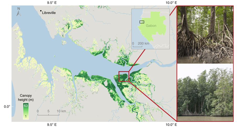
Global Mangrove Distribution, Aboveground Biomass, and Canopy Height
National Aeronautics and Space Administration —
This dataset characterizes the global distribution, biomass, and canopy height of mangrove-forested wetlands based on remotely sensed and in situ field measurement... -
Federal
EnviroAtlas -- Tacoma, WA -- Meter-Scale Urban Land Cover (MULC) Data (2011)
U.S. Environmental Protection Agency —
The Tacoma, WA Meter Urban Land Cover (MULC) dataset was generated from 1-meter image pixel resolution data sourced from 2011 USDA National Agricultural Imagery... -
Federal
SNF Forest Understory Cover Data (Table)
National Aeronautics and Space Administration —
The purpose of the SNF study was to improve our understanding of the relationship between remotely sensed observations and important biophysical parameters in the... -
Federal
Landbird Inventory for Mount Rainier National Park tabular data
Department of the Interior —
The Institute for Bird Populations (IBP) collaborated with personnel at Mount Rainier National Park to initiate a Park-wide inventory of landbirds. The goals of the... -
Federal
NPP Boreal Forest: Siberian Scots Pine Forests, Russia, 1968-1974, R1
National Aeronautics and Space Administration —
This data set contains two files (comma-separated-value format). One file provides components of net primary productivity, standing biomass, age and stand structure,... -
Federal
BOREAS TE-09 NSA Leaf Chlorophyll Density Data
National Aeronautics and Space Administration —
The Boreal Ecosystem-Atmosphere Study (BOREAS) Terrestrial Ecology Team #9 (TE-09) provided several data sets containing information about the state and response of...

Official websites use .gov
A
.gov website belongs to an official government
organization in the United States.
Secure .gov websites use HTTPS
A
lock (
) or https:// means you’ve safely connected to
the .gov website. Share sensitive information only on official,
secure websites.