
-
Federal
Geoecology: County-Level Environmental Data for the United States, 1941-1981
National Aeronautics and Space Administration —
The Geoecology database is a compilation of environmental data for the period 1941 to 1981. The Geoecology database contains selected data on terrain and soils, water... -
Federal
Land Surface Atmospheric Boundary Interaction Product L3 V1(LANDMET) at GES DISC
National Aeronautics and Space Administration —
This product is a multi-variate data compilation that reconciles the variation scales of these multiple measurements from varies resources, merges and maps them into... -
Federal
EMIT L2A Estimated Surface Reflectance and Uncertainty and Masks 60 m V001
National Aeronautics and Space Administration —
The Earth Surface Mineral Dust Source Investigation (EMIT) instrument measures surface mineralogy, targeting the Earth’s arid dust source regions. EMIT is installed... -
Federal
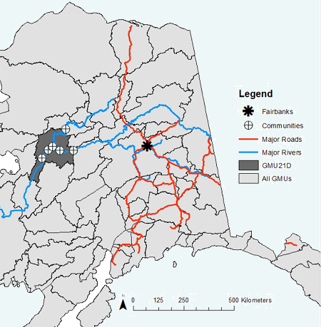
ABoVE: Environmental Conditions During Fall Moose Hunting Seasons, Alaska, 2000-2016
National Aeronautics and Space Administration —
This dataset provides daily and annual air temperature, river water level, and leaf drop dates coincident with the moose (Alces alces) hunting season (September) for... -
Federal
2018 Annual Data Files: Centennial Valley Arctic Grayling Adaptive Management Project, 2011-present
Department of the Interior —
2018's Annual Data files have been uploaded as several digital holdings with data used to support the creation of the Centennial Valley Arctic Grayling Adaptive... -
Federal
Tidal Wetlands Soil Organic Carbon and Estuarine Characteristics, USA, 1972-2015
National Aeronautics and Space Administration —
This dataset provides a synthesis of soil organic carbon (SOC) estimates and a variety of other environmental information from tidal wetlands within estuaries in the... -
Federal
NRT AMSR2 Unified L2B Half-Orbit 25 km EASE-Grid Surface Soil Moisture Beta V2
National Aeronautics and Space Administration —
The Advanced Microwave Scanning Radiometer 2 (AMSR2) instrument on the Global Change Observation Mission - Water 1 (GCOM-W1) provides global passive microwave... -
Federal
NRT AMSR2 Unified Global Swath Surface Precipitation GSFC Profiling Algorithm V2
National Aeronautics and Space Administration —
The Advanced Microwave Scanning Radiometer 2 (AMSR2) instrument on the Global Change Observation Mission - Water 1 (GCOM-W1) provides global passive microwave... -
Federal
Development and Evolution of NASA Satellite Remote Sensing for Ecology
National Aeronautics and Space Administration —
This dataset provides a presentation that highlights the role NASA research and researchers played in developing a wide range of significant, quantitative ecological... -
Federal
PnET-BGC: Modeling Biogeochemical Processes in a Northern Hardwood Forest Ecosystem
National Aeronautics and Space Administration —
This archived model product contains the directions, executables, and procedures for running PnET-BGC to recreate the results of Gbondo-Tugbawa, S.S., C.T. Driscoll ,... -
Federal
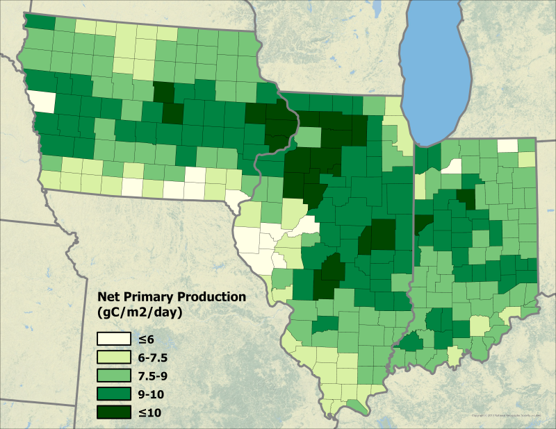
Ecosys Model-Estimated Cropland Carbon Fluxes, Illinois, Indiana, and Iowa, 2001-2018
National Aeronautics and Space Administration —
This dataset contains daily estimates of carbon fluxes in croplands derived from the "ecosys" model covering a portion of the Midwestern US (Illinois, Indiana, and... -
Federal
NOAA/WDS Paleoclimatology - Brown fire data from Water Canyon - IMPD USWAC001
National Oceanic and Atmospheric Administration, Department of Commerce —
This archived Paleoclimatology Study is available from the NOAA National Centers for Environmental Information (NCEI), under the World Data Service (WDS) for... -
Federal
BOREAS TE-20 NSA Soil Lab Data
National Aeronautics and Space Administration —
This data set contains the major soil properties of soil samples collected at the tower flux sites in the NSA. The soil samples were collected by Hugo Veldhuis and... -
Federal
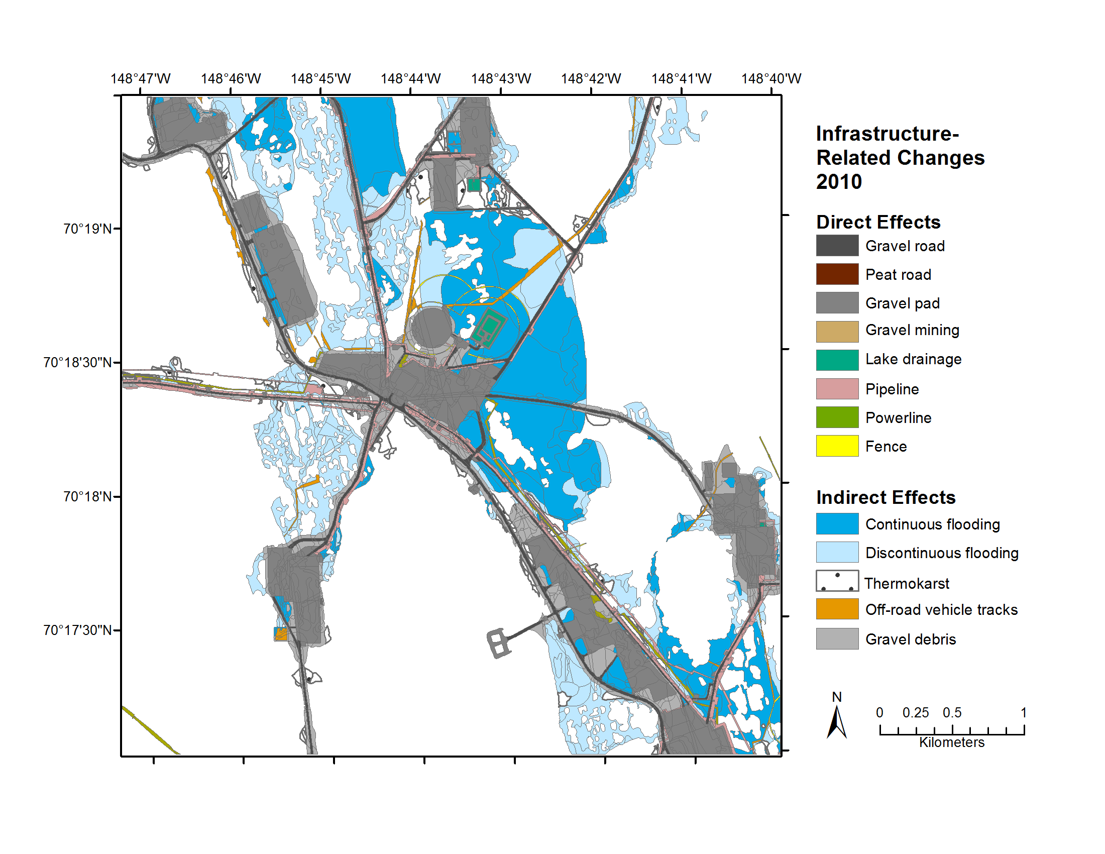
Geobotanical and Impact Map Collection for Prudhoe Bay Oilfield, Alaska, 1972-2010
National Aeronautics and Space Administration —
This data set provides a collection of maps of geoecological characteristics of areas within the Beechey Point quadrangle near Prudhoe Bay on the North slope of... -
Federal
2016 Annual Data Files: Centennial Valley Arctic Grayling Adaptive Management Project, 2011-present
Department of the Interior —
2016's Annual Data files have been uploaded as several digital holdings with data used to support the creation of the Centennial Valley Arctic Grayling Adaptive... -
State
San Francisco Bay and Sacramento-San Joaquin Delta DEM for Modeling, Version 4.3
State of California —
Citation and Main Description: This product is described in Chapter 5 of the 2018 DWR Delta Modeling Section annual report, produced jointly with USGS.... -
Federal
NOAA/WDS Paleoclimatology - Stambaugh fire data from Falling Waters - IMPD USFLW001
National Oceanic and Atmospheric Administration, Department of Commerce —
This archived Paleoclimatology Study is available from the NOAA National Centers for Environmental Information (NCEI), under the World Data Service (WDS) for... -
Federal
Tidal Resource Data from Sequim Bay Inlet, WA, August 2020
Department of Energy —
Data from a Nortek Signature1000 deployed on a lander for 14 days in Aug 2020 in the entrance to Sequim Bay, WA. Raw data were processed using the DOLfYN python... -
Federal
Data for Advanced Metrology Suite for Linking Residual Stress to FundamentalProperties of Thermoset Packaging Materials
National Institute of Standards and Technology —
This repository contains data generated to support and ECTC 2025 conference manuscript titled "Advanced Metrology Suite for Linking Residual Stress to Fundamental...

Official websites use .gov
A
.gov website belongs to an official government
organization in the United States.
Secure .gov websites use HTTPS
A
lock (
) or https:// means you’ve safely connected to
the .gov website. Share sensitive information only on official,
secure websites.