
-
Federal
GRACE/GRACE-FO Level-4 Monthly Global Ocean Mass Anomaly version 01 from NASA MEaSUREs HOMaGE project
National Aeronautics and Space Administration —
This data set contains the monthly Global Ocean Mass Anomalies (goma) since 04/2002, as measured by the GRACE and GRACE Follow-On (G/GFO) satellite missions. The data... -
Federal
MODIS/Aqua Surface Reflectance 8-Day L3 Global 500m SIN Grid V061
National Aeronautics and Space Administration —
The Moderate Resolition Imaging Spectroradiometer (MODIS) Aqua MYD09A1 Version 6.1 product provides an estimate of the surface spectral reflectance of Aqua MODIS... -
Federal
ASTER L2 Surface Reflectance SWIR and ASTER L2 Surface Reflectance VNIR V003
National Aeronautics and Space Administration —
The Terra Advanced Spaceborne Thermal Emission and Reflection Radiometer (ASTER) Surface Reflectance VNIR and SWIR (AST_07) data product contains measures of the... -
Federal
MODIS/Terra+Aqua Land Aerosol Optical Depth Daily L2G Global 1km SIN Grid V061
National Aeronautics and Space Administration —
The MCD19A2 Version 6.1 data product is a Moderate Resolution Imaging Spectroradiometer (MODIS) Terra and Aqua combined Multi-angle Implementation of Atmospheric... -
Federal
VIIRS/NPP Gross Primary Productivity and Net Photosynthesis Gap-Filled 8-Day L4 Global 500m SIN Grid V002
National Aeronautics and Space Administration —
The NASA/NOAA Suomi National Polar-orbiting Partnership (Suomi NPP) Visible Infrared Imaging Radiometer Suite (VIIRS) Gross Primary Productivity (GPP) and Net... -
Federal
CYGNSS Level 3 MRG Science Data Record Version 3.2.2
National Aeronautics and Space Administration —
This dataset contains the version 3.2.2 CYGNSS level 3 science data record merged storm (MRG) wind speed which combines CYGNSS storm-centric gridded (SCG) wind... -
Federal
ECOSTRESS Evapotranspiration PT-JPL Daily L3 Global 70m V001
National Aeronautics and Space Administration —
The ECOsystem Spaceborne Thermal Radiometer Experiment on Space Station (ECOSTRESS) mission measures the temperature of plants to better understand how much water... -
Federal
MODIS/Terra Net Primary Production Gap-Filled Yearly L4 Global 500m SIN Grid V061
National Aeronautics and Space Administration —
The MOD17A3HGF Version 6.1 product provides information about annual Gross and Net Primary Production (GPP and NPP) at 500 meter (m) pixel resolution. Annual Terra... -
Federal
Near Real-Time MODIS/Terra L3 Global Daily 500m SIN Grid Snow Cover, Snow Albedo, and Snow Surface Properties, Version 1
National Aeronautics and Space Administration —
This data set contains the following parameters: snow fraction (on the ground), viewable snow fraction, snow cover duration, snow grain size, dust concentration, snow... -
Federal
ASTER Global Emissivity Dataset, Monthly, 0.05 deg, HDF5 V041
National Aeronautics and Space Administration —
The Terra Advanced Spaceborne Thermal Emission and Reflection Radiometer (ASTER) Global Emissivity Dataset (GED) is a collection of monthly files (see known issues... -
Federal
Mediterranean Sea High Resolution SST L4 Analysis 1/16deg Resolution
National Aeronautics and Space Administration —
CNR MED Sea Surface Temperature provides daily gap-free maps (L4) at 0.0625deg. x 0.0625deg. horizontal resolution over the Mediterranean Sea. The data are obtained... -
Federal
OCO-2 Level 2 spatially ordered geolocated retrievals screened using the IMAP-DOAS Preprocessor (IDP) V11.2 (OCO2_L2_IMAPDOAS) at GES DISC
National Aeronautics and Space Administration —
Version 11.2 is the current version of the data set. Older versions will no longer be available and are superseded by Version 11.2. The Orbiting Carbon Observatory is... -
Federal
OCO-3 Level 2 geolocated XCO2 retrievals results, physical model, Forward Processing V10 (OCO3_L2_Standard) at GES DISC
National Aeronautics and Space Administration —
Version 10 is the current version of the data set. Older versions will no longer be available and are superseded by Version 10. The Orbiting Carbon Observatory -3... -
Federal
Multi-Mission Optimally Interpolated Sea Surface Salinity Global Dataset V1
National Aeronautics and Space Administration —
This is a level 4 product on a 0.25-degree spatial and 4-day temporal grid. The product is derived from the level 2 swath data of three satellite missions: the... -
Federal
ASTER L2 Surface Reflectance VNIR and Crosstalk Corrected SWIR V003
National Aeronautics and Space Administration —
The Terra Advanced Spaceborne Thermal Emission and Reflection Radiometer (ASTER) Surface Reflectance VNIR and Crosstalk Corrected SWIR (AST_07XT) dataset contains... -
Federal
ASTER Digital Elevation Model V003
National Aeronautics and Space Administration —
The Terra Advanced Spaceborne Thermal Emission and Reflection Radiometer (ASTER) Digital Elevation Model (AST14DEM) product is generated using bands 3N (nadir-... -
Federal
CYGNSS Level 3 Science Data Record Version 3.2
National Aeronautics and Space Administration —
This dataset contains the version 3.2 CYGNSS level 3 science data record which provides the average wind speed and mean square slope (MSS) on a 0.2x0.2 degree... -
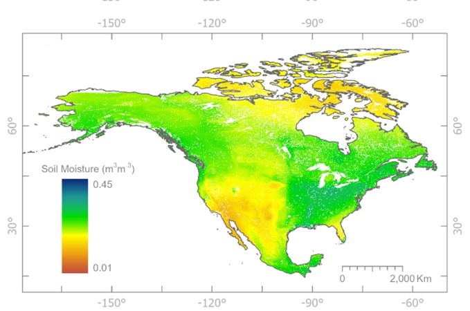
Federal
CYGNSS Level 3 Soil Moisture Version 3.2
National Aeronautics and Space Administration —
The CYGNSS Level 3 Soil Moisture V3.2 dataset is provided by the CYGNSS Science Team of the University of Michigan. It estimates volumetric water content for soils... -
Federal
MODIS/Aqua Surface Reflectance Daily L2G Global 1km and 500m SIN Grid V061
National Aeronautics and Space Administration —
The MYD09GA Version 6.1 product provides an estimate of the surface spectral reflectance of Aqua Moderate Resolution Imaging Spectroradiometer (MODIS) Bands 1 through... -
Federal
MODIS/Aqua Net Evapotranspiration Gap-Filled 8-Day L4 Global 500m SIN Grid V061
National Aeronautics and Space Administration —
The Aqua Moderate Resolution Imaging Spectroradiometer (MODIS) MYD16A2GF Version 6.1 Evapotranspiration/Latent Heat Flux (ET/LE) product is a year-end gap-filled...

Official websites use .gov
A
.gov website belongs to an official government
organization in the United States.
Secure .gov websites use HTTPS
A
lock (
) or https:// means you’ve safely connected to
the .gov website. Share sensitive information only on official,
secure websites.