
-
Federal
Planning the Future by Exploring the Past in Mississippi's Grand Bay - NERRS/NSC(NERRS Science Collaborative)
National Oceanic and Atmospheric Administration, Department of Commerce —
People have harvested oysters in Mississippiâs Grand Bay for more than 4,000 years. Today, that legacy is at a crossroads. Increased pollution from residential and... -
Federal
Democratic Republic of the Congo: Status of the Ebola Outbreak
Department of State —
The Ebola outbreak in the Democratic Republic of Congo–first reported on May 8th, 2018–has killed 27 people so far, but remains isolated to the three health zones:... -
Federal
Renewable Energy Potential Model: Priority Geothermal Leasing Areas ReEDs Results
Department of Energy —
This dataset contains the results of a study conducted by the National Renewable Energy Laboratory (NREL) to identify potential future priority geothermal leasing... -
Federal
GOES-R Series Level 1b EXIS Extreme Ultraviolet Sensor (EUVS) Product in Daily Aggregations
National Oceanic and Atmospheric Administration, Department of Commerce —
The GOES-R Extreme Ultraviolet and X-Ray Irradiance Sensors (EXIS) Extreme Ultraviolet Sensor (EUVS) measures solar spectral irradiance at discrete wavelengths... -
Federal
PREFIRE Spectral Radiance from PREFIRE Satellite 1 R01
National Aeronautics and Space Administration —
PREFIRE (Polar Radiant Energy in the Far InfraRed Experiment) Spectral Radiance from PREFIRE Satellite 1 (PREFIRE_SAT1_1B-RAD) contains calibrated and geolocated... -
Federal
Passive Microwave-derived Annual Snowoff Date Maps, 1988-2023
National Aeronautics and Space Administration —
This dataset provides annual maps of the snowoff (SO) date from 1988-2023 across Alaska and parts of Far East Russia and northwest Canada at a resolution of 6.25 km.... -
Federal
LMOS Surface Mobile EPA-GMAP Ozone Data
National Aeronautics and Space Administration —
LMOS_TraceGas_SurfaceMobile_EPA-GMAP_Data_1 is the Lake Michigan Ozone Study (LMOS) trace gas surface mobile data collected via the Environmental Protection Agency... -
Federal
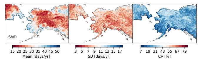
ABoVE: Passive Microwave-derived Annual Snow Melt Duration Date Maps, 1988-2018
National Aeronautics and Space Administration —
This dataset provides the annual period of snowpack melting (i.e., snow melt duration, SMD) across northwest Canada; Alaska, U.S.; and parts of far eastern Russia at... -
Federal
Apex Predators Program Age and Growth Data
National Oceanic and Atmospheric Administration, Department of Commerce —
Apex Predators Program staff have collected vertebral centra from sportfishing tournaments, cruises, commercial fishermen and strandings in the Northeast US since the... -
Federal
International Bathymetric Chart of the Arctic Ocean, Version 1.0
National Oceanic and Atmospheric Administration, Department of Commerce —
The goal of this initiative is to develop a digital data base that contains all available bathymetric data north of 64 degrees North, for use by mapmakers,... -
Federal
Satellite Tagged Net Locations NWHI 2018 - 2021
National Oceanic and Atmospheric Administration, Department of Commerce —
This pilot study follows the movements of 6 derelict fishing nets over time to study how far derelict nets can travel within an atoll, and how long they remain... -
Federal
Hyperspectral Imagery for the Main Eight Hawaiian Islands:Molokai (330-0612-332211)
National Oceanic and Atmospheric Administration, Department of Commerce —
This project is a cooperative effort among the National Ocean Service, National Centers for Coastal Ocean Science, Center for Coastal Monitoring and Assessment; the... -
Federal
Hyperspectral Imagery for the Main Eight Hawaiian Islands:Oahu (204a-0613-272217)
National Oceanic and Atmospheric Administration, Department of Commerce —
This project is a cooperative effort among the National Ocean Service, National Centers for Coastal Ocean Science, Center for Coastal Monitoring and Assessment; the... -
Federal
Hyperspectral Imagery for the Main Eight Hawaiian Islands:Oahu (206-0613-332211)
National Oceanic and Atmospheric Administration, Department of Commerce —
This project is a cooperative effort among the National Ocean Service, National Centers for Coastal Ocean Science, Center for Coastal Monitoring and Assessment; the... -
Federal
Hyperspectral Imagery for the Main Eight Hawaiian Islands:Oahu (202-0612-332211)
National Oceanic and Atmospheric Administration, Department of Commerce —
This project is a cooperative effort among the National Ocean Service, National Centers for Coastal Ocean Science, Center for Coastal Monitoring and Assessment; the... -
Federal
Hyperspectral Imagery for the Main Eight Hawaiian Islands:Maui (310-0620-332211)
National Oceanic and Atmospheric Administration, Department of Commerce —
This project is a cooperative effort among the National Ocean Service, National Centers for Coastal Ocean Science, Center for Coastal Monitoring and Assessment; the... -
Federal
Hyperspectral Imagery for the Main Eight Hawaiian Islands:Oahu (206-0613-272217)
National Oceanic and Atmospheric Administration, Department of Commerce —
This project is a cooperative effort among the National Ocean Service, National Centers for Coastal Ocean Science, Center for Coastal Monitoring and Assessment; the... -
Federal
Hyperspectral Imagery for the Main Eight Hawaiian Islands:Oahu (211-0612-332211)
National Oceanic and Atmospheric Administration, Department of Commerce —
This project is a cooperative effort among the National Ocean Service, National Centers for Coastal Ocean Science, Center for Coastal Monitoring and Assessment; the... -
Federal
Hyperspectral Imagery for the Main Eight Hawaiian Islands:Oahu (203a-0613-272217)
National Oceanic and Atmospheric Administration, Department of Commerce —
This project is a cooperative effort among the National Ocean Service, National Centers for Coastal Ocean Science, Center for Coastal Monitoring and Assessment; the... -
Federal
Data logger database - Physical and biological effects of fish-friendly tide gates
National Oceanic and Atmospheric Administration, Department of Commerce —
The purpose of this one-time stand-alone study is to evaluate how effective "fish-friendly" or self-regulating tide gates (SRTs) are at increasing connectivity for...

Official websites use .gov
A
.gov website belongs to an official government
organization in the United States.
Secure .gov websites use HTTPS
A
lock (
) or https:// means you’ve safely connected to
the .gov website. Share sensitive information only on official,
secure websites.