
-
Federal
Multispectral Imagery, NDVI, and Terrain Models, Big Trail Lake, Fairbanks, AK, 2019
National Aeronautics and Space Administration —
This dataset provides multispectral reflectance imagery (green at 550 nm, red at 660 nm, red edge at 735 nm, and near-infrared at 790 nm), normalized difference... -
Federal
RLC Forest Cover of the Former Soviet Union, 1973
National Aeronautics and Space Administration —
This data set is a 1:15 million scale forest cover map for the land area of the Former Soviet Union. Twenty-two land cover classes are distinguished, of which 20 are... -
Federal
Archive of Census Related Products (ACRP): 1990 ZIP Equivalency Files
National Aeronautics and Space Administration —
The 1990 Zip Equivalency Files portion of the Archive of Census Related Products (ACRP) contains population and housing data derived from the U.S. Census Bureau's... -
Federal
Global Soil Types, 0.5-Degree Grid (Modified Zobler)
National Aeronautics and Space Administration —
A global data set of soil types is available at 0.5-degree latitude by 0.5-degree longitude resolution. There are 106 soil units, based on Zobler?s (1986) assessment... -
Federal
Automobile Campgrounds (walk-ins and other site features) in the North Cascades National Park Service Complex, nautocampp1.shp
Department of the Interior —
ArcGIS shapefile depicting point locations of automobile campgrounds in the Ross Lake National Recreation Area of the North Cascades National Park Service Complex.... -
Federal
Lakes within the North Cascades National Park Service Complex and surrounding areas, nlakesg1.shp
Department of the Interior —
ArcGIS shapefile of lake polygons. This data set shows where lakes are located within the North Cascades National Park Service Complex and vicinity. -
Federal
Seattle City Light Power Lines in the North Cascades National Park Service Complex, nsclpowerl1.shp
Department of the Interior —
The ArcGIS shapefile (lines) represents the segment of the Seattle City Light power lines within North Cascades National Park Service Complex (from Ross Dam to just... -
Federal
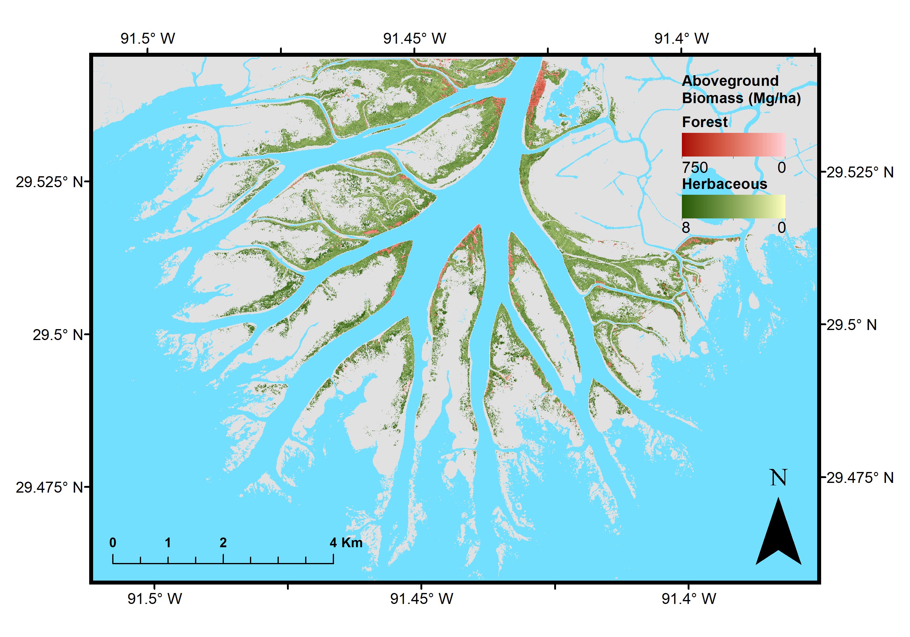
Pre-Delta-X: Aboveground Biomass and Vegetation Maps, Wax Lake Delta, LA, USA, 2016
National Aeronautics and Space Administration —
This dataset includes aboveground biomass (AGB) and vegetation of herbaceous and forest wetland at 5.4 m resolution across the Wax Lake Delta (WLD) in Southern... -
Federal
ASTER Global Water Bodies Database NetCDF V001
National Aeronautics and Space Administration —
The Terra Advanced Spaceborne Thermal Emission and Reflection Radiometer (ASTER) Global Water Bodies Database (ASTWBD) Version 1 data product provides global coverage... -
Federal
SCAMS/Nimbus-6 Images of Brightness Temperatures, Water Vapor and Temperature on 70-mm Film V001 (SCAMSN6IM) at GES DISC
National Aeronautics and Space Administration —
The SCAMSN6IM data product consists of images of brightness temperatures, water vapor and temperature on 70 mm film strips from the Nimbus-6 Scanning Microwave... -
Federal
Remote Sensing Derived Topsoil and Agricultural Economic Losses, Midwestern USA
National Aeronautics and Space Administration —
This dataset provides estimates of topsoil loss and economic loss associated with decreased crop productivity resulting from topsoil loss at county- and state-levels... -
Federal
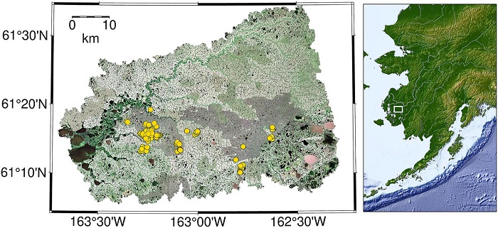
CO2 and CH4 Fluxes from Waterbodies, Yukon-Kuskokwim Delta, Alaska, 2016-2019
National Aeronautics and Space Administration —
This dataset provides estimates of carbon dioxide (CO2) and methane (CH4) diffusive fluxes from waterbodies, and watershed landcover data for the central-interior of... -
Federal
CMS: LiDAR Data for Forested Areas in Paragominas, Para, Brazil, 2012-2014
National Aeronautics and Space Administration —
This data set provides raw LiDAR point cloud data and derived Digital Terrain Models (DTMs) for five forested areas in the municipality of Paragominas, Para, Brazil,... -
Federal
Global Food Security-support Analysis Data (GFSAD) Cropland Extent 2015 Europe, Central Asia, Russia, Middle East product 30 m V001
National Aeronautics and Space Administration —
The NASA Making Earth System Data Records for Use in Research Environments (MEaSUREs) Global Food Security-support Analysis Data (GFSAD) data product provides... -
Federal
ASTER Global Water Bodies Database V001
National Aeronautics and Space Administration —
The Terra Advanced Spaceborne Thermal Emission and Reflection Radiometer (ASTER) Global Water Bodies Database (ASTWBD) Version 1 data product provides global coverage... -
Federal
Delta-X: Digital Elevation Model, MRD, LA, USA, 2021
National Aeronautics and Space Administration —
This dataset provides an updated digital elevation model (DEM) for the Atchafalaya and Terrebonne basins in coastal Louisiana, USA. The DEM is updated from the Pre-... -
Federal
Arctic Vegetation Plots at Atqasuk, Alaska, 1975, 2000, and 2010
National Aeronautics and Space Administration —
This data set provides vegetation species abundance data collected in 1975 from 60 sites on the Arctic Coastal Plain near Atqasuk, Alaska, as well as environmental... -
Federal
BOREAS Agriculture Canada Central Saskatchewan Vector Soils Data, R1
National Aeronautics and Space Administration —
This data set provides soil descriptions for forested areas in the BOREAS southern study area (SSA) in central Saskatchewan, Canada provided by Agriculture Canada.... -
Federal
Delta-X: Sonar Bathymetry Survey of Channels, MRD, Louisiana, 2021
National Aeronautics and Space Administration —
This dataset includes bathymetry data for water channels in a portion of the Mississippi River Delta (MRD) of coastal Louisiana. The data were collected using sonar...

Official websites use .gov
A
.gov website belongs to an official government
organization in the United States.
Secure .gov websites use HTTPS
A
lock (
) or https:// means you’ve safely connected to
the .gov website. Share sensitive information only on official,
secure websites.