
-
Federal
China Dimensions Data Collection: Fundamental GIS: Digital Chart of China, 1:1M, Version 1
National Aeronautics and Space Administration —
The Fundamental GIS: Digital Chart of China, 1:1M, Version 1 consists of vector maps of China and surrounding areas. The maps include roads, railroads, drainage... -
Federal
Global Human Built-up And Settlement Extent (HBASE) Dataset From Landsat
National Aeronautics and Space Administration —
The Global Human Built-up And Settlement Extent (HBASE) Dataset from Landsat is a global map of HBASE derived from the Global Land Survey (GLS) Landsat dataset for... -
Federal
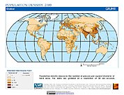
Global Rural-Urban Mapping Project, Version 1 (GRUMPv1): Population Density Grid
National Aeronautics and Space Administration —
The Global Rural-Urban Mapping Project, Version 1 (GRUMPv1): Population Density Grid estimates population per square km for the years 1990, 1995, and 2000 by 30 arc-... -
Federal
Global 1-km Downscaled Population Base Year and Projection Grids Based on the Shared Socioeconomic Pathways, Revision 01
National Aeronautics and Space Administration —
The Global 1-km Downscaled Population Base Year and Projection Grids Based on the Shared Socioeconomic Pathways, Revision 01, data set consists of global urban,... -
Federal
SDG Indicator 11.7.1: Urban Public Space, Availability and Access, 2023 Release
National Aeronautics and Space Administration —
The SDG Indicator 11.7.1: Urban Public Space, Availability and Access, 2023 Release, part of the SDGI collection, measures the average share of the built-up area of a... -
Federal
China Dimensions Data Collection: China Administrative Regions GIS Data: 1:1M, County Level, 1 July 1990
National Aeronautics and Space Administration —
The China Administrative Regions GIS Data: 1:1M, County Level, 1 July 1990 consists of geographic boundary data for the administrative regions of China as of 1 July... -
Federal
West Africa Coastal Vulnerability Mapping: Demographic and Health Survey Data Sets
National Aeronautics and Space Administration —
The West Africa Coastal Vulnerability Mapping: Demographic and Health Survey Data Sets present grids of maternal education levels and household wealth based on... -
Federal
Gridded Population of the World, Version 3 (GPWv3): Land and Geographic Unit Area Grids
National Aeronautics and Space Administration —
The Gridded Population of the World, Version 3 (GPWv3): Land and Geographic Unit Area Grids measure land areas in square kilometers and the mean Unit size... -
Federal
China Dimensions Data Collection: Agricultural Statistics of the People's Republic of China: 1949-1990
National Aeronautics and Space Administration —
The Agricultural Statistics of the People's Republic of China, 1949-1990 is an historical collection of agricultural statistical data compiled by China's State... -
Federal
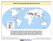
Global Earthquake Mortality Risks and Distribution
National Aeronautics and Space Administration —
The Global Earthquake Mortality Risks and Distribution is a 2.5 minute grid of global earthquake mortality risks. Gridded Population of the World, Version 3 (GPWv3)... -
Federal
Anthropogenic Biomes of the World, Version 2: 1700
National Aeronautics and Space Administration —
The Anthropogenic Biomes of the World, Version 2: 1700 data set describes anthropogenic transformations within the terrestrial biosphere caused by sustained direct... -
Federal
China Dimensions Data Collection: Chinese County-Level Data on Hospitals and Epidemiology Stations, 1950-1985
National Aeronautics and Space Administration —
The China Dimensions Data Collection: Chinese County-Level Data on Hospitals and Epidemiology Stations, 1950-1985 consists of hospital and epidemiological station... -
Federal
Global Rural-Urban Mapping Project, Version 1 (GRUMPv1): Population Count Grid
National Aeronautics and Space Administration —
The Global Rural-Urban Mapping Project, Version 1 (GRUMPv1): Population Count Grid estimates human population for the years 1990, 1995, and 2000 by 30 arc-second (1... -
Federal
Low Elevation Coastal Zone (LECZ) Urban-Rural Population and Land Area Estimates, Version 3
National Aeronautics and Space Administration —
The Low Elevation Coastal Zone (LECZ) Urban-Rural Population and Land Area Estimates, Version 3 data set contains land areas with urban, quasi-urban, rural, and total... -
Federal
West Africa Coastal Vulnerability Mapping: Population Projections, 2030 and 2050
National Aeronautics and Space Administration —
The West Africa Coastal Vulnerability Mapping: Population Projections, 2030 and 2050 data set is based on an unreleased working version of the Gridded Population of... -
Federal
Millennium Ecosystem Assessment: MA Scenarios
National Aeronautics and Space Administration —
The Millennium Ecosystem Assessment: MA Scenarios provides data and information on population, income, cereal production and consumption, meat production and... -
Federal
Global Estimated Net Migration Grids by Decade: 1970-2000
National Aeronautics and Space Administration —
The Global Estimated Net Migration by Decade: 1970-2000 data set provides estimates of net migration over the three decades from 1970 to 2000. Because of the lack of... -
Federal
West Africa Coastal Vulnerability Mapping: Social Vulnerability Indices
National Aeronautics and Space Administration —
The West Africa Coastal Vulnerability Mapping: Social Vulnerability Indices data set includes three indices: Social Vulnerability, Population Exposure, and Poverty... -
Federal
Gridded Population of the World, Version 3 (GPWv3): Centroids
National Aeronautics and Space Administration —
The Gridded Population of the World, Version 3 (GPWv3): Centroids consists of estimates of human population counts and densities for the years 1990, 1995, 2000, 2005,...

Official websites use .gov
A
.gov website belongs to an official government
organization in the United States.
Secure .gov websites use HTTPS
A
lock (
) or https:// means you’ve safely connected to
the .gov website. Share sensitive information only on official,
secure websites.