
-
Federal
Sentinel-6 NASA/JPL GNSS-RO Non-Time-Critical Level 2 V1 (S6A_RO_2__NTC_NC__) at GES DISC
National Aeronautics and Space Administration —
This dataset provides the L2 Global Navigation Satellite System (GNSS) Radio-Occultation (RO) Non-Time-Critical (NTC) retrieval generated by NASA's Jet Propulsion... -
Federal
SeaWiFS Deep Blue Aerosol Optical Depth and Angstrom Exponent Daily Level 3 Data Gridded at 0.5 Degrees V004 (SWDB_L305) at GES DISC
National Aeronautics and Space Administration —
The SeaWiFS Deep Blue (SWDB) Level 3 daily global gridded (0.5 x 0.5 deg) data is derived from SeaWiFS Deep Blue Level 2 data. In most cases, each data field... -
Federal
SBUV2/NOAA-11 Ozone (O3) Profile and Total Column Ozone 1 Month Zonal Mean L3 Global 5.0 degree Latitude Zones V1 (SBUV2N11L3zm) at GES DISC
National Aeronautics and Space Administration —
The Solar Backscattered Ultraviolet (SBUV) from NOAA-11 Level-3 monthly zonal mean (MZM) product (SBUV2N11L3zm) is derived from the Level-2 retrieved ozone profiles.... -
Federal
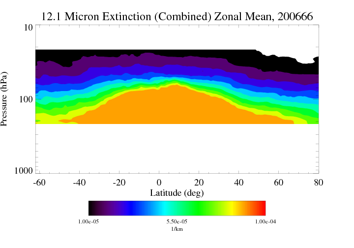
HIRDLS/Aura Level 3 Extinction at 12.1 Microns 1deg Lat Zonal Fourier Coefficients V007 (H3ZFC12MEXT) at GES DISC
National Aeronautics and Space Administration —
The "HIRDLS/Aura Level 3 Extinction at 12.1 Microns Zonal Fourier Coefficients" version 7 data product (H3ZFC12MEXT) contains the entire mission (~3 years) of HIRDLS... -
Federal
HIRS/Nimbus-6 Images of Brightness Temperature on 70 mm Film V001 (HIRSN6IM) at GES DISC
National Aeronautics and Space Administration —
The HIRSN6IM data product consists of images of brightness temperatures on 70 mm film strips from the Nimbus-6 High Resolution Infrared Radiation Sounder. Each... -
Federal
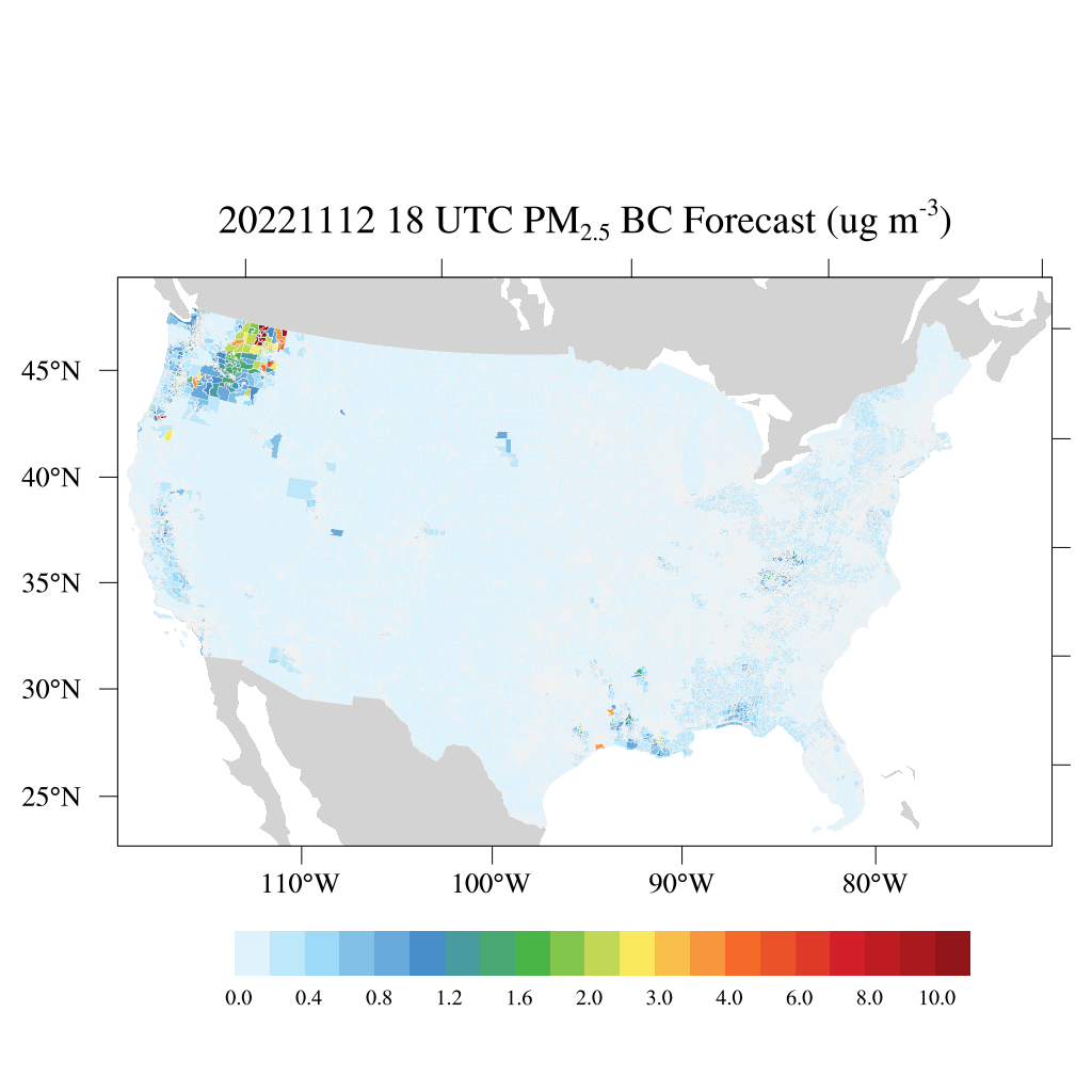
HAQES 3-Hourly Ensemble mean surface PM2.5 Black Carbon concentration at census level, North America V1 (HAQES_NA_PM25_BC_CENSUS) at GES DISC
National Aeronautics and Space Administration —
This product provides HAQES 3-hourly ensemble mean surface PM2.5 Black Carbon concentration at the census level over the continental United States (CONUS). The... -
Federal
HAQES 3-Hourly Ensemble mean surface total PM2.5 concentration at census level, North America V1 (HAQES_NA_PM25_TOT_CENSUS) at GES DISC
National Aeronautics and Space Administration —
This product provides HAQES 3-hourly ensemble mean surface total PM2.5 concentration at the census level over the continental United States (CONUS). The Hazardous Air... -
Federal
HIRDLS/Aura Level 3 Chlorine Nitrate (ClONO2) 1deg Lat Zonal Fourier Coefficients V007 (H3ZFCCLONO2) at GES DISC
National Aeronautics and Space Administration —
The "HIRDLS/Aura Level 3 Chlorine Nitrate (ClONO2) Zonal Fourier Coefficients" version 7 data product (H3ZFCCLONO2) contains the entire mission (~3 years) of HIRDLS... -
Federal
HIRDLS-MLS/Aura Level 3 Monthly 10 x 20 deg Ice Water Content V002 (HIRMLS3IWC) at GES DISC
National Aeronautics and Space Administration —
HIRMLS3IWC is the Joint EOS High Resolution Dynamics Limb Sounder (HIRDLS) and Microwave Limb Sounder (MLS) monthly 10 degreee lat x 20 degreee lon gridded product... -
Federal
MERRA2_CNN_HAQAST bias corrected global hourly surface total PM2.5 mass concentration, V1 (MERRA2_CNN_HAQAST_PM25) at GES DISC
National Aeronautics and Space Administration —
This product provides MERRA-2 bias-corrected global hourly surface total PM2.5 mass concentration with the same horizontal spatial resolution as MERRA-2, covering a... -
Federal
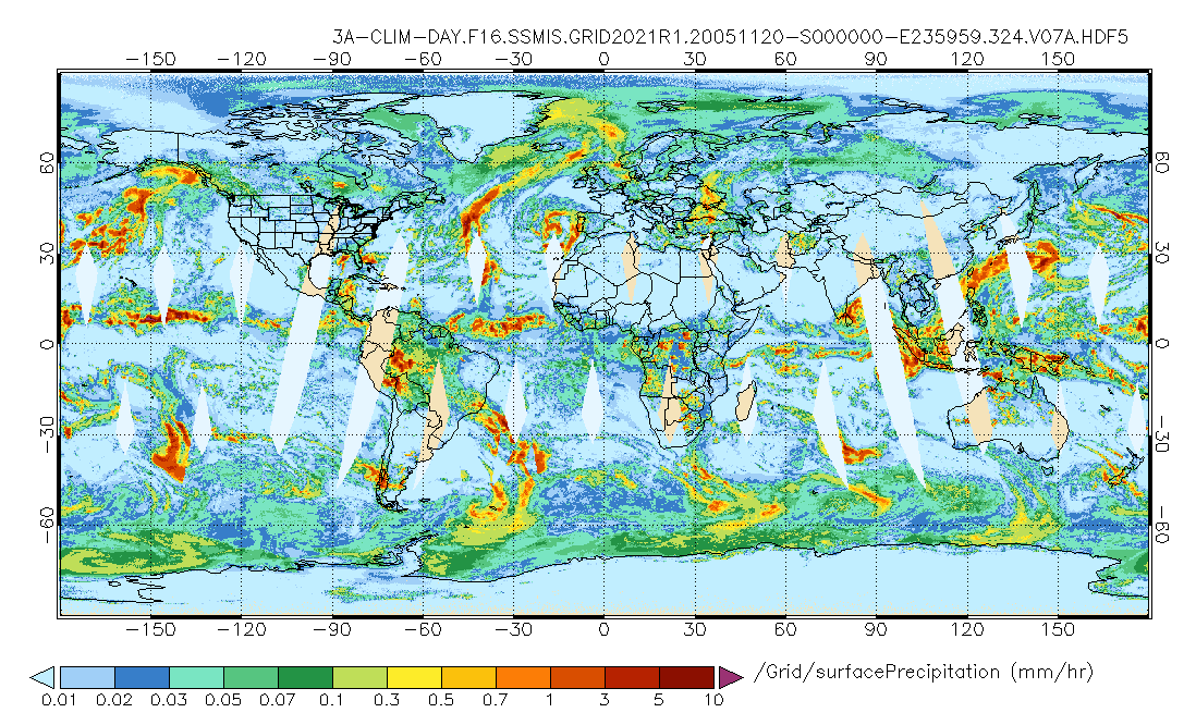
GPM SSMIS on F16 (GPROF) Climate-based Radiometer Precipitation Profiling L3 1 day 0.25 degree x 0.25 degree V07 (GPM_3GPROFF16SSMIS_DAY_CLIM) at GES DISC
National Aeronautics and Space Administration —
Version 07 is the current version of the data set. Older versions will no longer be available and have been superseded by Version 07. The "CLIM" products differ from... -
Federal
GPM MHS on METOP-C (GPROF) Climate-based Radiometer Precipitation Profiling L2A 1.5 hours 17 km V07 (GPM_2AGPROFMETOPCMHS_CLIM) at GES DISC
National Aeronautics and Space Administration —
Version 07 is the current version of the data set. Older versions are no longer available and have been superseded by Version 07. The "CLIM" products differ from... -
Federal
VISSR/SMS-2 Level 1 Atmospheric and Oceanographic Image Processing System (AOIPS) Data V001 (VISSRSMS2L1AOIPS) at GES DISC
National Aeronautics and Space Administration —
VISSRSMS2L1AOIPS is the Visible Infrared Spin-Scan Radiometer (VISSR) Level 1 Atmospheric and Oceanographic Image Processing System (AOIPS) data product from the... -
Federal
VISSR/SMS-1 Visible Imagery on 70mm Film V001 (VISSRSMS1IMVIS) at GES DISC
National Aeronautics and Space Administration —
VISSRSMS1IMVIS is the Visible Infrared Spin-Scan Radiometer (VISSR) Visible Imagery on 70mm Film data product from the first Synchronous Meteorological Satellite... -
Federal
TROPICS03 L2B Neural-network Atmospheric Vertical Temperature & Moisture Profiles V1.0
National Aeronautics and Space Administration —
The "Time-Resolved Observations of Precipitation structure and storm Intensity with a Constellation of Smallsats" (TROPICS) mission has a goal of providing nearly... -
Federal
TROPESS CrIS-SNPP L2 Methane for Australian Fires, Standard Product V1 (TRPSDL2CH4CRSAUS) at GES DISC
National Aeronautics and Space Administration —
The TROPESS CrIS-SNPP L2 Methane for Australian Fires, Standard Product contains the vertical distribution of the retrieved atmospheric state of methane (CH4), formal... -
Federal
TROPESS CrIS-SNPP L2 Ammonia for West Coast Fires, Standard Product V1 (TRPSDL2NH3CRSWCF) at GES DISC
National Aeronautics and Space Administration —
The TROPESS CrIS-SNPP L2 Ammonia for West Coast Fires, Standard Product contains the vertical distribution of the retrieved atmospheric state of ammonia (NH3), formal... -
Federal
TROPICS05 L1B Orbital Geolocated Native-Resolution Brightness Temperatures V0.2
National Aeronautics and Space Administration —
The "Time-Resolved Observations of Precipitation structure and storm Intensity with a Constellation of Smallsats" (TROPICS) mission has a goal of providing nearly... -
Federal
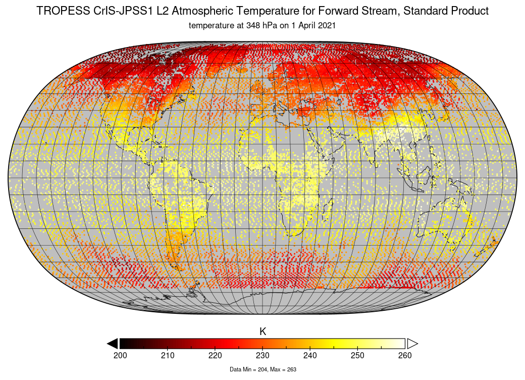
TROPESS CrIS-JPSS1 L2 Atmospheric Temperature for Forward Stream, Standard Product V1 (TRPSDL2TATMCRS1FS) at GES DISC
National Aeronautics and Space Administration —
The TROPESS CrIS-JPSS1 L2 Atmospheric Temperature for Forward Stream, Standard Product contains the vertical distribution of the retrieved atmospheric state of... -
Federal
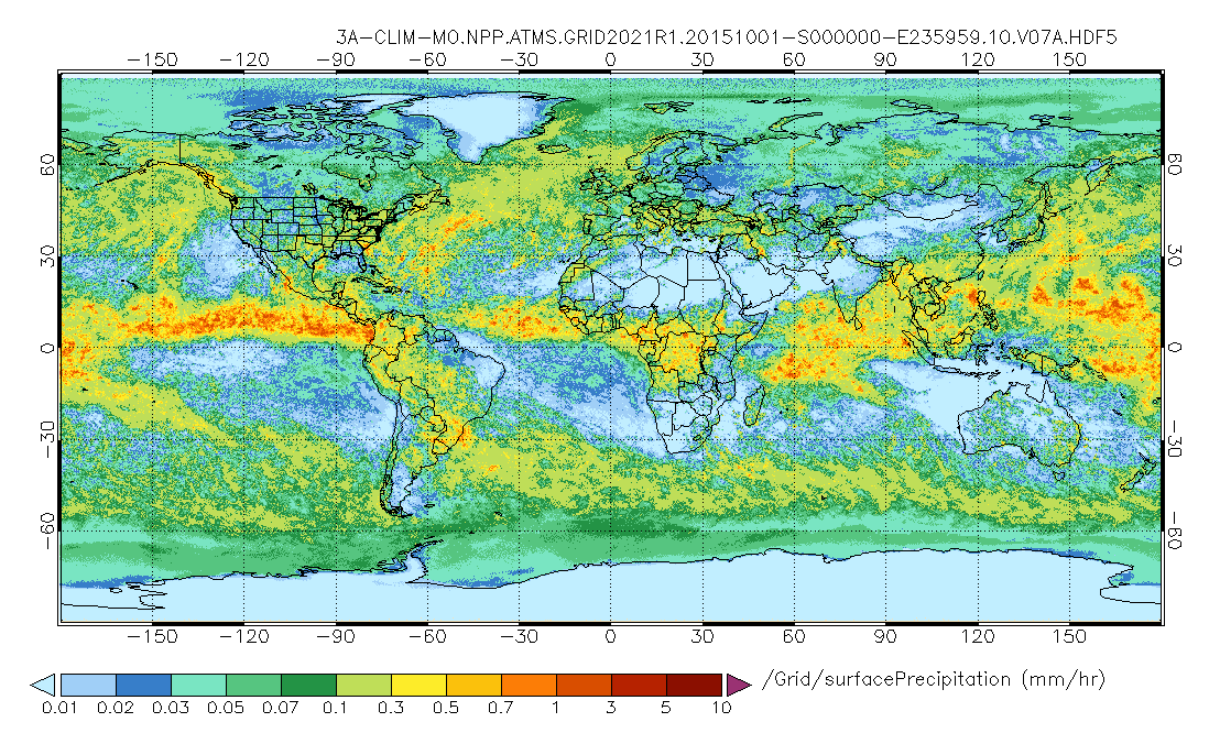
GPM ATMS on SUOMI-NPP (GPROF) Radiometer Precipitation Profiling L3 1 month 0.25 degree x 0.25 degree V07 (GPM_3GPROFNPPATMS_CLIM) at GES DISC
National Aeronautics and Space Administration —
Version 07 is the current version of the data set. Older versions are no longer available and have been superseded by Version 07.The "CLIM" products differ from their...

Official websites use .gov
A
.gov website belongs to an official government
organization in the United States.
Secure .gov websites use HTTPS
A
lock (
) or https:// means you’ve safely connected to
the .gov website. Share sensitive information only on official,
secure websites.