

401 datasets found for "Infrastructure"
-
University
Cadastral PLSS Standardized Data - PLSSPoints (Carlsbad) - Version 1.1
Earth Data Analysis Center, University of New Mexico —
This feature class is part of the Cadastral National Spatial Data Infrastructure (NSDI) CADNSDI publication data set for rectangular and non-rectangular Public Land... -
Federal
BLM AZ Baaj Nwaavjo Itah Kukveni - Ancestral Footprints of the Grand Canyon National Monument (Polygon)
Department of the Interior —
This feature-dataset depicts the boundaries of the Baaj Nwaavjo I’tah Kukveni – Ancestral Footprints of the Grand Canyon National Monument in Arizona. Baaj nwaavjo... -
State
Watershed Restoration Grant Awards - CDFW [ds2663]
State of California —
PROPOSITION 1 GRANTS The Water Quality, Supply, and Infrastructure Improvement Act of 2014 (Proposition 1) provides funding to implement the three broad objectives of... -
Federal
Black Carbon and related environmental data for fate and transport
U.S. Environmental Protection Agency —
We determined soil hydrology, soil carbon pools (organic carbon, black carbon, and inorganic carbon) from urban soil assessments (surface and sub-surface horizons)... -
Federal
Offshore Wind - Interarray Cables (Proposed or Installed)
Department of the Interior —
MetadataThese data represent the currently proposed cable linkages between proposed or installed wind turbines and/or proposed offshore substation(s). In some cases,... -
University
Cadastral PLSS Standardized Data - PLSSIntersected (Douglas) - Version 1.1
Earth Data Analysis Center, University of New Mexico —
This feature class is part of the Cadastral National Spatial Data Infrastructure (NSDI) CADNSDI publication data set for rectangular and non-rectangular Public Land... -
Federal
PADUS FS Proclaimed NF and National Grassland Boundaries (Feature Layer)
Department of Agriculture —
An area depicting designated land boundaries which are designated by proclamation. This data is intended for read-only use. The PAD-US feature classes were developed... -
University
Cadastral PLSS Standardized Data - PLSSReferenceGrid, SW - Version 1.1
Earth Data Analysis Center, University of New Mexico —
This feature class is part of the Cadastral National Spatial Data Infrastructure (NSDI) CADNSDI publication data set for rectangular and non-rectangular Public Land... -
State
Medium and Heavy Duty Infrastructure
State of California —
Medium- and heavy-duty (MDHD) zero-emission vehicle (ZEV) hydrogen refueling and charging station data was collected from the following agencies: California Air... -
Federal
BLM ID State Boundary GCDB Line Hub
Department of the Interior —
This dataset portrays the state boundary based on the 2010 Cadastral National Spatial Data Infrastructure (CADNSDI) Geographic Coordinate Data Base (GCDB)... -
Bridge Undersegments
District of Columbia —
This file contains posted weights and clearances for vehicle bridges in the District. -
Federal
EnviroAtlas - Des Moines, IA - Tree Cover Configuration and Connectivity, Water Background
U.S. Environmental Protection Agency —
This EnviroAtlas dataset categorizes forest land cover into structural elements (e.g. core, edge, connector, etc.). In this community, Forest is defined as Trees... -
State
Facilities for Wildland Fire Protection
State of California —
This dataset is intended to provide a statewide depiction of CALFIRE and contract facilities for fire suppression. It includes state and local funded fire stations,... -
State
i17 California Jurisdictional Dams
State of California —
This dataset is a feature class identifying all dams currently under the jurisdiction of the Division of Safety of Dams (DSOD). The dataset is extracted from DSOD... -
Federal
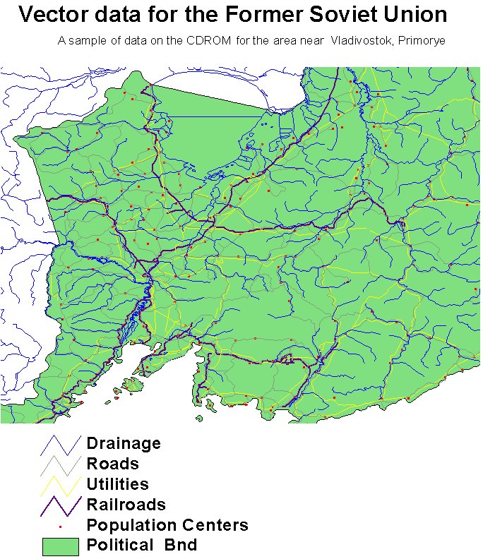
RLC Selected Infrastructure Data for the Former Soviet Union, 1993
National Aeronautics and Space Administration —
This data set consists of roads, drainage, railroads, utilities, and population center information in readily usable vector format for the land area of the Former... -
Federal
LBA-ECO LC-24 Historical Roads of the Legal Amazon: 1968-1993
National Aeronautics and Space Administration —
Understanding the impact of road investments on deforestation is part of a complete evaluation of the expansion of infrastructure for development.We find evidence of... -
Federal
LBA-ECO LC-01 City, Community, and Road Maps, Northern Ecuadorian Amazon: 1990-2002
National Aeronautics and Space Administration —
This data set contains the boundaries of the four major cities in the Northern Ecuadorian Amazon, the locations of primary communities in the colonist settlement... -
Federal
Outer Continental Shelf Oil and Natural Gas Pipelines - Gulf of America Region NAD 27 NGDA
Department of the Interior —
This polyline data set contains the locations of oil and gas pipelines in the Gulf of America Outer Continental Shelf federal waters that are associated with the oil... -
Federal
BIL and IRA Funded Projects, Fiscal Years 2022-2025
Department of the Interior —
On November 15, 2021, President Biden signed the Bipartisan Infrastructure Law (BIL), which invests more than $13 billion directly in Tribal communities across the... -
Federal
BLM NM REGION CadNSDI FIRST DIVISION FOR NM
Department of the Interior —
The CADNSDI or the Cadastral Publication Data Standard is the cadastral data component of the National Spatial Data Infrastructure (NSDI). This is the publication...
401 datasets found for "Infrastructure"