
-
Federal
TIGER/Line Shapefile, 2022, County, Daniels County, MT, Topological Faces-Area Hydrography Relationship File
U.S. Census Bureau, Department of Commerce —
The TIGER/Line shapefiles and related database files (.dbf) are an extract of selected geographic and cartographic information from the U.S. Census Bureau's Master... -
Federal
TIGER/Line Shapefile, 2024, County, Putnam County, OH, Topological Faces (Polygons With All Geocodes)
U.S. Census Bureau, Department of Commerce —
The TIGER/Line shapefiles and related database files (.dbf) are an extract of selected geographic and cartographic information from the U.S. Census Bureau's Master... -
Federal
F00048: NOS Hydrographic Survey , 1944-05-08
National Oceanic and Atmospheric Administration, Department of Commerce —
The National Oceanic and Atmospheric Administration (NOAA) has the statutory mandate to collect hydrographic data in support of nautical chart compilation for safe... -
Federal
Wind rose plots for the volcano: 282010 Submarine Volcano NNE of Iriomotejima
Department of the Interior —
This zip folder contains ASCII text files of vectors at the specified volcano at 12-hour intervals, from January 1, 1990 through December 28, 2009. The wind vectors... -
Federal
TIGER/Line Shapefile, 2022, County, Amador County, CA, Feature Names Relationship File
U.S. Census Bureau, Department of Commerce —
The TIGER/Line shapefiles and related database files (.dbf) are an extract of selected geographic and cartographic information from the U.S. Census Bureau's Master... -
Federal
Substance 866133: MLS000083944
U.S. Department of Health & Human Services —
Chemical substance data from PubChem database. This dataset contains comprehensive chemical information including structural data, physical properties, and biological... -
Occupancy Permits in the Last 30 Days
District of Columbia —
The dataset contains locations and attributes for above ground permits applied for and approved by the District Department of Transportation. They are existing... -
Federal
TIGER/Line Shapefile, 2024, County, Chester County, TN, Address Range-Feature Name Relationship File
U.S. Census Bureau, Department of Commerce —
The TIGER/Line shapefiles and related database files (.dbf) are an extract of selected geographic and cartographic information from the U.S. Census Bureau's Master... -
Federal
TIGER/Line Shapefile, Current, County, Scott County, KS, Topological Faces-Area Hydrography Relationship File
U.S. Census Bureau, Department of Commerce —
The TIGER/Line shapefiles and related database files (.dbf) are an extract of selected geographic and cartographic information from the U.S. Census Bureau's Master... -
Federal
Bathythermograph (XBT) data from ANGO, ATLAS, and others in the Arabian Sea, Caribbean Sea, and others from 1985-04-04 to 1987-11-03 (NCEI Accession 8800063)
National Oceanic and Atmospheric Administration, Department of Commerce —
This dataset includes bathythermograph (XBT) data from ANGO, ATLAS, ILE MAURICE, LAFAYETTE, MARION DUFRESNE, RENOIR, RONSARD, TOULON, and ZAMBEZE in the Arabian Sea,... -
Federal
Shoreline Mapping Program of APPROACHES TO KOTZEBUE HARBOR, AK, AK1017 NGDA
National Oceanic and Atmospheric Administration, Department of Commerce —
These data provide an accurate high-resolution shoreline compiled from imagery of APPROACHES TO KOTZEBUE HARBOR, AK . This vector shoreline data is based on an office... -
Federal
EK500 Water Column Sonar Data Collected During DE9908
National Oceanic and Atmospheric Administration, Department of Commerce —
Large Whale Biology Survey (DE9908, EK500). The large whale biology survey primarily focuses on right whales in the coastal and continental shelf areas, with the... -
Federal
R1: Oregon Coast: 1997 Aerial Photography of Nesting Seabird Colony Islands for Monitoring Purposes - Stitched (Colony) Images Used to Manual Count Nesting Seabirds, Geospatial Representation
Department of the Interior —
Photography from helicopter taken for the purposes of resource monitoring, specifically seabird colony status and distribution. Oregon Coast aerial and boat based... -
Federal
Fugro Cruise C16215 Line 1849, 300 kHz VMADCP
National Oceanic and Atmospheric Administration, Department of Commerce —
Program of vessel mount Acoustic Doppler Current Profiler (ADCP) measurements comprising a combination of 300kHz and 75kHz ADCP data collected in the vicinity of the... -
Federal
Slope 20 m grid derived from gridded bathymetry of Brooks Banks, Hawaii, USA
National Oceanic and Atmospheric Administration, Department of Commerce —
Slope is derived from gridded (20 m cell size) multibeam bathymetry, collected aboard NOAA ship Hi'ialakai and R/V AHI. Cell values reflect the maximum rate of change... -
Federal
TIGER/Line Shapefile, 2024, County, Leslie County, KY, Address Ranges Relationship File
U.S. Census Bureau, Department of Commerce —
The TIGER/Line shapefiles and related database files (.dbf) are an extract of selected geographic and cartographic information from the U.S. Census Bureau's Master... -
Federal
Lower eukaryotic isolates belonging to class Tremellomycetes isolated from International Space Station Genome sequencing and assembly
National Aeronautics and Space Administration —
Genome sequencing and assembly of lower Eukaryotic isolates belonging to class Tremellomycetes isolated from International Space Station -
Federal
Oceanographic profile bottle and CTD data, collected aboard R/V Investigator, CSIRO, Australia, in the Indian Ocean, South Pacific Ocean, and environs, from 2014-11 to 2017-11 (NCEI Accession 0169194)
National Oceanic and Atmospheric Administration, Department of Commerce —
Bottle and CTD data collected in the Indian Ocean and South Pacific Ocean during fifteen cruises of R/V Investigator, from 2014-11 to 2017-11. Measured variables... -
University
1935 15' Quad #147 Aerial Photo Mosaic Index
Earth Data Analysis Center, University of New Mexico —
Aerial Photo Reference Mosaics contain aerial photographs that are retrievable on a frame by frame basis. The inventory contains imagery from various sources that are... -
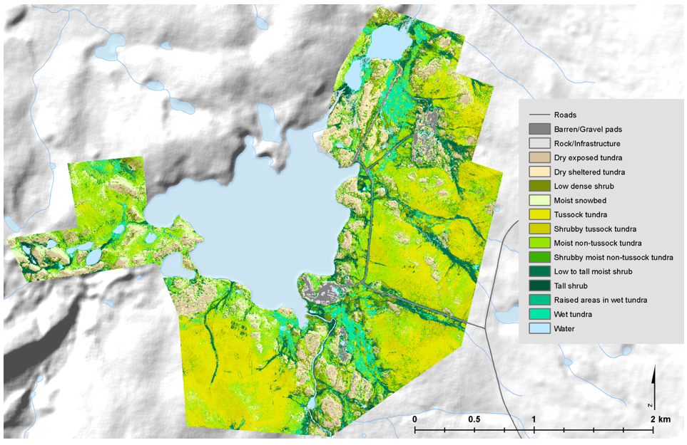
Federal
High-Resolution Vegetation Community Maps, Toolik Lake Area, Alaska, 2013-2015
National Aeronautics and Space Administration —
This dataset contains vegetation community maps at 20 cm resolution for three landscapes near the Toolik Lake research area in the northern foothills of the Brooks...

Official websites use .gov
A
.gov website belongs to an official government
organization in the United States.
Secure .gov websites use HTTPS
A
lock (
) or https:// means you’ve safely connected to
the .gov website. Share sensitive information only on official,
secure websites.