
-
Federal
H05891: NOS Hydrographic Survey
National Oceanic and Atmospheric Administration, Department of Commerce —
The National Oceanic and Atmospheric Administration (NOAA) has the statutory mandate to collect hydrographic data in support of nautical chart compilation for safe... -
Federal
Environmental baselines in Long Island Sound, 1972 to 1975 : tables and figures : final report (NCEI Accession 8300070)
National Oceanic and Atmospheric Administration, Department of Commerce —
Benthic species, marine sediments, and temperature profile data were collected using bottle in the Long Island Sound from 01 January 1972 to 31 December 1975. Data... -
Federal
Coastwide Reference Monitoring System (CRMS) 2005, 2008, 2012, and 2015 Site 0549 Land-Water Matrix
Department of the Interior —
Wetland restoration efforts conducted by the Coastal Wetlands Planning, Protection, and Restoration Act (CWPPRA) in Louisiana rely on monitoring efforts to determine... -
City
Louisville Metro KY – Security Deposit and Rental Deposit
Louisville Metro Government —
The Security Deposit and Rental Assistance program provides financial assistance (security deposit and up to two month's rent) for tenants moving to a new unit.Data... -
Federal
Walton-Smith CTD, WS19322, WS19322_StnCAL8, 2019-11-23, 26.0622N 82.0447W
National Oceanic and Atmospheric Administration, Department of Commerce —
Walton-Smith Conductivity, Temperature, Depth (CTD) - WS19322 - WS19322_StnCAL8 - 2019-11-23 - 26.0622N 82.0447W. Hydrographic Measurements in the Gulf of Mexico.... -
Federal
EM122 Water Column Sonar Data Collected During AT38
National Oceanic and Atmospheric Administration, Department of Commerce —
Cruise AT38 on RV Atlantis (EM122) -
Federal
CURRENT - DIRECTION and Other Data from UNKNOWN from 1962-01-01 to 1962-12-01 (NCEI Accession 6900974)
National Oceanic and Atmospheric Administration, Department of Commerce —
-
Federal
TIGER/Line Shapefile, 2022, County, Forsyth County, NC, Address Range-Feature
U.S. Census Bureau, Department of Commerce —
The TIGER/Line shapefiles and related database files (.dbf) are an extract of selected geographic and cartographic information from the U.S. Census Bureau's Master... -
Federal
Walton-Smith CTD, WS18120, WS18120_WS18120STN57, 2018-05-02, 25.3512N 81.2648W
National Oceanic and Atmospheric Administration, Department of Commerce —
Walton-Smith Conductivity, Temperature, Depth (CTD) - WS18120 - WS18120_WS18120STN57 - 2018-05-02 - 25.3512N 81.2648W. Hydrographic Measurements in the Gulf of... -
Federal
TIGER/Line Shapefile, 2022, County, Pulaski County, AR, Linear Hydrography
U.S. Census Bureau, Department of Commerce —
The TIGER/Line shapefiles and related database files (.dbf) are an extract of selected geographic and cartographic information from the U.S. Census Bureau's Master... -
Federal
Discerning between infil-excess, saturation-excess runoff regimes
U.S. Environmental Protection Agency —
This dataset uses field data to better understand how urban soils may tend toward infiltration- or saturation-excess runoff regimes, what the runoff ratio might be... -
Federal
TIGER/Line Shapefile, Current, County, Johnson County, TN, Feature Names Relationship File
U.S. Census Bureau, Department of Commerce —
The TIGER/Line shapefiles and related database files (.dbf) are an extract of selected geographic and cartographic information from the U.S. Census Bureau's Master... -
Federal
TIGER/Line Shapefile, 2023, County, Jeff Davis County, GA, Address Ranges Relationship File
U.S. Census Bureau, Department of Commerce —
The TIGER/Line shapefiles and related database files (.dbf) are an extract of selected geographic and cartographic information from the U.S. Census Bureau's Master... -
Federal
SGS-LTER Earthwatch - In situ Nitrogen Mineralization on Native, Abandoned and Cultivated Fields in eastern Colorado, USA in 1991
Department of Agriculture —
This data package was produced by researchers working on the Shortgrass Steppe Long Term Ecological Research (SGS-LTER) Project, administered at Colorado State... -
Federal
Coastwide Reference Monitoring System (CRMS) 2016 Site 0258 land-water classification data
Department of the Interior —
Wetland restoration efforts conducted by the Coastal Wetlands Planning, Protection and Restoration Act (CWPPRA) in Louisiana rely on monitoring efforts to determine... -
Federal
Delayed union of femoral fractures in older rats:decreased gene expression
U.S. Department of Health & Human Services —
Background Fracture healing slows with age. While 6-week-old rats regain normal bone biomechanics at 4 weeks after fracture, one-year-old rats require more than 26... -
Federal
TIGER/Line Shapefile, Current, County, Paulding County, GA, Address Range-Feature Name Relationship File
U.S. Census Bureau, Department of Commerce —
The TIGER/Line shapefiles and related database files (.dbf) are an extract of selected geographic and cartographic information from the U.S. Census Bureau's Master... -
Federal
Substance 865897: MLS000042493
U.S. Department of Health & Human Services —
Chemical substance data from PubChem database. This dataset contains comprehensive chemical information including structural data, physical properties, and biological... -
City
Synthetic Turf Fields
City of New York —
Synthetic turf systems located on NYC Parks properties. Explore the Data Dictionary -
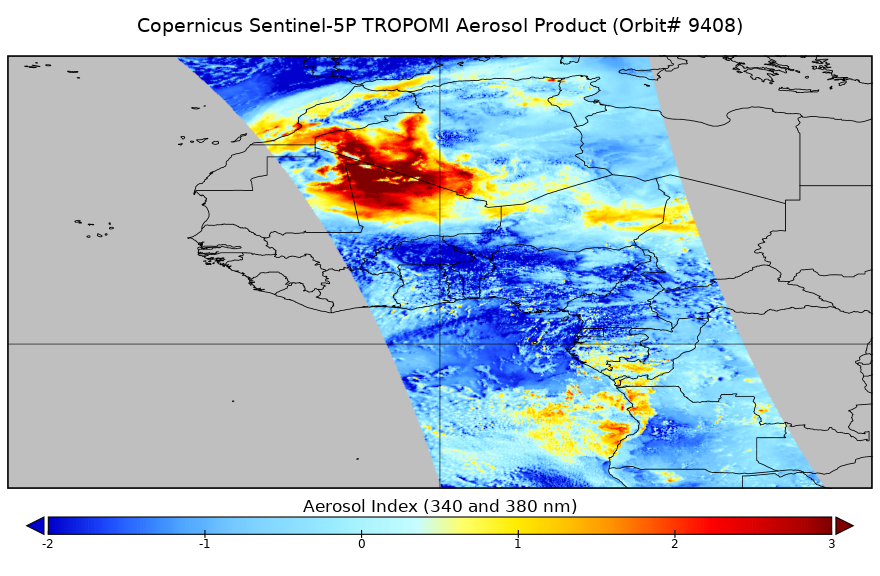
Federal
Sentinel-5P TROPOMI Near-Real-Time (NRT) Aerosol Index 1-Orbit L2 5.5km x 3.5km V2 (S5P_L2__AER_AI_HiR_NRT) at GES DISC
National Aeronautics and Space Administration —
The Sentinel-5P TROPOMI Near Real Time (NRT) Aerosol Index 1-Orbit L2 5.5km x 3.5km V2 (S5P_L2__AER_AI_HiR_NRT) at GES DISC is the near real time version of the...

Official websites use .gov
A
.gov website belongs to an official government
organization in the United States.
Secure .gov websites use HTTPS
A
lock (
) or https:// means you’ve safely connected to
the .gov website. Share sensitive information only on official,
secure websites.