
-
Federal
NOAA/WDS Paleoclimatology - Chernykh - Tsypinsky Pogost Church of Elijah the Prophet - PISP - ITRDB RUSS285
National Oceanic and Atmospheric Administration, Department of Commerce —
This archived Paleoclimatology Study is available from the NOAA National Centers for Environmental Information (NCEI), under the World Data Service (WDS) for... -
Federal
"NEGOM CTD - n4l04s01.nc - 30.22N, 87.35W - 1998-11-22"
National Oceanic and Atmospheric Administration, Department of Commerce —
The Northeastern Gulf of Mexico Physical Oceanography Program (NEGOM) is supported by the Minerals Management Service (MMS) of the U.S. Department of the Interior.... -
Federal
TIGER/Line Shapefile, 2023, County, Vega Baja Municipio, PR, Address Range-Feature
U.S. Census Bureau, Department of Commerce —
The TIGER/Line shapefiles and related database files (.dbf) are an extract of selected geographic and cartographic information from the U.S. Census Bureau's Master... -
Federal
TIGER/Line Shapefile, 2022, County, Ketchikan Gateway Borough, AK, Area Hydrography
U.S. Census Bureau, Department of Commerce —
The TIGER/Line shapefiles and related database files (.dbf) are an extract of selected geographic and cartographic information from the U.S. Census Bureau's Master... -
Federal
TIGER/Line Shapefile, Current, County, Barbour County, AL, Feature Names Relationship File
U.S. Census Bureau, Department of Commerce —
The TIGER/Line shapefiles and related database files (.dbf) are an extract of selected geographic and cartographic information from the U.S. Census Bureau's Master... -
Federal
TIGER/Line Shapefile, 2023, County, Washakie County, WY, Address Ranges Relationship File
U.S. Census Bureau, Department of Commerce —
The TIGER/Line shapefiles and related database files (.dbf) are an extract of selected geographic and cartographic information from the U.S. Census Bureau's Master... -
Federal
2024 Cartographic Boundary File (SHP), Unified School District for United States, 1:500,000
U.S. Census Bureau, Department of Commerce —
The 2024 cartographic boundary shapefiles are simplified representations of selected geographic areas from the U.S. Census Bureau's Master Address File /... -
Federal
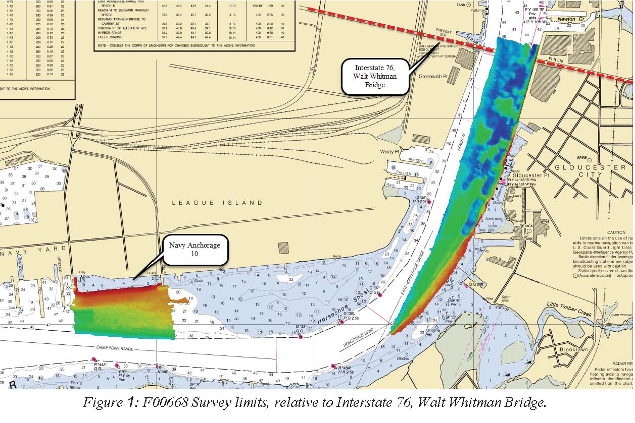
F00668: NOS Hydrographic Survey , 2015-10-22
National Oceanic and Atmospheric Administration, Department of Commerce —
The National Oceanic and Atmospheric Administration (NOAA) has the statutory mandate to collect hydrographic data in support of nautical chart compilation for safe... -
Federal
TIGER/Line Shapefile, 2024, County, Carroll County, NH, All Lines
U.S. Census Bureau, Department of Commerce —
The TIGER/Line shapefiles and related database files (.dbf) are an extract of selected geographic and cartographic information from the U.S. Census Bureau's Master... -
Federal
TIGER/Line Shapefile, Current, County, Johnson County, IL, Topological Faces-Area Hydrography Relationship File
U.S. Census Bureau, Department of Commerce —
The TIGER/Line shapefiles and related database files (.dbf) are an extract of selected geographic and cartographic information from the U.S. Census Bureau's Master... -
Federal
HTAP_v2.2: a mosaic of regional and global emission gridmaps for 2008 and 2010 to study hemispheric transport of air pollution.
U.S. Environmental Protection Agency —
This dataset provides the EPA portion of a compilation of different regional gridded inventories, including data from Environment Canada for Canada, the European... -
Federal
TIGER/Line Shapefile, 2020, County, Somervell County, TX, Topological Faces (Polygons With All Geocodes)
U.S. Census Bureau, Department of Commerce —
The TIGER/Line shapefiles and related database files (.dbf) are an extract of selected geographic and cartographic information from the U.S. Census Bureau's Master... -
Federal
Lake Hermitage Marsh Creation– NRDA Early Restoration Project: 2018 land-water classification
Department of the Interior —
The Louisiana Coastal Protection and Restoration Authority and the Natural Resource Damage Assessment (NRDA) develop restoration plans in order to conserve, restore,... -
Federal
Feb 1997 Current Population Survey: Basic Monthly
Department of Commerce —
To provide estimates of employment, unemployment, and other characteristics of the general labor force, of the population as a whole, and of various subgroups of the... -
Federal
TIGER/Line Shapefile, 2023, State, Connecticut, Point Landmark
U.S. Census Bureau, Department of Commerce —
The TIGER/Line shapefiles and related database files (.dbf) are an extract of selected geographic and cartographic information from the U.S. Census Bureau's Master... -
Federal
ASTEROID TAXONOMY V6.0
National Aeronautics and Space Administration —
This data set is a collection of asteroid taxonomic classifications from various classification methods, collected from the literature. -
Federal
TIGER/Line Shapefile, 2023, County, Randolph County, IN, All Roads
U.S. Census Bureau, Department of Commerce —
The TIGER/Line shapefiles and related database files (.dbf) are an extract of selected geographic and cartographic information from the U.S. Census Bureau's Master... -
Federal
TIGER/Line Shapefile, 2024, County, Pontotoc County, MS, Topological Faces-Area Hydrography Relationship File
U.S. Census Bureau, Department of Commerce —
The TIGER/Line shapefiles and related database files (.dbf) are an extract of selected geographic and cartographic information from the U.S. Census Bureau's Master... -
Federal
TIGER/Line Shapefile, 2024, County, Cowley County, KS, Area Hydrography
U.S. Census Bureau, Department of Commerce —
The TIGER/Line shapefiles and related database files (.dbf) are an extract of selected geographic and cartographic information from the U.S. Census Bureau's Master... -
Federal
Vector reports between salt marsh elevation observation points and the base station used for Assateague Island National Seashore, Fire Island National Seashore, and Gateway National Recreation Area-Sandy Hook Unit
Department of the Interior —
The data set includes vector reports of kinematic observations between the base station used for each survey and the rover points.

Official websites use .gov
A
.gov website belongs to an official government
organization in the United States.
Secure .gov websites use HTTPS
A
lock (
) or https:// means you’ve safely connected to
the .gov website. Share sensitive information only on official,
secure websites.