

3,071 datasets found for "麻将胡了试玩✅澳门葡京赌场官方网站-网址【079.one】㊙️最火爆PG电子超高爆奖率,注册即送38元.rwnnxvUlPNjprZ"
-
State
Water Rights Demand Analysis Methodology Datasets
State of California —
The following datasets are used for the Water Rights Demand Analysis project and are formatted to be used in the calculations. The State Water Resources Control Board... -
Federal
Palo Alto Battlefield National Historical Park Winter Bird Monitoirng Data FY 2012
Department of the Interior —
Data are part of the GULN Inventory and Monitoring Program Landbird monitoring project for PAAL. Data were collected by Eric Linder through a cooperative agreement... -
Federal
LRIR/Nimbus-6 Level 2 Inverted Profiles of Temperature and Ozone V001 (LRIRN6L2IPAT) at GES DISC
National Aeronautics and Space Administration —
LRIRN6L2IPAT is the Nimbus-6 Limb Radiance Inversion Radiometer (LRIR) Level 2 Inverted Profiles of Temperature and Ozone data product. The product contains daily... -
Federal
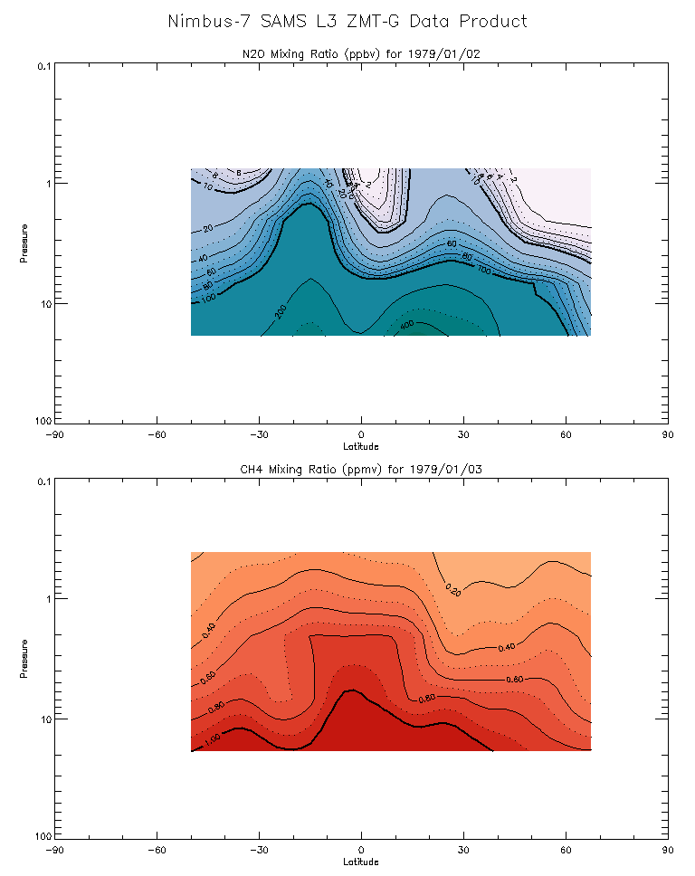
SAMS/Nimbus-7 Level 3 Zonal Means Composition Data V001 (SAMSN7L3ZMTG) at GES DISC
National Aeronautics and Space Administration —
SAMSN7L3ZMTG is the Nimbus-7 Stratospheric and Mesospheric Sounder (SAMS) Level 3 Zonal Means Composition Data Product. The Earth's surface is divided into 2.5-deg... -
Federal
TIROS-4 Medium-Resolution Scanning Radiometer Level 1 Final Meteorological Radiation Data V001 (TIROS4L1FMRT) at GES DISC
National Aeronautics and Space Administration —
TIROS-4 Medium-Resolution Scanning Radiometer Level 1 Final Meteorological Radiation Data (FMRT) product contains radiances expressed in five infrared/visible... -
Federal
TIROS-3 Medium-Resolution Scanning Radiometer Level 1 Final Meteorological Radiation Data V001 (TIROS3L1FMRT) at GES DISC
National Aeronautics and Space Administration —
TIROS-3 Medium-Resolution Scanning Radiometer Level 1 Final Meteorological Radiation Data (FMRT) product contains radiances expressed in five infrared/visible... -
Federal
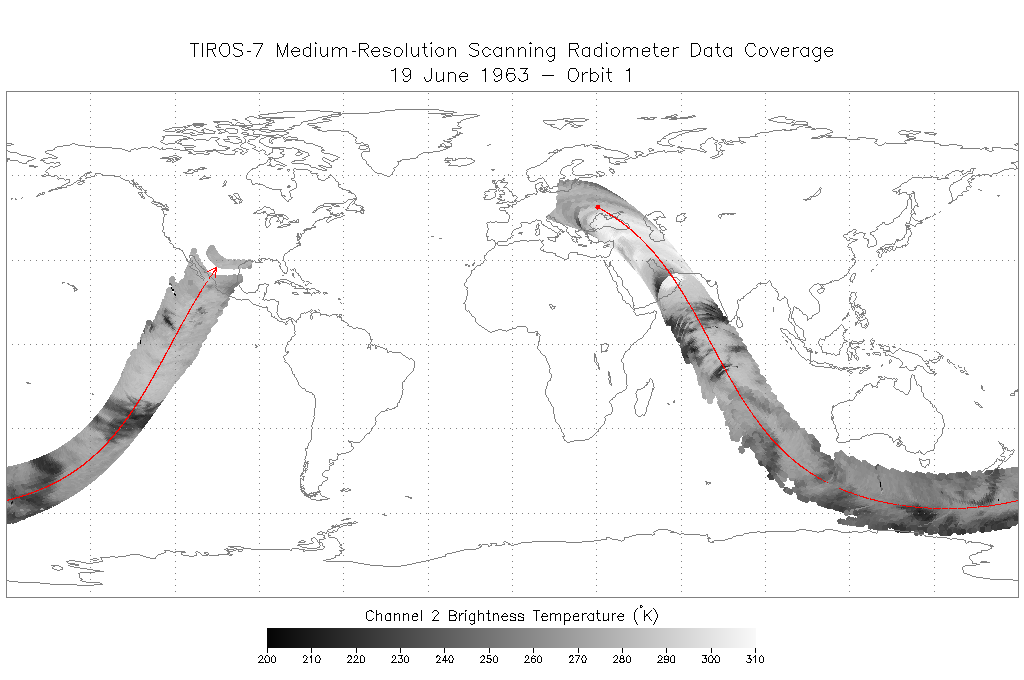
TIROS-7 Medium-Resolution Scanning Radiometer Level 1 Final Meteorological Radiation Data V001 (TIROS7L1FMRT) at GES DISC
National Aeronautics and Space Administration —
TIROS-7 Medium-Resolution Scanning Radiometer Level 1 Final Meteorological Radiation Data (FMRT) product contains radiances expressed in five infrared/visible... -
Federal
Extraction Lookup Table - Supplemental Materials to Modelling Effects of Flow Withdrawal Scenarios on Riverine and Riparian Features of the Yampa River in Dinosaur National Monument
Department of the Interior —
The Extraction Lookup Tables in this supplemental file reflect the results of the analyses of historical and alternative hydrographs, reflecting potential water... -
Federal
Dataset: Habitat Condition and Diet of the Chisana caribou herd, Wrangell-St. Elias National Park and Preserve, Alaska
Department of the Interior —
Dataset for the Habitat Condition and Diet of the Chisana caribou herd, Wrangell-St. Elias National Park and Preserve, Alaska Project (IRMA Data Store: 2306144). This... -
State
Los Angeles River Restoration and Access (LLARRA) Water Quality Analysis - Lower Los Angeles River - 2024-2025
State of California —
WCB Grant 2023114: Lower Los Angeles River Restoration and Access: Data includes one (1) year of water quality analysis to inform the design and serve as a baseline... -
Federal
BLM Natl WesternUS FIAT Project Planning Areas 2015 Polygon
Department of the Interior —
This data represents a management strategy of the Fire and Invasives Assessment Tool (FIAT). Project Planning Area (PPA) polygons are part of the FIAT Step 2 process.... -
Federal
DWH NRDA Low Level Aerial Surveys
Department of the Interior —
Aerial surveys associated with Deepwater Horizon Bird Study #2 occurred during the summer of 2010 and the winter of 2011. Data collection efforts were led by R.G.... -
Federal
Priority Resources of Concern for Stillwater National Wildlife Refuge Complex - Data Documentation
Department of the Interior —
A collection of data serving as documentation of Stillwater National Wildlife Refuge Complex priority resources of concern. -
Federal
Knapweed Monitor [Ouray National Wildlife Refuge : 2017]
Department of the Interior —
This spreadsheet details the monitoring of Russian knapweed, among other species, on the Ouray National Wildlife Refuge between the years 2003 and 2017. Data is... -
Federal
Little Pend Oreille NWR: 2015-2017 - Continuous Air and Stream Temperature Data at Little Pend Oreille River (Aquatic Health and Climate Change) - Raw and Processed Data
Department of the Interior —
Continuous Temperature Data. Raw Hobo data files collected at Little Pend Oreille NWR (Little Pend Oreille River) and compiled at a regular frequency into a annual... -
Federal
Priority Resources of Concern for San Luis National Wildlife Refuge Complex - Data Documentation
Department of the Interior —
A collection of data serving as documentation of San Luis National Wildlife Refuge Complex priority resources of concern. -
Federal
Wapato Lake NWR: Bathymetric & Inundation Modeling: Modeled Water Depth, Raster Model Outputs
Department of the Interior —
The USGS Shoreline Management Tool (SMT), An ArcMap Tool for Analyzing Water Depth, Inundated Area, Volume, and Selected Habitats was used to determine the spatial... -
Federal
Malheur NWR: Continuous Air and Stream Temperature Data at Bridge Creek (Aquatic Health and Climate Change) - Raw and Processed Data
Department of the Interior —
Continuous Temperature Data. Raw Hobo data files collected at Malheur NWR (Bridge Creek) and compiled at a regular frequency into a annual (cleaned) dataset (Excel).... -
Federal
VMS Midwater Trawl 2010-2017 (BOEM)
Department of the Interior —
2010-2017 Vessel Monitoring System (VMS) data were used from the NOAA Office of Law Enforcement to create this fishing effort dataset for the U.S. West Coast. The... -
Federal
seep anomaly confirmed hydrate NGDA
Department of the Interior —
Since 1998, geoscientists at the Bureau of Ocean Energy Management (BOEM) have identified and mapped over 31,000 water bottom (seafloor) acoustic amplitude anomalies...
3,071 datasets found for "麻将胡了试玩✅澳门葡京赌场官方网站-网址【079.one】㊙️最火爆PG电子超高爆奖率,注册即送38元.rwnnxvUlPNjprZ"