
-
Federal
Central American Vegetation/Land Cover Classification and Conservation Status
National Aeronautics and Space Administration —
The Central American Vegetation/Land Cover Classification and Conservation Status consists of GIS coverages of vegetation classes (forests, woodlands, savannas,... -
Federal
Gridded Population of the World, Version 3 (GPWv3): National Administrative Boundaries
National Aeronautics and Space Administration —
The Gridded Population of the World, Version 3 (GPWv3): National Administrative Boundaries are derived from the land area grid to show the outlines of pixels (cells)... -
Federal
Global Reservoir and Dam Database, Version 1 (GRanDv1): Reservoirs, Revision 01
National Aeronautics and Space Administration —
Global Reservoir and Dam Database, Version 1, Revision 01 (v1.01) contains 6,862 records of reservoirs and their associated dams with a cumulative storage capacity of... -
Federal
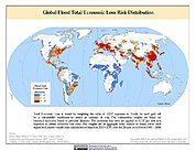
Global Flood Total Economic Loss Risk Deciles
National Aeronautics and Space Administration —
The Global Flood Total Economic Loss Risk Deciles is a 2.5 minute grid of global flood total economic loss risks. A process of spatially allocating Gross Domestic... -
Federal
West Africa Coastal Vulnerability Mapping: GPW Version 4 Population Density, Preliminary Release 1, 2010
National Aeronautics and Space Administration —
The West Africa Coastal Vulnerability Mapping: GPW Version 4 Population Density, Preliminary Release 1, 2010, represents the number of persons per square kilometer,... -
Federal
Millennium Ecosystem Assessment: MA Ecosystems
National Aeronautics and Space Administration —
The Millennium Ecosystem Assessment: MA Ecosystems provides data and information on the extent and classification of ecosystems circa 2000, including coastal,... -
Federal
Gridded Population of the World, Version 3 (GPWv3): Population Density Grid, Future Estimates
National Aeronautics and Space Administration —
The Gridded Population of the World, Version 3 (GPWv3): Population Density Grid, Future EstimatesFuture Estimates consists of estimates of human population for the... -
Federal
Last of the Wild Project, Version 1, 2002 (LWP-1): Global Human Footprint Dataset (Geographic)
National Aeronautics and Space Administration —
The Global Human Footprint Dataset of the Last of the Wild Project, Version 1, 2002 (LWP-1) is the Human Influence Index (HII) normalized by biome and realm. The HII... -
Federal
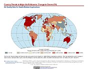
Country Trends in Major Air Pollutants
National Aeronautics and Space Administration —
The Country Trends in Major Air Pollutants data set is a framework of public-health-focused air quality indicators that quantifies over 200 countries' trends in... -
Federal
U.S. Census Grids (Summary File 3), 2000
National Aeronautics and Space Administration —
The U.S. Census Grids (Summary File 3), 2000 data set contains grids of demographic and socioeconomic data from the year 2000 U.S. census in ASCII and GeoTIFF... -
Federal
Millennium Ecosystem Assessment: MA Scenarios
National Aeronautics and Space Administration —
The Millennium Ecosystem Assessment: MA Scenarios provides data and information on population, income, cereal production and consumption, meat production and... -
Federal
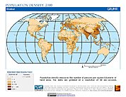
Global Rural-Urban Mapping Project, Version 1 (GRUMPv1): Population Density Grid
National Aeronautics and Space Administration —
The Global Rural-Urban Mapping Project, Version 1 (GRUMPv1): Population Density Grid estimates population per square km for the years 1990, 1995, and 2000 by 30 arc-... -
Federal
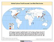
Global Cyclone Total Economic Loss Risk Deciles
National Aeronautics and Space Administration —
The Global Cyclone Total Economic Loss Risk Deciles is a 2.5 minute grid of global cyclone total economic loss risks. A process of spatially allocating Gross Domestic... -
Federal
Global Multihazard Mortality Risks and Distribution
National Aeronautics and Space Administration —
The Global Multihazard Mortality Risks and Distribution is a 2.5 minute grid identifying and characterizing the nature of multihazard risk at the global scale. For... -
Federal
Global 15 x 15 Minute Grids of the Downscaled Population Based on the SRES B2 Scenario, 1990 and 2025
National Aeronautics and Space Administration —
The Global 15x15 Minute Grids of the Downscaled Population Based on the Special Report on Emissions Scenarios (SRES) B2 Scenario, 1990 and 2025, are geospatial... -
Federal
Natural Resource Protection and Child Health Indicators, 2023 Release
National Aeronautics and Space Administration —
The Natural Resource Protection and Child Health Indicators, 2023 Release, is produced in support of the U.S. Millennium Challenge Corporation as selection criteria... -
Federal
CODATA Catalog of Roads Data Sets, Version 1
National Aeronautics and Space Administration —
The CODATA Catalog of Roads Data Sets, Version 1 contains 367 entries describing national-level road network data sets for 147 countries and four entries describing... -
Federal
China Dimensions Data Collection: China Maps Bibliographic Database
National Aeronautics and Space Administration —
The China Maps Bibliographic Database is an historical collection of bibliographic information for more than 400 maps of China. The information resides in a... -
Federal
Gridded Population of the World, Version 4 (GPWv4): Land and Water Area, Revision 11
National Aeronautics and Space Administration —
The Gridded Population of the World, Version 4 (GPWv4): Land and Water Area, Revision 11 consists of two rasters that measure surface areas of land and water in... -
Federal
Pilot 2006 Environmental Performance Index (EPI)
National Aeronautics and Space Administration —
The Pilot 2006 Environmental Performance Index (EPI) centers on two broad environmental protection objectives: (1) reducing environmental stresses on human health,...

Official websites use .gov
A
.gov website belongs to an official government
organization in the United States.
Secure .gov websites use HTTPS
A
lock (
) or https:// means you’ve safely connected to
the .gov website. Share sensitive information only on official,
secure websites.